Places
26 places found.
Those places high-lighted have photos. All locations may have maps, books and memories.
- Cemmaes Road, Powys
- Six Road Ends, County Down
- Road Weedon, Northamptonshire
- Severn Road Bridge, Gloucestershire
- Roade, Northamptonshire
- Berkeley Road, Gloucestershire
- Harling Road, Norfolk
- Road Green, Devon
- Builth Road, Powys
- Cross Roads, Yorkshire
- Steele Road, Borders
- Cross Roads, Devon
- Four Roads, Dyfed
- Road Green, Norfolk
- Biggar Road, Strathclyde
- Clarbeston Road, Dyfed
- Five Roads, Dyfed
- Eccles Road, Norfolk
- Grampound Road, Cornwall
- Morchard Road, Devon
- Wood Road, Greater Manchester
- Four Roads, Isle of Man
- St Columb Road, Cornwall
- Clipiau, Gwynedd (near Cemmaes Road)
- New Road Side, Yorkshire (near Silsden)
- New Road Side, Yorkshire (near Cleckheaton)
Photos
14,329 photos found. Showing results 921 to 940.


Maps
476 maps found.
Books
5 books found. Showing results 1,105 to 5.
Memories
11,058 memories found. Showing results 461 to 470.
Scarning School
At the age of 5yrs I started my education at Scarning School, I lived at Woodhill [see memory of Dereham] which meant about a 2 mile walk to school with my 10 yr old sister usually stopping to play in the stream at Podmore on the ...Read more
A memory of Scarning in 1920 by
When I Was A Child
I can clearly remember pushing my doll's pram up to the shops with my mother from our home in South Mossley, Hill Road. I was always fascinated by the overhead cash delivery system in the Co-op shops. The very end shop was the ...Read more
A memory of Liverpool in 1955 by
My First Home
This is a photograph of the house where I was born. My parents bought the house in Long Street, Tetbury when they got married in 1937, I was born in 1939 and my brother followed five years later. This house is very old and very ...Read more
A memory of Tetbury in 1953 by
The Long Hole
As in the title this mooring place beside Seacliff Road is known as the Long Hole, two separate words. Many thanks for this correction - the archive has been updated, Regards, Editor.
A memory of Bangor by
Great Memories
I lived with my family in Windsor Avenue after 2WW. Oak Farm Primary was the school I went to which was just down the road. In 1951/52 the school had a choir, Mr. Roberts was the Head Master. I was in this choir. There was a record ...Read more
A memory of Hillingdon by
Famous Arch
As a child, during school holidays I would stay with my Grand-parents in Newton Abbot and often travel to Torquay on the smart dark red number 12 Devon General bus. On the journey I would look out for the tunnel at Kingskerswell near ...Read more
A memory of Kingskerswell by
Along The Barking Road
I was born at 37 Alexandra Street. At the corner where our street met the Barking Road, opposite Star Lane and Mulcasters seed shop, was the bombed Odeon where we would play as children. I recall a pea souper fog in the late ...Read more
A memory of Canning Town by
Happy Days In Coulsdon, 1947 To 1955
Born in Purley Hospital in 1947, we lived in Bramley Avenue for the first 2 years of my life, but of course I have no memories of that. We then moved to 30 Grove Wood Hill, which is off Woodcote Grove Road. I had ...Read more
A memory of Coulsdon by
Many Memories
I went to the school here. Mrs Foster was my Teacher and Mr Pritchard was the Head Master. We would cross the road to the village hall for Dinner. I vaguely remember having music lessons in the hall too (We all had recorder ...Read more
A memory of Standon by
Growing Up In Cold Ash
I spent the early years of my life in Cold Ash and Thatcham. We lived in a detached house on Cold Ash Hill called Midway. I believe it has since been renamed. The house was built by my grand father Alfred Gadd, the carpenter, ...Read more
A memory of Cold Ash by
Your search returned a large number of results. Please try to refine your search further.
Captions
5,036 captions found. Showing results 1,105 to 1,128.

The post office and shop are at the junction with the Haverhill Road and the village green. In the distance is a very fine 17th-century farmhouse with a jettied cross-wing.

We are looking from just inside Birmingham Road up Castle Hill, with Tipton Road off to the right. On the extreme left is the Station Garage, then an Austin dealership.

In these days this was a country lane joining Trapp's Lane and the London Road.

As every school child knows, the Romans built long straight roads; Redbourn High Street is no exception, for it forms part of the Roman Watling Street.

The turnpike road through Charmouth was run by the Bridport District Trust from 1764 to 1877. For several decades in the next century it carried the A35 Folkestone to Honiton trunk road.

As the town became more industrialised, the old Dispensary (in College Street since 1828) was replaced by this fine hospital in 1872, built in Babb's Croft along the Doncaster Road.

Looking east along the road, the view encompasses the ruined church and the little tower on the small promontory above the harbour. The only traffic is a small pony and trap.

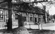
The road outside this attractive timber-framed and weatherboarded house has changed little over the years. Note the impressive chimneys, both on the side and in the centre of the building.

Pednolver Walk, or 'Lambeth Walk', leading from Westcott's Quay to Wharf Road. This view shows the narrow promenade without its railings, which were added in a later more safety-conscious age.

In Roman times a road ran west from here across the present ground of the New Forest to Ringwood.

Despite increases in population and the subsequent rise in road traffic, Herefordshire still manages to retain an aura of peacefulness and serenity, exemplified in this photograph.

Despite increases in population and the subsequent rise in road traffic, Herefordshire still manages to retain an aura of peacefulness and serenity, exemplified in this photograph.

Prince of Wales Road was cut through the town in 1862 to provide a fittingly grand route from Thorpe Station. On the right, the old Crown Bank of 1866 became the post office.

Sixty years on, Beccles has declined as a port, with goods being carried more by road. The church is unusual in that the 92 feet high tower is actually separate from the nave.
Despite increases in population and the subsequent rise in road traffic, Herefordshire still manages to retain an aura of peacefulness and serenity, exemplified in this photograph.

The road leads down to the River Ouse and Buckden Mills.

This is Kingsbury Square, with St Edith's church on the left.The road across the square is the A30.

The outbuilding on the right is now The Cat's Whiskers, a hairdresser's whose name wittily puns on the road name.

The coach road leaves the town centre over the River Welland, from where this view was taken. Many Georgian houses throughout the town remain, and its buildings are always worth a second look.

For a while the Bewleys' only local rival had been the London Road Ironworks, which was opposite a house called The Cloisters.

A view showing, on the right, the approach road into Staithes, again illustrating the picturesque nature of the buildings.

The view shows Digby Road and the Digby Hotel. This hotel was built by George Digby Wingfield Digby and it opened on Pack Monday, 11 October 1869. An Assembly Room was added in 1878.

The A6 road runs across the Common at Harpenden, under the 'Baa Lamb' trees and into the High Street.

Sited on the Haywards Road junction, the white building on the extreme right is Lloyds Bank; this building was later demolished, but Lloyds are still on the same site.
Places (26)
Photos (14329)
Memories (11058)
Books (5)
Maps (476)

