Merry Christmas & Happy New Year!
Christmas Deliveries: If you placed an order on or before midday on Friday 19th December for Christmas delivery it was despatched before the Royal Mail or Parcel Force deadline and therefore should be received in time for Christmas. Orders placed after midday on Friday 19th December will be delivered in the New Year.
Please Note: Our offices and factory are now closed until Monday 5th January when we will be pleased to deal with any queries that have arisen during the holiday period.
During the holiday our Gift Cards may still be ordered for any last minute orders and will be sent automatically by email direct to your recipient - see here: Gift Cards
Places
36 places found.
Those places high-lighted have photos. All locations may have maps, books and memories.
- Shanklin, Isle of Wight
- Ventnor, Isle of Wight
- Ryde, Isle of Wight
- Cowes, Isle of Wight
- Sandown, Isle of Wight
- Port of Ness, Western Isles
- London, Greater London
- Cambridge, Cambridgeshire
- Dublin, Republic of Ireland
- Killarney, Republic of Ireland
- Douglas, Isle of Man
- Plymouth, Devon
- Newport, Isle of Wight
- Southwold, Suffolk
- Bristol, Avon
- Lowestoft, Suffolk
- Cromer, Norfolk
- Edinburgh, Lothian
- Maldon, Essex
- Clacton-On-Sea, Essex
- Felixstowe, Suffolk
- Norwich, Norfolk
- Hitchin, Hertfordshire
- Stevenage, Hertfordshire
- Colchester, Essex
- Nottingham, Nottinghamshire
- Bedford, Bedfordshire
- Bury St Edmunds, Suffolk
- Aldeburgh, Suffolk
- St Albans, Hertfordshire
- Hunstanton, Norfolk
- Chelmsford, Essex
- Bishop's Stortford, Hertfordshire
- Peterborough, Cambridgeshire
- Brentwood, Essex
- Glengarriff, Republic of Ireland
Photos
9,107 photos found. Showing results 421 to 440.


Maps
181,006 maps found.


Books
11 books found. Showing results 505 to 11.
Memories
29,071 memories found. Showing results 211 to 220.
Hobbs Farm
Our family moved from Bognor to Yapton in 1951 just before my 10th birthday. I was only 13 and attending Chichester High School for Girls when I started working weekends at Hobbs Farm, Bilsham Corner. It was a pedigree Jersey dairy farm ...Read more
A memory of Yapton in 1954 by
Family Tree
Since my parents died within a few weeks of each other a few years ago I have been looking into my father's family tree, and it seems all his relatives came from Mark in Somerset so I hope to visit there soon to trace my family tree ...Read more
A memory of Mark by
When It Was An Aerodrome !
Ok, so it may have been a little later than 1955, but we used to live in Southbourne Grove, and used to thrash our bicycles across the fields (over the arterial road) and make our way to the back of the airport ...Read more
A memory of Southend Airport in 1955 by
Chudleigh Knighton Cider Memories
I lived in Chudleigh Knighton when I was 11 years old until I was 15. That was 1932 till 1936. I was taught at the lovely school there. The head mistress was Miss Gill and her assistants Miss Bray and ...Read more
A memory of Chudleigh Knighton in 1930 by
Zeals House
I was evacuated to Zeals during the war from London, to I think, Zeals House. I recall the airfield, and I remember a local pub, which I think had a yew tree outside. My folks and military members would drink and dance outside under the ...Read more
A memory of Zeals in 1940 by
Schools
I was five and walked down this road to the infants school on the left (you can just see the school railings). My future primary school (St Johns) is in the old building to the right. There was a little sweet shop on the left (out of shot ...Read more
A memory of Essington in 1965 by
Hells Angels In The Box
I'm not sure if the box was still in use in 1965. I remember it better about five years later when Hells Angels used it as a type of den. We (a few mates and I) used to walk the railway line from the pithead to Broad Lane ...Read more
A memory of Essington in 1965 by
Key Factory
The long low building to the rear of the picture I remember as the Key factory (Huffs), my mom worked there for some time and we would rush to meet her on payday to get our treat. It was one of the few places in Essington to employ ...Read more
A memory of Essington in 1965 by
My Apprentice Days With Northmet Electricity (Eeb)
I was born in Elmgrove Crescent Harrow in 1933 and lived in Pinner Road North Harrow, moving to Wealdstone in 1934. I started at Bridge Scool in 1938 and followed on to Belmont Sec. Modern School ...Read more
A memory of Kenton in 1948 by
Kennards
Kennards had the little zoo where a monkey in a tiny cage reached out and pulled my sister's hair. This was about the year of Queen Elizabeth's coronation. We went down to Woolworth’s and were given free Union Jack flags. Upstairs in ...Read more
A memory of Croydon by
Your search returned a large number of results. Please try to refine your search further.
Captions
29,158 captions found. Showing results 505 to 528.

The Royal Cumberland Cavern was one of several public show caves in Matlock Bath during the 1950s, and was well known for its formations of calcite and traces of the work of former lead miners.

This crossroads west of the village of Calver is known as Calver Sough - a sough (pronounced “suff”) being a drainage tunnel designed to take water out of lead mines.

As well as the Midland Bank on the left and the Windsor Arms on the right, this picture also features a branch of Thomas & Evans on the right-hand side of the picture.

This nine-storey block was a typical example of housing designed for single people. The first one was built on the corner of Mark Hall Moors in open parkland in the midst of seven magnificent oaks.

This jumble of stones, just to the north of St Thomas's Church, is all that remains of a priory so wealthy that it once lent money to the King.
This jumble of stones, just to the north of St Thomas's Church, is all that remains of a priory so wealthy that it once lent money to the King.

On the east side of the village, this is an undernourished Non- conformist chapel, in a sense a poor relation of the Methodist church in Castle Donington.

The Cotswolds reach their highest point at West Down, 1083 feet above sea level, above this parish of Cleeve Hill, east of Cheltenham.

The story is told (which may or may not be true) that in 1154 thousands of people lined the old bridge to herald the arrival of Archbishop William Fitzherbert, later to become St William of York.

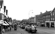
This very detailed photograph depicts one of Northampton's busiest streets.

Runswick Lane leads out of Hinderwell High Street to Runswick Bay, a local beauty spot much beloved by many Clevelanders.

As we move further eastwards, the vista concludes with this dramatic portrayal of Penarth Head and its cliffs.

Known today for its caravan parks and the long sandy beach of Black Rock sands, Morfa Bychan, just west of Porthmadog, was long celebrated for the story of Dafydd Garreg-Wen, the blind harpist, known for

Waddington is now noted more for its large Royal Air Force station to the east of the village, but it grew up on a diversion of Ermine Street to the western scarp of the limestone ridge.

During the summer of 1894, Oscar Wilde and his family occupied this house overlooking the sea at the eastern end of the extended Esplanade.
Visually unaltered, the memorial is still the focus of remembrance in the city.

The focal point of Forty Hill in the 16th century was the great house of Elsynge, which lay between the site of Forty Hall and the Turkey Brook.

This good view of the village pump captures some of the feel of the old village of Ickenham. The road has been widened substantially since this communal water supply was in regular use.

At the height of the coaching era, Maidenhead was littered with posting inns either side of the High Street. Some of these hotels continued to thrive during the age of the motor car.

Even before the arrival of the railway, Ware was home to a population of rising middle-class entrepreneurs who demanded the most modern housing.

Modern 1950s and 1960s houses of various different styles can be seen on the right of Great Houghton High Street in this photograph.

The Welds of Lulworth were one of the leading Roman Catholic families of England.

In 1965, the municipal borough of Twickenham was merged with those of Barnes and Richmond (against the wishes of many residents) to become the London Borough of Richmond-upon-Thames under the

The lines of parked vehicles on both sides of the road tend to detract from the architectural riches of the fine Tudor, Georgian and Victorian buildings that adorn this spacious street; they are evidence
Places (6814)
Photos (9107)
Memories (29071)
Books (11)
Maps (181006)

