Places
36 places found.
Those places high-lighted have photos. All locations may have maps, books and memories.
- Shanklin, Isle of Wight
- Ventnor, Isle of Wight
- Ryde, Isle of Wight
- Cowes, Isle of Wight
- Sandown, Isle of Wight
- Port of Ness, Western Isles
- London, Greater London
- Cambridge, Cambridgeshire
- Dublin, Republic of Ireland
- Killarney, Republic of Ireland
- Douglas, Isle of Man
- Plymouth, Devon
- Newport, Isle of Wight
- Southwold, Suffolk
- Bristol, Avon
- Lowestoft, Suffolk
- Cromer, Norfolk
- Edinburgh, Lothian
- Maldon, Essex
- Clacton-On-Sea, Essex
- Norwich, Norfolk
- Felixstowe, Suffolk
- Hitchin, Hertfordshire
- Stevenage, Hertfordshire
- Colchester, Essex
- Nottingham, Nottinghamshire
- Bedford, Bedfordshire
- Bury St Edmunds, Suffolk
- Aldeburgh, Suffolk
- St Albans, Hertfordshire
- Hunstanton, Norfolk
- Chelmsford, Essex
- Bishop's Stortford, Hertfordshire
- Peterborough, Cambridgeshire
- Brentwood, Essex
- Glengarriff, Republic of Ireland
Photos
9,106 photos found. Showing results 17,321 to 9,106.
Maps
181,006 maps found.


Books
11 books found. Showing results 20,785 to 11.
Memories
29,049 memories found. Showing results 8,661 to 8,670.
Hammonds Sauce Works Brass Band
For some reason my dad Ernest Carter around 1952/53 got all us Carter kids joined into the Hammond Sauce Works Brass band in SHIPLEY....DAD was a member of the BRADFORD City brass band. We'd go for practice Tuesday ...Read more
A memory of Shipley in 1951 by
My Ancestors Are Said To Have Originated From The Walls Of Thurland Castle.
Around 1706, my Ancestors are said to have originated from the walls of Thurland Castle. gillentineje@yahoo.com if you would like to contact me.
A memory of Thurland Castle by
Just A Kibbuth Lad
For those who have never been to our village called Kibworth, it is worth noting locals call it "Kibbuth". You live in either "Top Kibbuth"- Kibworth Harcourt or "Bottom Kibbuth"- Kibworth Beauchamp. I myself ...Read more
A memory of Kibworth Harcourt in 1973 by
Happy Days Of Youth
I lived at 10 Whitfield Road, Fulwood, and went to Birkdale Prep School. Used to spend hours playing around Forge Dam, and renting a rowboat if I got an allowance. When winter came we would toboggan down the hills in ...Read more
A memory of Fulwood in 1940 by
No 489 Squadron Flew From Raf Langham
A commemorative brass plaque in the church of St Andrew and St Mary, Langham was erected in memory of these men of 489 Torpedo Bomber Squadron RNZAF (and their comrades in other Coastal Command ...Read more
A memory of Langham in 1944 by
Seedhill Cottage
The house in the foreground is known as Seedhill Cottage. My family lived there from the mid sixties to late seventies. My father was the gamekeeper for the local shoot and water baliff for Whitewell area. My mother was the ...Read more
A memory of Whitewell in 1967 by
A Schoolboy In Petts Wood
My parents Arthur and Hilary Cork bought their house in Towncourt Crescent in 1927 from Mr Coleman for £1000. Twice a day I would walk to the station to go to school at St Dunstan's in Catford. In those days there was ...Read more
A memory of Petts Wood in 1930 by
Youth Club
Dear Paul, I feel I should know either you or your brother but don't. However, the Youth Club was originally Little Sutton library and prior to that the reading room. I remember going there to choose my books from a very young ...Read more
A memory of Little Sutton in 1965 by
Courtenay Park Salcombe
This view of Courtenay Park is quite poignant for me. It shows houses at the lower end of Devon Road and also the land on which Egremont Terrace was later built. My parents lived in no. 10 Egremont Terrace from the late ...Read more
A memory of Salcombe in 1950 by
Great Place Lost.
Grange Farm was the place to go for all teens. You could swim or just hang around with friends. To get there we walked across the fields and over the bridge across the Roding. Now of course this place is no more. A great loss.
A memory of Chigwell in 1957 by
Your search returned a large number of results. Please try to refine your search further.
Captions
29,158 captions found. Showing results 20,785 to 20,808.

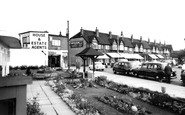
Well tended chalet gardens invite their occupants to sit outside and take in the sea air, obviously unpolluted by the fumes of heavy traffic.

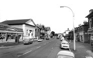
Here is a foretaste of the traffic problems that were to come.

Another picture of St Faith's Church, taken six years after the previous photograph. The trees have grown and the whole scene looks more rural.

The Forest of Dean was an extensive royal hunting ground between the Wye and the Severn, extending as far north as Ross and Gloucester.

The man with the horse and cart on the left is at the village pump, which is situated in front of the Methodist Chapel.

Maintaining safe navigation along the River Great Ouse is an ongoing task, which means dredging to ensure there is no build-up of silt.

A view from the Belmont Road area, revealing in more detail the sheer magnificence of the Grand Hotel. The four cupolas are clearly visible.

Apart from the fashions of the day, this view remains virtually the same today.
In 1111967 Accrington Corporation took over the maintenance of the graveyard at St James' Chruch. Several tombstones were removed, and the graveyard was tidied.

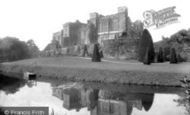
The Castle gateway is out of shot on the left.
Here is a foretaste of the traffic problems that were to come.

Here we see another corner of the King's bedroom. Both the bed canopy and the chair look somewhat tired, and are almost certainly dust-laden. Both have seen happier days.

The King's Arms is situated at the heart of this peaceful community.

Judging from the many children around the coach in the background, there appears to be a school outing going on. Ampleforth lies on the southern edge of the Hambledon Hills.

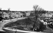
This large village with houses showing mixed building styles centres on the crossroads near St James's Church. Note the air raid siren above the door of the Old Black Swan.

The Cow Tower, with barges moored nearby, looks out from the edge of Cowholme, now in the riverside walk park, to the late 19th-century city expansion beyond the Wensum.

When Abbot Anselm laid out his grid pattern for the streets of Bury St Edmunds, Churchgate Street was planned as the main thoroughfare, a ceremonial route to St Edmund's shrine.

This is how the Feathers often looks today – festooned with summer hanging baskets full of flowers. Notice also the sign saying 'Machine Bakery' on the baker's shop to the right.

Before it was developed with grand apartments and hotels, gentlefolk, and even ladies on their own, as here, were able to stroll peaceably along this quiet stretch of West Cliff.

In a prominent position overlooking the town, the Castle was founded c1200 by William Fitz Martin, after he was ejected by the Welsh from his original stronghold of Nevern Castle.

This marvellous house has survived almost unchanged into our new century, and is one of Beer's oldest buildings.

It is on the site of the southern gateway of the Roman colonia. This area is now pedestrianised, and has greatly changed.
It is on the site of the southern gateway of the Roman colonia. This area is now pedestrianised, and has greatly changed.

The early 16th-century Queen's Armes is described by the Royal Commission on Historical Monuments as 'an unusually complete example of a small late medieval house'.
Places (6814)
Photos (9106)
Memories (29049)
Books (11)
Maps (181006)

