Places
Sorry, no places were found that related to your search.
Photos
Sorry, no photos were found that related to your search.
Maps
7,034 maps found.


Books
163 books found. Showing results 265 to 288.
Memories
22,911 memories found. Showing results 111 to 120.
Aveley Village A Special Place
Year ranges from 1961 to present really. My nan and grandad lived in Aveley, the Harmans, in Central Avenue. I have fond memories of staying with my nan and grandad, and the house in Central Ave, and across the road ...Read more
A memory of Aveley in 1963 by
St Day Evacuee Lost Memories
I too was one of the London evacuees taken to St Day school to be selected by a villager; Miss Murton a shop owner took me into her home. Miss Murton gave up her shop with the rationing and coupon counting. Can anyone ...Read more
A memory of St Day in 1940 by
Peace And Open Spaces
I remember opening my front door and looking around at the beautiful views I could see. I could walk 100 yards in any direction and be in fields. The peace and quiet, and the views were outstanding. It took my breath away. I ...Read more
A memory of Holmfirth in 1980 by
Looking For Old Memories
Both my parents lived in Woodford for most of their childhood. Mum lived in Uplands Road, and Dad lived in Chalford Walk. They got married in Broadmead Baptist Church in 1964. I'm trying to find any records, memories anything at all that might relate to either of them. Can anyone help?
A memory of Woodford Bridge by
Mountnessing School
I was at school in the 1940s. I remember a teacher there, I believe he was a Mr Davis. I remember the annual sports, these were held on a field just a short walk from the school. The days of the great snow fall in 1947, ...Read more
A memory of Mountnessing in 1940 by
Early Memories
My birth on 30 Nov 1946 at 34 Oldberry Road, Burnt Oak, is where it all started for me, but my mother & her parents moved into the house when it was built for the LCC. She's 89 now, but recalls that she, as a 9-yr-old in 1928, ...Read more
A memory of Burnt Oak in 1946 by
17 Years At West Tilbury
My husband and I moved to a bungalow on the Muckingford Road, West Tilbury in 1972. It was bought from Mrs. Jones (wid). We kept various animals, ducks, geese, chickens, horses and pigeons. We lived there for 17 years when we sold so that we could start our own business. Alma Bacon
A memory of West Tilbury in 1972 by
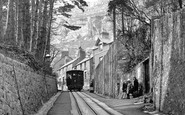
''tram Crash On Tabor Hill''
On Tuesday, August 23rd 1932 there occurred at almost exactly the same spot from which this photo was taken, the most serious runaway and crash that ever ocurred on the line. Car no. 4 broke away from the haulage cable ...Read more
A memory of Llandudno in 1930 by
A Ham Family
My mother and father lived in Evelyn Road - the cul-de-sac opposite the large white house in the distance - mother still there - lived in two of the houses for all her eighty years - married the boy next door (well.. at the top of the cul- ...Read more
A memory of Ham in 1955 by
Saturday Mornings At The Ritz
Me and my brother David would get our breakfast then run down Prospect Avenue North to the bus stop beside the shops and once in Clyde Street at Wallsend bus stops made our way to join the huge queue for entrance to the ...Read more
A memory of Byker in 1955 by
Your search returned a large number of results. Please try to refine your search further.
Captions
9,654 captions found. Showing results 265 to 288.

St Ives is still famous for its cats. In the fishing era, every household had at least one cat, for the very practical purpose of keeping the net cellars free of mice.

St Leonards Pier opened in 1891 at an initial cost of £30,000 as a companion for the pier at Hastings.

The English Civil War ended at Stow-on-the-Wold when the parliamentarian Sir William Brereton defeated the aged royalist Sir Jacob Astley in 1646.

The Domesday survey does not mention a mill at Over. Even if it did, the mill would have been a watermill, as windmills did not appear in England until the mid 1100s.

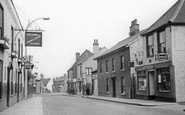
Originally High Street, its approach from the ford across the Roach was via Bull Brow. This old route to Yorkshire was widened in 1897 when the building on the left was demolished.

This view of Waterhead shows the Waterhead Hotel, built to serve the increasing numbers of tourists who were arriving by train at the lakeside station at Bowness, and catching a steamer up the

West Pier, now sadly derelict and awaiting restoration, was enlarged at the seaward end in 1890 to accommodate a larger pavilion.

The advent of the power-loom, however, brought about a decline, but by 1900 new industries had sprung up, including printing at Locher Mill, a laundry at Glentyan Mill and flax and paper mills at Johnstone

Today, its steel descendant carries the A379. At the far end is the church of St Peter, still under construction at this time; it was not finished until 1902.

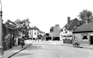
The shops have changed little with the passing years, and at least two still have these distinctively styled awnings. High prams with large wheels were popular at this time.

Using local timber from the woodlands along the estuary, the shipbuilders of Bucklers Hard, who would have lived in these cottages, built at least three of the ships which fought at the Battle of Trafalgar

St Ives harbourside is crowded with holidaymakers, at a time when the town was probably at its peak as a tourist destination.

This little hamlet lies on the River Llugwy, at the foot of Snowdon.

A small boy in a rowing boat gazes at his reflection in the waters of Windermere in this summer photograph.

In this charming photograph, a collie sheepdog marshals a flock of white-nosed Swaledale sheep past the village green at Buckden.

A small boy in a rowing boat gazes at his reflection in the waters of Windermere in this summer photograph.

Bathing is possible along some of the beaches at Cowes, particularly at Gurnard Bay. However, the currents are strong and the shoreline shelves steeply.

By the 1870s, many Lancashire cotton workers received three day's unpaid holiday a year, which was tacked onto a weekend to give a five-day break.

For most of the century there had been daily steamers from Belfast to Bangor, and as the holiday traffic increased the County Down Railway took over the service.

Stand in the corner of the churchyard and you can see that this view of All Saints' Church has hardly changed at all since this photograph was taken.

A classic harbour scene taken at low tide.

Passengers have plenty to look at whilst they await the arrival of their ferry.

The Virginia creeper-clad gritstone walls of the Blue Lion Inn at East Witton, at the eastern entrance to Wensleydale. The inn has served the needs of the villagers for centuries.

The 17th-century mill at Harlow was part of the manor of Harlowbury. It was the main source of power to grind corn and other purposes for the parish at that time.
Places (0)
Photos (0)
Memories (22911)
Books (163)
Maps (7034)

