Places
Sorry, no places were found that related to your search.
Photos
Sorry, no photos were found that related to your search.
Maps
Sorry, no maps were found that related to your search.
Books
Sorry, no books were found that related to your search.
Memories
3,644 memories found. Showing results 311 to 320.
The Old Mill
I remember The Old Mill from 1975, it seems a long time to me. My then husband and I were assistant managers for what was then Schooner Inns Steak Houses. We worked there about 8 months just after we were married, our living quarters ...Read more
A memory of Bexley in 1975 by
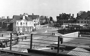
Bus Station
It could be an AEC double decker that is running into the bus station in this picture. I think it could be a little later than 1950 because of the 'embryo' roundabout, but not much because of the single decker leyland on the ...Read more
A memory of Haywards Heath
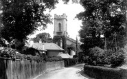
Private School.
The house shown immediately in front of the church was a private school run by Miss Margaret and Miss Cecil Cawse. Both my father and I attended this school.
A memory of Cowes in 0
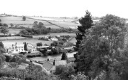
View Down Onto Umberleigh Bridge, Showing Village Square
It is with great interest we see your picture of the village square, showing what is now the Post Office and largest post code sorting office in England. It also shows the Regency Gables Tea ...Read more
A memory of Umberleigh by
Village School
To the left of where the photographer was standing was the junior's playground of the old village school (St Mary and St Margaret's.) In 1963-4 we would have vacated the old buildings and moved into a new building in Southfield ...Read more
A memory of Castle Bromwich in 1965 by
The Hump
Just on the other side of the bridge you can see the footpath leading up and over a mound. This mound was built up in preparation for a projected relief road from the Midland Railway station to the Sheepmarket (on the other side of the ...Read more
A memory of Stamford by
The Town Hall Steps
When I was very young I can remember that my mother used to let me run up and down the town hall steps.
A memory of Llantwit Major in 1975 by
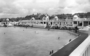
"Hoylake Baths"
I recall happy memories of the Bathing Pool. It had two fountains spurting over fake rocks. We used to climb on these to cool off. In those days the Summers seemed to go on forever. The baths used to attract large attendances in those ...Read more
A memory of Hoylake in 1957 by
Nefyn Beach
The beach cafe shown in the photo entitled 'the anchorage' was owned and run by my aunts, the Misses Miriam and Evelyn Wales, whose father moved to Morfa Nefyn in the late 1800s to take charge of the cable station linked to Ireland. Also ...Read more
A memory of Nefyn in 1940 by
Torpoint Memories
I was born in Tor House Torpoint in 1933. Tor House was purchased by my Grandfather R S G Norgate, Royal Navy, in the early 1900s. My Uncle Dr Robert Norgate inherited the property in 1934. My Brother Joseph and I lived with my ...Read more
A memory of Torpoint in 1943 by
Captions
1,151 captions found. Showing results 745 to 768.

An unusual view of the Abbey Gateway—in the centre—and the bridge over the Cornmill Stream, a tributary of the River Lea, with people relaxing around the broken walls.

The Macclesfield Canal passes through the outskirts of Congleton, complete with an elegant iron aqueduct where it crosses Canal Street, and several attractive bridges.

The Grand Union was created in the 1920s from a network of independent canals linking London with the industrial towns of the West and East Midlands.

Comparing this with D83003, we see that the Plume of Feathers now has bow windows and has been repainted.

One year after this photograph was taken, lines were laid for the new electric tramcars. These continued to run through Tyrell Street until 5 November 1949.

At the outbreak of the Second World War it closed for a short time. The home was handed over to the Royal United Kingdom Beneficent Association in 1953, who modernised it.

The village's name means 'a settlement by the River Cocker'. The village has rows of sandstone cottages and a number of farms. It was self-sufficient in the 19th century.

The South Cliff Tramway offered an alternative means of escape from the beach to the Esplanade; the other way up was by the 224 steps cutting through the Spa Gardens.

This view shows the great width of the street running north to the Green and the church.

This last view of St Mary's Church gives a clearer impression of the relatively unrestored tower stonework.

We are looking south-eastwards from the Yetminster road towards the mediaeval Hamstone cross in a triangle of cobbles (centre), with roads at the junction signed to Sherborne (left) and Chetnole (right

Low Row's intriguing name comes from the fact that this attractive village is strung out for the full distance of a mile along the valley road, which runs close to the river on the northern side of the

This pastoral scene posed by the photographer is charming; it shows the steep village street leading to the cottages grouped around the stocks, church and inn.

Little has changed in this view of the brook running through the estate village. On the left, the old bakery is now augmented by a tea room.

The next four views were taken in the High Street, which runs westward to Hemplands Lane with the site of the railway station beyond.

At the time of the Domesday Book, Halton was the main administrator of the area, and Lancaster was 'under' Halton, which lies three miles north-east of Lancaster.

Worth village stands in the Forest of Worth, east of Crawley, and was a place of pilgrimage. The fine Anglo-Saxon church of St Nicholas was a principal church in pre-Conquest times.

By this date the Royal Hotel has a new glassed-in porch, and now guests can enjoy the fresh sea air without the north-east wind's assistance.

The ponies have just passed the shop which closed a few years ago. Now the Bee Hive Store and Post Office have been built at the end of the terrace and provide service six and a half days a week.

On the left is the post office, run by Fred Maplesden, who was also printer and publisher of the East Grinstead Household Almanack.

From the elevated position of St Andrew's Church we look down the Aire Valley, where now a dual carriageway leads into Keighley.

The older parts of Chipstead village are on the chalk ridge above the dry valley some 150 feet below, along which Chipstead Valley Road runs.

We are looking up Bridge Street past the North Street junction.

We are looking south across the Luxulyan valley. The magnificent Treffry Viaduct was built in 1842 to carry a tramway and an aqueduct.
Places (0)
Photos (0)
Memories (3644)
Books (0)
Maps (0)

