Places
17 places found.
Those places high-lighted have photos. All locations may have maps, books and memories.
- Bridge End, Oxfordshire
- Bridge End, Lincolnshire
- Bridge End, Essex
- Bridge End, Bedfordshire
- Bridge End, Clwyd
- Bridge End, Warwickshire
- Bridge End, Surrey
- Bridge End, Durham (near Frosterley)
- Bridge End, Northumberland (near Hexham)
- Bridge End, Hereford & Worcester (near Tirley)
- Bridge End, Hereford & Worcester (near Bosbury)
- Bridge End, Shetland Islands
- Bridge End, Cumbria (near Carlisle)
- Bridge End, Northumberland (near Hexham)
- Bridge End, Devon (near Kingsbridge)
- Bridge End, Devon (near Sidmouth)
- West End, Yorkshire (near Pateley Bridge)
Photos
40 photos found. Showing results 1,121 to 40.
Maps
520 maps found.
Books
2 books found. Showing results 1,345 to 2.
Memories
1,925 memories found. Showing results 561 to 570.
My Childhood
You caught newts in the reservoir, just off Greig Park....down at the trenches....apples and pears in the berries...an old garden down Haughmill Lane...who remembers the barrel bridge....and the tennis courts?
A memory of Balcurvie in 1955 by
Baring Road
I was born at Mayday Hospital. My parents still live in Baring Road and my mother has lived there from the age of 13, as my grandmother had the house before they did. I vividly remember playing 'up and down the road.' It is so sad ...Read more
A memory of Addiscombe in 1955 by
Ive's Paper Shop
I was a paper boy for Ives when the Father was in charge and then at the end his son Brian? took over. I did not have many papers to deliver but the round started by the Junction Pub and cottages by the Canal along the towpath up ...Read more
A memory of Southall in 1955 by
Stockbridge Station, Station House.
My grandfather and grandmother, Mr William Edward Massey known as (Bill) and Rose Massey, with Jack and Ruth Massey lived at Station House, Stockbridge Station. Does anybody remember the above and have any ...Read more
A memory of Stockbridge in 1955 by
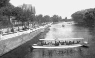
Working Memories.
I was the main weekday driver of the launch photographed during the student holiday periods of 1955-1958. When I drove it, the name was 'Silver Stream'. It was the largest of a set of three electric launches which carried paying ...Read more
A memory of Bedford in 1955 by
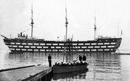
Cadet On Worcseter
I was a cadet from 55 to 59 in Main Division. Went back recently, not a ship on the river and a huge bridge upstream
A memory of Greenhithe in 1955 by
Early Schooldays
My memories of Byfield, where I lived on the brand new council estate, in Lovett Road, are idyllic. I was there from age 6 to 10, then we moved to York. We children had to walk what seemed like miles, in all weathers, to the ...Read more
A memory of Byfield in 1954 by
George Maddison
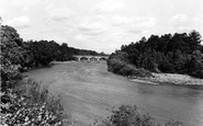
thanks to this photograpgh i have identified a photograph of my late father taken in 1954 we all thought it was the hexham bridge but now know it is the bywell bridge by the number and type of arches over the river thanks philip maddison
A memory of Bywell in 1954 by
Holidays With Grandad
Thank you for showing the photo of Bank Houses, the house on the right was where my grandad lived and I spent a lot of very happy holidays there. His garden was aways full of lovely things to eat and as I lived in an ...Read more
A memory of Somersham in 1954 by
Aston Terrace
I was born in Aston Terrace in 1954 and remember running to the bridge to see the steam trains and also the big slag heap that my brothers used to slide down. I also remember the gas man that used to light the street gas lamps outside ...Read more
A memory of Aston in 1954
Captions
1,770 captions found. Showing results 1,345 to 1,368.

Aveley is a small village situated a few miles to the east of Rainham and close to the Thames and Essex Marshes.The parked bicycles on the right, no cars to be seen and the crowd waiting for the bus

The bridge started to show its age soon after our photograph was taken, and by the mid 1960s it was declared unsafe.

This seven-arched road bridge was built in 1775 to carry the Great North Road over the river. It replaced earlier crossings dating from 1190.

The far, tall building marks Bridge Street, the spot where the first bridge upstream was located.

Just along the canal from Bridge 104, the boat is emerging from a turning point in the canal basin.

The bridge immediately beyond the lock used to take a railway into Pirbright army camp, just behind the trees to the right.

Bathpool is now very much a suburb of Taunton, with the spread of the Somerset town on one side and the M5 motorway on the other.

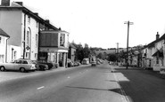
An RAC patrolman guides an early Austin saloon around the junction of Church Street and the High Street, as a 408C double-decker bus emerges from the top of Bridge Street.

The rustic bridge parapets over the brook also look like John Hicks's work.

The rustic bridge parapets over the brook also look like John Hicks's work.

The bus in the distance has just passed Ford Bridge. Once called Stratford (the `street ford`), this was where the Roman road crossed the River Chelmer.

A packed steamer is kept firmly alongside the pier as the Master on the bridge plots her progress carefully. She is either about to put warps ashore or has just taken them aboard.

At the time of the herring fleet's arrival from Scotland, the boats completely filled the harbour, and it used to be said that one could walk right across the river without using the
Just along the canal from Bridge 104, the boat is emerging from a turning point in the canal basin. The bank to the right, where the car is parked, now houses a boat hire firm, Castle Narrowboats.

Mayburgh Henge is one of a group of three prehistoric monuments near Eamont Bridge.

In this view the medieval bridge is on the left and the former Crepe Mill of 1814, now the Dulverton Laundry, dominates the centre.

The bridge was built to designs by Alexander Galloway, Rector of Kinkell, started in 1521 and widened by John Smith, 1840. The upstream facings were removed and replaced on the widened structure.

The Quay c1955 Stand on the toll bridge by Eling Tide Mill, where this photograph was taken, and you will see that the tall chimney on the left has gone, as have many of the other industrial

This city (with the smallest cathedral in Britain) stands above the confluence of the River Clwyd and its tributary the Elwy.

The `Star Inn` on the left is being given a fresh lick of paint in this view from the railway bridge.

The five-arch later 19th-century red-brick bridge still rather pompously carries a narrow roadway across the pond in the south west angle of the Heath.

A packed steamer is kept firmly alongside the pier as the Master on the bridge plots her progress carefully. She is either about to put warps ashore or has just taken them aboard.

Gretna stands on the Scottish/English border, and so it became popular for runaway marriages of English couples following the passage of Lord Hardwicke's act in 1754.

This important mid 15th-century bridge at the lowest crossing point of the River Fowey links the two parts of Lostwithiel.
Places (17)
Photos (40)
Memories (1925)
Books (2)
Maps (520)

