Places
Sorry, no places were found that related to your search.
Photos
6 photos found. Showing results 161 to 6.
Maps
862 maps found.


Books
2 books found. Showing results 193 to 2.
Memories
1,131 memories found. Showing results 81 to 90.
Entertainment In The 1950''''''''s
Uxbridge was blessed with 3 cinemas; The Odeon, the Regal and the Savoy (the oldest of the three it stood on the corner of Vine St and the High St). The Odeon, I think, had the biggest productions as it had a wider ...Read more
A memory of Uxbridge by
Pottrs Bar Fur Stores 1959
I was born in Potters Bar in 1957, my grandad owned Potters Bar Fur Stores, his name was David Kantor. I used to visit as a little girl, it smelt of moth balls, and my jewish aunties, Sadie and Fay worked on the ...Read more
A memory of Potters Bar by
The Carlton Ballroom
It was a must in the 1960's. The Carlton was in the High Street near the post office, a few steps were at the front, leading to the entrance and it was always packed. They had a bar upstairs where you stood drinking looking ...Read more
A memory of Slough
Michael Cole Calling
I lived in Langdale Gardens. From 1950 to 1963 then got married and moved away, went to Ayloff school then to Sutton’s secondary. As teenagers we used to drink at Hornchurch pub and a disco round the corner. Sometimes me and ...Read more
A memory of Elm Park by
War Baby Head Banger 1944
I was born in September 1939 just after WW2 had started...My parents who had their house in Waldridge Road decided to move into West Lane to be near my Grandparents while my Dad who was in a reserved occupation was ...Read more
A memory of Chester-Le-Street by
Buckingham Arms
I was 10 when I first stayed. with my parents at the Buckingham Arms in the summer of 1965, we returned again the next year. It was run by Jim & Brenda Horrell and their young son Tony. We were awoken every morning at an ...Read more
A memory of Taddiport by
Litchfield Gardens Hall Family
I was born in 58 Litchfield gardens in 1949 and went to St Andrews juniors and still remember the air raid shelters in the play ground and being there when they were knocked down. I took a trip 'down memory lane' some ...Read more
A memory of Willesden by
My Birthplace
I was born in Seer Green over 60 years ago. It has,and always will be my first home. I have lived abroad for the past 30 years. I return to S.G. at least once a year to visit my mother and sister and enjoy the nostalgia of walking ...Read more
A memory of Seer Green by
Parham House
I was sent there at the age of 5 in 1951. It was run by Mrs Russel known as Auntie Barbara and her husband Uncle Max who kept pigs. I stayed there for holidays as well and when I went to boarding school at the age of 8 I returned for ...Read more
A memory of Saxmundham by
Inferno Club And Twisted Wheel
Dear Sir/Madam, Two days ago I uploaded a memory of the Inferno Club and Twisted Wheel café bar in Welling. I am really disappointed to discover this has not appeared in your archive. Perhaps you would be kind enough to let me know why. Thank you, Bernard Schofield
A memory of Welling
Captions
252 captions found. Showing results 193 to 216.

As the suburban semi-detached house with its timbering and Tudor detailing reflected the Englishman's home as his castle, so with the contemporary pubs.

This, the northern gate, stands on the site of the Roman Porta Principalis, the gateway of Eboracum. The barbican was demolished in 1835. The name Bootham derives from Buthum, 'at the booths'.

Chertsey was once the town at the gates of one of the most powerful abbeys in England.

Here we are at the junction of Cannon Street and the approach to the new London Bridge; the street was opened by King William IV in 1831, and named after him.

In 1891 a fire caused considerable damage to the fabric of the building, and the impression from the photograph is of a complete rebuilding soon after that date.

A striking building in the High Street is The Queen's Head Pub, mainly of the 17th century, with its welcoming atmospheric bars.

With five roads feeding into it, this famous junction (close to the access to the Queensway Tunnel under the River Mersey) is one of the busiest in the region.

This view shows the village spread out on the Fylde plain, an area prone to flooding. On the hill stood Preesall village school.

This rare shot shows the old turnpike cottage (left) at Holme Toll Bar, before the corner was cleared for road widening, looking westwards from Stoborough to East Holme.

The shop extension filled with shoes and boots is now filled with all manner of things for pets. On the other side of the road was a garage, which is now the Job Centre and the Sue Ryder shop.

The Stanhope Memorial stands in the middle of the space where the market is held twice a week.

No parking restrictions were in place at this date, and the Market Place served as the bus station. Car ownership was still a minority activity, despite the number of cars we can see here.

This part 16th-century timber-framed building is named after the Wylyot or Williot family, who held the manor in the mid 1300s as an outlier of the manor of South Mimms.

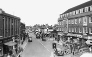
WH Smith is the only business surviving on the same premises today, although with a modern shopfront and a plain blue and white sign rather than the old wrought iron one seen here.

The dry dock served by boat builders and repairers has half solid swing gates maintaining the level of the water.

The flat-roofed Foreshore Centre (left) contained a first-aid room as well as an information bureau, left luggage office and lost children's shelter.
WH Smith is the only business surviving on the same premises today, although with a modern shopfront and a plain blue and white sign rather than the old wrought iron one seen here.
WH Smith is the only business surviving on the same premises today, although with a modern shopfront and a plain blue and white sign rather than the old wrought iron one seen here.
The shop extension filled with shoes and boots is now filled with all manner of things for pets. On the other side of the road was a garage, which is now the Job Centre and the Sue Ryder shop.
The Stanhope Memorial stands in the middle of the space where the market is held twice a week.

By now the impact of the alterations to the Market Place and Church Street of 1962/63 are clear.

At the time of this photograph, the fun fair belonged to Billy Butlin, and the Figure 8 was an exciting ride fifty years ago.

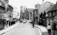
We can also see St Luke's Church at the top of the street. This church was designed in 1802 by John Foster Senior.

The Teifi begins its journey to the sea 70 miles away; it provided an inland route for the Normans to service the castles of Cardigan and Cilgerran.
Places (0)
Photos (6)
Memories (1131)
Books (2)
Maps (862)

