Places
26 places found.
Those places high-lighted have photos. All locations may have maps, books and memories.
- Cemmaes Road, Powys
- Six Road Ends, County Down
- Road Weedon, Northamptonshire
- Severn Road Bridge, Gloucestershire
- Roade, Northamptonshire
- Berkeley Road, Gloucestershire
- Harling Road, Norfolk
- Road Green, Devon
- Builth Road, Powys
- Cross Roads, Yorkshire
- Steele Road, Borders
- Cross Roads, Devon
- Four Roads, Dyfed
- Road Green, Norfolk
- Biggar Road, Strathclyde
- Clarbeston Road, Dyfed
- Five Roads, Dyfed
- Eccles Road, Norfolk
- Grampound Road, Cornwall
- Morchard Road, Devon
- Wood Road, Greater Manchester
- Four Roads, Isle of Man
- St Columb Road, Cornwall
- Clipiau, Gwynedd (near Cemmaes Road)
- New Road Side, Yorkshire (near Silsden)
- New Road Side, Yorkshire (near Cleckheaton)
Photos
14,329 photos found. Showing results 2,561 to 2,580.


Maps
476 maps found.
Books
5 books found. Showing results 3,073 to 5.
Memories
11,058 memories found. Showing results 1,281 to 1,290.
Evacuation To Woolavington
My family (name of Marsh) evacuated to Woolavington to escape the continual bombing of London. We lived in 2, Church Street and my aunt and her family lived in No 1. At the vicarage, which I believe was just over ...Read more
A memory of Woolavington in 1940 by
Rainbow Trout
Now a resident of Australia, I still have fond memories of catching a train to Kildale as a 13 year old and walking over the moors, and later, cycling from Thornaby through Commondale and back home. I remember laying down near a ...Read more
A memory of Kildale in 1963 by
School Days
First school London Road Infants, a short time in Scotland and then the Church Infants, each school day walking from Theatre Street (two doors up from 'The Cherry Tree') through the market place and down Church Street. I moved on to ...Read more
A memory of Dereham in 1940 by
Such Great Holidays!
I remember as a child the great holidays in the 60s on the beaches at Holland. We hired a beach hut for 7/6 a week near the deck chair and paddle float hire. Who can forget the pretty girls who pushed the ice cream ...Read more
A memory of Holland-on-Sea in 1960 by
I Lived There ....
My parents were landlords of the Littleton Arms in the early 1960s era. I was around three years old or so then. Can remember the Saturday nights when bands played down in the bar, wooden beer barrels large and small being delivered ...Read more
A memory of Walsall in 1962 by
I Am The Boy On The Bike!
I am the lad on the bike in this photo. I remember the photographer standing in the road with a camera on a tripod. I know for def it was a Saturday morning because it was my job to fetch the bread from Stoppards the butchers/bakers every Saturday morning.
A memory of South Normanton by
Childhood In Addlestone
I have many memories of Addlestone having lived there from 1940 to 1964. My family lived in Bourneside Road, at the far end was Coxes Lock Mill and the mill pond. We knew almost everybody that lived on Bois Hall estate. I ...Read more
A memory of Addlestone by
Dittisham Road,Mottingham
Did anyone live in Dittisham Road, Mottingham from about just after WW2 until about 1985? My grandparents, Harry & Rose Bass, lived in this road. Anyone remember them? Get in touch please. Thank you.
A memory of Mottingham in 1960 by
Orsett Village
I was born in Orsett at the Bothy Prince Charles Avenue in 1955. I Lived at the Armary (Orsett Hall) until 1965, when our family moved to Rectory Road in the village. The Cuthbert's have a long history in Orsett with my mother and ...Read more
A memory of Orsett in 1955 by
Mile Oak Portslade 1938 To 1950
Hello, I was one of the few children who lived in Mile Oak Road and and also played on Broomfields Farm, we lived at no 222 which was the second to last house before the road dropped down the hill to Mile Oak. The ...Read more
A memory of Mile Oak in 1947 by
Your search returned a large number of results. Please try to refine your search further.
Captions
5,036 captions found. Showing results 3,073 to 3,096.

Construction of the three-mile road provided much-needed employment for local men in the depression that had followed the end of the Napoleonic Wars.

The horse and cart are approaching the old packhorse bridge, which was later to be by-passed by a new road bridge.

Where the bus mean- ders westward, the dual carriageway of Balkerne Hill removed a number of buildings on each side of the road on its noisy way to the Southway roundabout, cutting Crouch

Until mid-Victorian times, this part of the road, known now as Greenhill, had been called New Well Hill. Here, we are looking towards the Green at the turn of the century.

Danbury sits at the top of a long uphill haul on the road from Chelmsford to Maldon. Before the Navigation was opened, this was the main thoroughfare between the two towns.

They are set slightly below road level, and are reached by steps down. The thatch remains in excellent condition, and so do the porches. The picket fence has been extended to replace the hedging.

Laindon School—formerly Laindon High Road School—opened in 1928.

It was essentially a wool town, and its great market was held in the wide stretch of road we see here.

Robins Brothers, not content with filling their windows to bursting, have extended out on to the pavement and into the road.

Traffic comes to a standstill for this large flock of sheep being driven along the main road.

The road to Brynmawr winds around the hillside from the village of Gellifelyn, on the right.

Petworth to Guildford main road.The church of St John Baptist was rebuilt in 1877; it has a strange-looking font dated 1662.The Half Moon is a 16th-century inn.The Swan Inn can be seen down the road
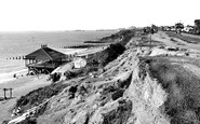
Here we see National Trust shingle and cliffs at the end of Beach Road, with the buildings (top right) comprising the Burton Cliff Hotel.

Pictured here is the junction of London Road (the A31) and Church Lane. The house on the corner, known as The Beeches, was advertised for auction in 1920.

Great swathes of countryside were cut through to make roads and roundabouts.

We are looking up the steep incline of Bank Road, with the fondly- remembered Ormes department store at centre right.

There were plenty of fishing boats in what used to be known as Beer Roads. The rocky promontory, East Ebb, divided Seaton from Beer and kept the two places apart.

The original spa building still exists in the road to the left of the picture.

Cyclists and pedestrians occasionally found the tram- lines an extra hazard on Dorset's rough and ready roads.

The stocks can be found at the junction of Blackmore Road and Stocks Lane.

This was the main London-Colchester road. Stage-coaches used to change horses at The Plough (right). The pub is the one feature of this scene to stay relatively unchanged.

On the opposite side of the road a parade of shops has replaced the undertaker`s and surrounding houses. The village school beyond has given way to Waitrose.

There is, of course, another Wheatsheaf further along the road; it had once been a pair of cottages, but they were converted to a beer house in the 1880s.

The barn just up the road was erected in 1742; despite its being in a poor condition today, efforts are being made to restore it for use as a dwelling.
Places (26)
Photos (14329)
Memories (11058)
Books (5)
Maps (476)

