Places
17 places found.
Those places high-lighted have photos. All locations may have maps, books and memories.
- Bridge End, Oxfordshire
- Bridge End, Lincolnshire
- Bridge End, Essex
- Bridge End, Bedfordshire
- Bridge End, Clwyd
- Bridge End, Warwickshire
- Bridge End, Surrey
- Bridge End, Durham (near Frosterley)
- Bridge End, Northumberland (near Hexham)
- Bridge End, Hereford & Worcester (near Tirley)
- Bridge End, Hereford & Worcester (near Bosbury)
- Bridge End, Shetland Islands
- Bridge End, Cumbria (near Carlisle)
- Bridge End, Northumberland (near Hexham)
- Bridge End, Devon (near Kingsbridge)
- Bridge End, Devon (near Sidmouth)
- West End, Yorkshire (near Pateley Bridge)
Photos
40 photos found. Showing results 301 to 40.
Maps
520 maps found.


Books
2 books found. Showing results 361 to 2.
Memories
1,928 memories found. Showing results 151 to 160.
Sunny 1950''s Sunday Mornings
I have many memories about the old St Mary's Church. Until I started thinking of them I realised that I have not got one involving a rainy day apart from when my Grandad was buried in the churchyard. He was ...Read more
A memory of Clayton-Le-Moors in 1954 by
A History Lesson
I have lived nearby for 10 years and this place eluded me for a while. Tancreds Ford is still a ford but the bridge is the modern equivalent. The reason I am posting this is because it was on the old smugglers route! Contraband ...Read more
A memory of Frensham by
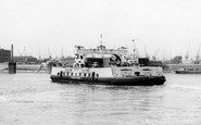
Woolwich Ferry
There has been a ferry at Woolwich for many centuries but the people of Woolwich complained in the 1880s that West London had free access across the River Thames by bridges so why couldn't they have free travel? The river was too ...Read more
A memory of Woolwich by
Evacuee
I was evacuated from London to Oxford with Burlington School on 1st September 1939. At first we had our lessons in the old Milham Ford School premises but after a few weeks transferred to the new school in Marston where we shared the ...Read more
A memory of Oxford in 1940 by
Cappels Shop
I remember going into Cappels shop in the late 1970s and buying kali and liquourice. I also remember going down to Coach bridge, swimming with my friends, and a man called malcolm used to come over on his penny farthing, good times were had by all.
A memory of Nether Heyford by
Happy Days
I was born in 1953 and lived in Nelson until 1978 when I moved to Scotland with my husband. I've lived in Hampshire for 26 years now. I used to live in High St and from the early 60s in Ashgrove Tce, by the bus station. The ...Read more
A memory of Nelson by
Family Evenings Out.
I cannot remember the exact years, about 1950, when my Mother and Father used to take me and my cousin for a walk from our house at Lensbrook Cottage through six fields (which is a public footpath), and arrive ...Read more
A memory of Blakeney in 1950

Yr Gof Cynwyl Around 1960
Yr Gof Cynwyl. (I’m no verra guid at the Welsh I doubt) It would be around 1960 that I used to get jobs done at the Cynwyl blacksmith shop. Mr Jones was a good man although crabby at haymaking time. I went there ...Read more
A memory of Cynwyl Elfed in 1960 by
My Grandad Humphreys Thomas John1875 1965
Grandad Humphreys, he was a carpenter making and restoring the Lockgates on the Montgomery Canal. Born in Welshpool 1875-1965. I remember the little trains running across Church Street as a boy of 8 ...Read more
A memory of Welshpool in 1954 by
My Memories Of Mossband
I lived with my parents at 28 The Green, Mossband from around 1942 (when I was one year old) until 1949, when my Father, Edward Lovie (a WD constable) died from throat cancer. My memories are all fairly traumatic and ...Read more
A memory of Mossband Ho in 1940 by
Captions
1,770 captions found. Showing results 361 to 384.

Tilford is situated where the south branch of the River Wey meets the main River Wey, each branch crossed by a medieval bridge.

The Whitchurch Tollbridge Company was established in the 18th century: a distinctive Victorian bridge of lattice ironwork spans the Thames between Whitchurch and Pangbourne, one of only two remaining toll

The bridge was constructed to give road access to the railway station built on the St Martin's side of the river in 1846; it was designed in the same Gothic Revival architectural style, and the parapet

The 'longest and fairest' bridge in Cornwall crosses the upper part of the Camel estuary, seen here at high tide.
The Fraternity of the Holy Cross built the two bridges, the causeway across Nag's Head Island, and then the long causeway that runs south for over a thousand yards across the flood plain to Culham

Cock Bridge takes Whalley Road across the River Calder (now much cleaner than it used to be) and links Great Harwood and Whalley.

High Sweden Bridge is a picturesque packhorse bridge over the Scandale Beck between High Pike and Snarker Pike (there is a Low Sweden Bridge lower down the valley).
Here we see St John's College Old Bridge, originally conceived by Wren, but brought into being in 1712 by Robert Grumbold.

Having Avenham Park in the background does enhance the pleasure of a walk over the bridge. Avenham Tower can be seen in the trees to the right, and the paths lead away to Frenchwood.

The seven-arched bridge is made from sandstone. It was designed by John Gwynne, a founder member of the Royal Academy, and constructed in 1771.
High Sweden Bridge is a picturesque packhorse bridge over the Scandale Beck between High Pike and Snarker Pike (there is a Low Sweden Bridge further down the valley).

Stopham Bridge has long been considered one of the finest and most striking of medieval bridges in the country. Dating back to 1309 and rebuilt in 1403, the bridge is now preserved.

The bridge was not always as level, strong and wide as this.

The bridge was built by the Bishop of Salisbury around 1240 to facilitate trade between the new city and the south: the Cathedral spire can be seen in the background.

This bridge, like the one at Bewdley, was designed by Thomas Telford; it replaced an old ferry and ford. It is a single-span iron bridge.
High Sweden Bridge is a picturesque packhorse bridge over the Scandale Beck between High Pike and Snarker Pike (there is a Low Sweden Bridge lower down the valley).

Teddington was earlier called Todynton and Tuddington.

In 1852 a suspension bridge was built over the Dee to link the suburb of Queen's Park with the Groves on the north side of the river. In the distance can be seen the mills and the Old Dee Bridge.

The halfpenny toll on the original Blackfriars Bridge caused riots, and in 1780 angry protesters burned down the toll-house.After a succession of expensive repairs a replacement was suggested, and
 c.1965, Warrington")
Known locally as 'The Cantilever', this high level fixed bridge provides a welcome escape route when the Knutsford and London Road swing bridges are closed.

This was the latest of many wooden bridges to span the River Stour at this point on the main route from Essex (right) into Suffolk.

Having Avenham Park in the background does enhance the pleasure of a walk over the bridge. Avenham Tower can be seen in the trees to the right, and the paths lead away to Frenchwood.

Thomas Telford's stately bridge over the Severn was completed in 1801, a delightful mixture of stone and cast iron.
The bridge was constructed to give road access to the railway station built on the St Martin's side of the river in 1846; it was designed in the same Gothic Revival architectural style, and the parapet
Places (17)
Photos (40)
Memories (1928)
Books (2)
Maps (520)

