Places
36 places found.
Those places high-lighted have photos. All locations may have maps, books and memories.
- Bridgend, Mid Glamorgan
- Porthcawl, Mid Glamorgan
- Maesteg, Mid Glamorgan
- Pontycymer, Mid Glamorgan
- Bridgend, Dyfed
- Bridgend, Strathclyde
- Pencoed, Mid Glamorgan
- Aberkenfig, Mid Glamorgan
- Nant-y-moel, Mid Glamorgan
- Blackmill, Mid Glamorgan
- Nottage, Mid Glamorgan
- Merthyr Mawr, Mid Glamorgan
- Bryncethin, Mid Glamorgan
- Bridgend, Devon
- Newton, Mid Glamorgan
- Wig Fach, Mid Glamorgan
- Ogmore Vale, Mid Glamorgan
- Caerau, Mid Glamorgan (near Maesteg)
- Sarn, Mid Glamorgan
- Tondu, Mid Glamorgan
- Mawdlam, Mid Glamorgan
- Coity, Mid Glamorgan
- Llangynwyd, Mid Glamorgan
- Kenfig Hill, Mid Glamorgan
- Cefn Glas, Mid Glamorgan (near Bridgend)
- Llanilid, Mid Glamorgan (near Bridgend)
- Candleston Castle, Mid Glamorgan
- Glynogwr, Mid Glamorgan
- Abergarw, Mid Glamorgan
- Pant-yr-awel, Mid Glamorgan
- Price Town, Mid Glamorgan
- Brynmenyn, Mid Glamorgan
- Bridgend, Strathclyde (near Kirkintilloch)
- Bridgend, Tayside (near Kirriemuir)
- Bridgend, Lothian (near Linlithgow)
- Bridgend, Cumbria
Photos
193 photos found. Showing results 101 to 120.


Maps
520 maps found.


Books
2 books found. Showing results 121 to 2.
Memories
349 memories found. Showing results 51 to 60.
The Chapels
In the 1940s and 50s social life in Cwmtwrch was centred on the chapel and public house. There were eight active chapels, each with its own distinctive architecture, and representative of the major non-conformist denominations ...Read more
A memory of Lower Cwm-twrch in 1940 by
The Shakey Bridge
My mother left Yorkshire with me in 1945 when I was four years old. She worked for a Mrs Curzon at Arrochar house in Rothiemay as a cook and general help. I think the owners were titled people. I remember ...Read more
A memory of Rothiemay Crossroads in 1945 by
Earith Was In Huntingdonshire And Still Is
I was born in St Ives in 1939 but lived in Earith at what is now number 43. Next door was my Grandad's grocer's shop - Bert Russell. I moved to Peterborough in 1958 where I still live in Werrington ...Read more
A memory of Earith in 1940 by
Terrified By White Masses
Hi I was taken to the upper Rhondda valley (Tynewydd) by my mother in 1940 , I was some 9 yrs old. I went to school both primary and secondary (Treherbert boys school). I had lots of cousins. Myself and my cousin ...Read more
A memory of Blaengwynfi in 1940 by
Hampton Wick Magolia Resturant
I'm christophers sister Valerie dunn was baggott.we loved living in Hampton wick .it was fun having dinner in the restaurant -we could order anything we wanted..i nearly allways had sausage beans and chips.we use to ...Read more
A memory of Hampton Wick by
A Trip Down Memory Lane
I am very pleased to have found this site, I was on Friends Reunited but it closed. I was born in 19 Chester Street in 1947, went to Lawson infants school, Smeaton Street and Middlesbrough Tech. My sister, Pat, grew up ...Read more
A memory of Cargo Fleet by
Coming Into Halifax Via North Bridge
As a child we used to return in the car down the hill towards North Bridge and the game was to be the first to spot Wainhouse Tower amongst all the other mill chimneys there were at that time (late 50s/early ...Read more
A memory of Halifax by
Barton Swing Bridges Road And Canal
This picture shows both the Barton road bridge and the swing bridge carrying the Bridgewater Canal across the Manchester Ship Canal in the 'open' position. I used to visit this site as a child when ...Read more
A memory of Barton Upon Irwell by
Dogdyke County Primary School
Being born in 1957 I attended Dogdyke County Primary school from 1962 whilst living with parents in Witham Drive, Chapel Hill. We used to walk or cycle to school in those days. Shortly after then we moved to ...Read more
A memory of Dogdyke in 1962
Machen Trethomas Bedwas 1960
Hello Diane, How are you?I was born and brought up in Machen, 1 Brynhyfryd Terrace. Moved to Trethomas after marriage, lived in Lower Glyn Gwyn (1954) .The Glue Pot you talk about was the Lewis's Hotel (pub), do you ...Read more
A memory of Machen by
Captions
154 captions found. Showing results 121 to 144.

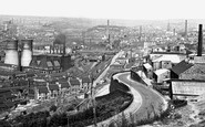
An iron works was opened in 1837, but it was the discovery two years later of ironstone deposits at nearby Shotley Bridge, and the opening of coal pits during the 1840s, that sparked off the town's growth

The masts of sailing ships are visible beyond the bridge, and a fine collection of rowing boats can be seen around the boathouse.

This bridge is a railway bridge, and is now part of the west coast main line. Another railway bridge (to Blackburn) can be seen in the distance.
But the site of the old bridge and the cottages in this photograph can still be seen nearby.

Furnace Bottom is one example, while Pig Street is so named because pig iron was transported that way to the Severn Railway Bridge, and then by rail to Gatcombe, Bristol and beyond.

Anchor Wood is a narrow band of trees with a pleas- ant walk overlooking marshy ground downstream of the Long Bridge and at the foot of Sticklepath.

The canal bypasses Fleckney on its eastern side; the photograph looks north east across Second Lock, towards Kibworth bridge and Bridge House, as the waterway winds towards Newton Harcourt

Taken opposite Lower Quemerford Mill, this view shows Marden Bridge and the Mill House on the right.

This splendid branch railway ran from Ulverston to Newby Bridge and Lakeside at the foot of Windermere.

This was not only a freight line for the reservoirs, but also a passenger railway between Pateley Bridge and Lofthouse from 1901 to 1929.

Normal operating practice is for the bridge and aqueduct to be swung clear of the MSC approximately 30 minutes before a ship is due to pass through.

A lane leads left to the church and manor house, and to the right is Burycroft, which leads to the medieval bridge and then Abingdon.

Roads pass by leading to Dunsop Bridge and Slaidburn. The young John Bright attended school here to improve his knowledge and physique.

When Queen Elizabeth II came to the throne in 1953, the village erected a Coronation Bridge and laid out Coronation Gardens, which we can see here.

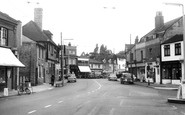
The photograph gives an unusual perspective in that the exit from the bridge and the High Street beyond appears to be restrictive for both traffic and pedestrians.

That bridge was joined in the 1960s by the dual carriageway box-girder road bridge and footway alongside.
Roads pass by leading to Dunsop Bridge and Slaidburn. The young John Bright attended school here to improve his knowledge and physique.

Nag's Head Island is in the centre with its hotel fronting the bridge, and Stevens's Boatyard are the white buildings to the left.

The bridge on the right is known as Burford Bridge and that on the left is Abingdon Bridge.

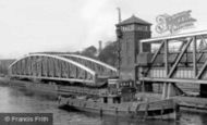
Both the new high-level road bridge and the old transporter can be seen on our photograph.

The signpost still points the way to Windermere and Bowness, Kendal and Lancaster, and Bowland Bridge and Winster Church.

Once a year the village would be packed with visitors; they came to lean over Paythorne Bridge and watch the salmon leaping in the River Ribble.

The town is now by-passed by both the A1 Great North Road, which crossed the bridge, and the Fosse Way (the A46).

A heavy storm in 1877 battered the bridge, and we see it in its repaired state in photograph 36076 (above).
Places (108)
Photos (193)
Memories (349)
Books (2)
Maps (520)

