Places
36 places found.
Those places high-lighted have photos. All locations may have maps, books and memories.
- Pentre-cwrt, Dyfed
- Pentre Halkyn, Clwyd
- Pentre, Mid Glamorgan
- Ton Pentre, Mid Glamorgan
- Pentre, Powys (near Llangynog)
- Pentre, Powys (near Guilsfield)
- Pentre, Powys (near Bishop's Castle)
- Pentre, Dyfed (near Pontyates)
- Pentre, Powys (near Newtown)
- Pentre, Clwyd (near Mold)
- Pentre, Clwyd (near Ruabon)
- Pentre, Shropshire (near Chirk)
- Pentre, Clwyd (near Hawarden)
- Pentre, Clwyd (near Chirk)
- Pentre, Clwyd (near Ruthin)
- Pentre, Clwyd (near Mold)
- Pentre, Shropshire (near Oswestry)
- Pentre, Powys (near Welshpool)
- Pentre, Clwyd (near Mold)
- Pentre, Shropshire (near Forton)
- Pentre Broughton, Clwyd
- Pentre Gwynfryn, Gwynedd
- Pentre Maelor, Clwyd
- Pentre-clawdd, Shropshire
- Pentre Galar, Dyfed
- Pentre Llifior, Powys
- Pentre-cefn, Shropshire
- Pentre-Gwenlais, Dyfed
- Pentre-Poeth, Dyfed
- Burntwood Pentre, Clwyd
- Pentre Berw, Gwynedd
- Pentre Hodre, Shropshire
- Pentre Llanrhaeadr, Clwyd
- Pentre-celyn, Clwyd
- Pentre Cilgwyn, Clwyd
- Pentre Morgan, Dyfed
Photos
98 photos found. Showing results 1,721 to 98.
Maps
316 maps found.
Books
2 books found. Showing results 2,065 to 2.
Memories
1,253 memories found. Showing results 861 to 870.
Cookridge School And Perkins Farm
I was born in 1946 and spent the first 3 years living in a curved un-insulated "nissen" hut next to the gunsight in Adel. We then moved to 71 Raynel Way in 1949. I attended Cookridge School and used to walk up ...Read more
A memory of Cookridge in 1949 by
Memories Of The Dulas Arms
My name is Dilys Bandtock nee Williams, what a shock I got this morning while browsing my computer to come across this site Wow! Explore my past, gee I was born here in 1938 in Raynes Cottages, Llysfaen Station in the ...Read more
A memory of Llanddulas in 1943 by
Bank Hall School
Bank Hall School 1977 to its close in 1980, I remember the head, Mr Brennan, and his wife living in the house just next to the the main house, also Peter Lucas, Pete Denver, Mr Lowery. There were a few women there at ...Read more
A memory of Chapel-en-le-Frith by
Years Gone By 1960s 1970s Part 1
Lynette Carter (nee) Evans I was born in Glossip Terrace Hospital Splott Cardiff. My family and I first moved to Heol Cynllan Road, Llanharan when I was just over 2 years old. We lived with my Aunty Fanny and ...Read more
A memory of Llanharan in 1964 by
Walsall, The George Hotel C1973
My friend and I, still best buddies to this day, used to go to The Mayfair every Saturday night. We loved Motown and Northern soul and still do. Then we progressed to The Femina, at the back of The George. The name ...Read more
A memory of Walsall in 1973
My Younger Days In Grove Place
I used to live in Grove Place which of course is no longer there. I remember Mrs Jones fish and chip shop a couple of doors from me where you could get a bag of crackling (yum). Then round the corner in Western Road ...Read more
A memory of Ealing by
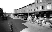
Victoria Buildings And Freshfield Station
This picture shows clearly the row of small shops that greeted you as you left Freshfield Station on your walk to the village. Bowers (or was it Cross's) the bakers next to the railway track, baked ...Read more
A memory of Freshfield in 1955 by

1947 Onward
I also remember there was a slaughter house on (think it was) Blackwater Street, or it could have been Toad Lane. There was a pub across from it called Dusty Miller that was next door to Marsh's cafe. I too remember the shop on ...Read more
A memory of Rochdale in 1959 by
Building
My father worked on the site building Westbury Shopping Centre. I remember there being a full size model of a dalek in the dry cleaners that used to be on one end of block. Used to be able to get inside it and pretend to be a dalek, which was great fun for an 8 year old.
A memory of Westbury by
Croydon, Shirley & New Addington
I was born in Croydon in 1943, moved to Addington, then Birchington (Kent) before returning to New Addington in 1953 where I attended Wolsey Junior School & Fairchildes Secondary School. Shirley Secondary, ...Read more
A memory of Croydon in 1950 by
Captions
3,593 captions found. Showing results 2,065 to 2,088.

The road leading off to the left is Moss Road, which is now blocked off to form a cul-de-sac, and the bollards and ornate lantern (centre) have gone.

One change, however, is the demise of the slender spire in the centre of the picture.

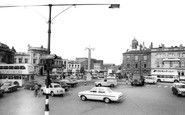
A lady pushes a pram towards the shops, while the man beside the Morris Minor (centre left) calls over the road to his wife. The second shop on the left is Lloyds Bank.

This monumental fountain in the centre of St James Square was built in memory of the Lawson Tancred family, and stands on the site of the former parish church of St James, now moved to Church Lane.

Here is a view over Colston Avenue to Colston Street, with Colston Hall theatre just hidden behind the General Insurance building (centre right).

In 1988 a tile maze was created from the centre of the west wall to the font, and a new organ was dedicated.

Two vehicles from the United Bus Company pick up passengers, the nearer one (centre right) serving the Great Ayton to Redcar route. Behind it, the tall stone building was the Midland Bank.

Cars parked down the centre of the High Street occupy the site of the historic outdoor town market, which still operates today and makes this area a very busy place on Wednesdays and Saturdays.

In the centre, in line with the Marine Hotel, a hut carries the sign 'Lost Children' - always a possibility at the seaside!

The village was an important centre for weaving, but is now more famous for white water canoeing.

In the early 1870s, the Duke of Cleveland's estate near to the town centre was given over to development.

Newton Aycliffe was projected to have five residential districts surrounding a civic and shopping centre, and industry had been attracted to the area - Bakelite had opened a factory as early as 1946.

On the left is the old Sea View Hotel, which was replaced in the 1970s by the dismal tower of the Transport and General Workers Union Holiday and Conference Centre.

It was converted into flats in the 1930s and more lately has been divided between a Baptist holiday centre and Foxes Hotel.

Two bridges and a ford cross the stream that flows past the Blue Anchor Inn, which stands at the centre of the village.

The lifeboat house in the distance (centre) was built in 1899 to replace an earlier station. It was closed in 1934, but it had a brief reprieve during the Second World War.

Holiday bungalows and chalets line the skyline, and the Cove Café is perched on a shelf halfway down the cliff (centre).

Looking out onto Christchurch Bay, Mudeford remains the centre of the fishing industry in the area.

The beach at Charmouth is a mecca for geologists and fossil hunters, and explanatory walks take place from the heritage centre by the mouth of the Char.

The Ilfracombe Hotel (centre left) was built by the Ilfracombe Hotel and Esplanade Company.

Cheap Street, off Market Place and now pedestrianised, retains its medieval and Tudor character: it has a stream running down its centre in a channel.

This rural scene, about a mile east of the city centre along Monks Road, is now much changed.

Closer to the city centre, Broadgate is nowadays a frantically busy dual carriageway, and the site on the left a bus station.

Woolworths and the 1907 Perpendicular Gothic-style Mac Fisheries (a chain long departed from our high streets) were recently demolished to make way for the High Street facade to the Waterside shopping centre
Places (57)
Photos (98)
Memories (1253)
Books (2)
Maps (316)

