Places
36 places found.
Those places high-lighted have photos. All locations may have maps, books and memories.
- Pentre-cwrt, Dyfed
- Pentre Halkyn, Clwyd
- Pentre, Mid Glamorgan
- Ton Pentre, Mid Glamorgan
- Pentre, Powys (near Llangynog)
- Pentre, Powys (near Guilsfield)
- Pentre, Powys (near Bishop's Castle)
- Pentre, Dyfed (near Pontyates)
- Pentre, Powys (near Newtown)
- Pentre, Clwyd (near Mold)
- Pentre, Clwyd (near Ruabon)
- Pentre, Shropshire (near Chirk)
- Pentre, Clwyd (near Hawarden)
- Pentre, Clwyd (near Chirk)
- Pentre, Clwyd (near Ruthin)
- Pentre, Clwyd (near Mold)
- Pentre, Shropshire (near Oswestry)
- Pentre, Powys (near Welshpool)
- Pentre, Clwyd (near Mold)
- Pentre, Shropshire (near Forton)
- Pentre Broughton, Clwyd
- Pentre Gwynfryn, Gwynedd
- Pentre Maelor, Clwyd
- Pentre-clawdd, Shropshire
- Pentre Galar, Dyfed
- Pentre Llifior, Powys
- Pentre-cefn, Shropshire
- Pentre-Gwenlais, Dyfed
- Pentre-Poeth, Dyfed
- Burntwood Pentre, Clwyd
- Pentre Berw, Gwynedd
- Pentre Hodre, Shropshire
- Pentre Llanrhaeadr, Clwyd
- Pentre-celyn, Clwyd
- Pentre Cilgwyn, Clwyd
- Pentre Morgan, Dyfed
Photos
98 photos found. Showing results 2,261 to 98.
Maps
316 maps found.
Books
2 books found. Showing results 2,713 to 2.
Memories
1,253 memories found. Showing results 1,131 to 1,140.
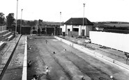
Rock Park Swimming Pool
I attended the North Devon Technical School in the late 50's having passed the 13+ from Barnstaple Secondary Modern ( I've yet to meet anyone that took the 13+ in recent years) I must have been about 14 -15 when the ...Read more
A memory of Barnstaple in 1958 by
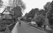
Jasmine Cottage, Petworth Road
In 1956, my family moved into Jasmine Cottage which stands behind the wall on the left of this picture. It was (is) the centre cottage of 3 in one old building. There was a family that lived in the house on the right, ...Read more
A memory of Witley in 1954 by
Platts Farm
I remember Platts Farm. My gran lived in a bungalow (a wooden hut really) right at the far end of the field. There was a small pond and a little stream running through it. We went there every shcool holidays and I stayed there all ...Read more
A memory of Pickmere in 1960 by
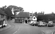
Ightham 1960s
Interesting to see this picture though I don't think that by the 1960s Ightham was ever this free of traffic except early in the morning. The building in the centre of the picture was a petrol station and provider of all sorts of ...Read more
A memory of Ightham by
South East Englands Best Airport Site!
As a small boy in the 1950s I would be taken to see the aircraft at Blackbushe, then London's second airport. Blackbushe was London Heathrow's main fog diversion as it always has been one of the most ...Read more
A memory of Blackbushe Airport by
New Haw Childhood
I have lived in New Haw most of my life. My family moved from Kings Road to Farleigh Road in 1949. One of my first memories was being taken to the New Haw Clinic for day care as my mother worked in London. There I encountered ...Read more
A memory of New Haw by
Woolworths
I also remember Welling corner and those trolley buses. I lived in Welling from 1956 to 1965 and used to travel on the buses to Bexleyheath clocktower to go to Bexley Tech for girls in Townley Road. I also knew Woolworths quite well as I ...Read more
A memory of Welling in 1860 by
Boyhood Memories
I lived here, Woodside Crescent, from 1958 when I was 2 yrs old to 1967 when our family wanted to see more of the world...so we moved to Horley...oh yes, we got around! Went to school near the village centre and further down ...Read more
A memory of Smallfield in 1960 by
A 1950s Childhood Memory
I have very fond memories of Great Haywood during the 50s as my sister and I went to stay with our grandmother during the school holidays. We lived near to the centre of Manchester and so to visit this village in the ...Read more
A memory of Great Haywood in 1956 by
Royal Oak Hotel / George Hotel
In 1964 I was (as Jim Wright) fortunate enough to move to Keswick to work as the assistant manager at the then Royal Oak Hotel, just past the Moot Hall on the far left corner in this photograph. The Royal Oak and George ...Read more
A memory of Keswick in 1964 by
Captions
3,593 captions found. Showing results 2,713 to 2,736.

Beyond is the clocktower at the centre of the town. In the distance is Coombe Hill; since 1904, three years after this view, it has been dominated by a Boer War memorial obelisk.

Preston was the centre of a wheel of railway transport: spokes went off to Blackpool, Lancaster, Blackburn, Manchester, London, Liverpool and Southport.

About 1918 an extension (centre) was made to join the former St Margaret's College (left background). Since closure in 1976 much of it has gone but part survives as Neale House.

Beyond the gates, the Ewell Road extends onwards to the centre of Cheam village.

The large chimney on the guardroom (centre) is of a style attributed to the Flemings, who arrived with the Normans.

In the middle of the 20th century it became an adjunct of the Tidal Institute at Liverpool University, and it is now known as the Centre for Coastal and Marine Sciences - Proudman Oceanographic Laboratory

Its more salubrious site was, and remains, the one pictured here on Milford Hill, just east of the city centre beyond the ring road.

Flimwell is centred on a crossroads near the Kent border. Its church, St Augustine's, was built in 1873.

Being on the far side of the Lancaster Canal from the centre, the school was considered to be out in the country, and the air was good for the boys.

Kingston is well renowned as a shopping centre of excellence, with Bentalls department store in Clarence Street at its hub.

The Barbican, the security tunnel through the centre arch, was added in the 13th century; it is the only remaining barbican in England.

Almost equidistant from Gloucester and Bristol, situated on the southern side of the Severn Estuary, Berkeley is a small market town, a trading centre for the surrounding rural community, as it has

St Michael's tower (right), which dates from the mid 15th century, is all that remains of the city centre church today. The rest was demolished in 1955.

Wheat-straw covered chalk clunch walls at Haydon Farm, and a long 1704-dated barn in Flemish-bond brickwork, stood beside a hayrick in the centre of the village.

The only thing that can be said about the horrendous building in the centre is that it served a useful purpose - a toilet block.

The 17th-century Church Farm (centre), with its brick end wall and gables, was thatched at the time of the photograph.

The centre of the town, shown here, is certainly becoming the domain of the motorist; we can see few vehicles, but a plethora of road signs.

In the picture is the Italianate Town Hall designed by Brightwen Binyon; it was demolished in 1971 after being replaced by a new civic centre at West Park.

An ancient market town, Ormskirk was an important centre for the linen trade during the 16th century, whilst in the late 18th and early 19th centuries there were silk mills in the area.

Known at the time of Domesday as Ferlingeham, it was once a significant market centre, and in later centuries had important paper mills.

The other exit - left of centre - is Lichdon Street. Note that electric street lighting is already in place, only a few months after the Barnstaple Corporation Electricity Works was opened.

Best Outfitters are in the three-storey building, beyond which the Lily Hotel projects towards the road, with Colmer's Hill being the distinctive hilltop (centre).

Leaving the town centre we move along Church Street to the Missenden Road, just past the junction with Pednor Road and Wey Lane.

This is the centre of this secluded little hamlet tucked away on the north side of Hurt Wood, with its modest stone war memorial isolated on a triangular green, opposite the village shop and post office
Places (57)
Photos (98)
Memories (1253)
Books (2)
Maps (316)

