Places
26 places found.
Those places high-lighted have photos. All locations may have maps, books and memories.
- Cemmaes Road, Powys
- Six Road Ends, County Down
- Road Weedon, Northamptonshire
- Severn Road Bridge, Gloucestershire
- Roade, Northamptonshire
- Berkeley Road, Gloucestershire
- Harling Road, Norfolk
- Road Green, Devon
- Builth Road, Powys
- Cross Roads, Yorkshire
- Steele Road, Borders
- Cross Roads, Devon
- Four Roads, Dyfed
- Road Green, Norfolk
- Biggar Road, Strathclyde
- Clarbeston Road, Dyfed
- Five Roads, Dyfed
- Eccles Road, Norfolk
- Grampound Road, Cornwall
- Morchard Road, Devon
- Wood Road, Greater Manchester
- Four Roads, Isle of Man
- St Columb Road, Cornwall
- Clipiau, Gwynedd (near Cemmaes Road)
- New Road Side, Yorkshire (near Silsden)
- New Road Side, Yorkshire (near Cleckheaton)
Photos
14,329 photos found. Showing results 2,961 to 2,980.


Maps
476 maps found.
Books
5 books found. Showing results 3,553 to 5.
Memories
11,058 memories found. Showing results 1,481 to 1,490.
Schools
I was five and walked down this road to the infants school on the left (you can just see the school railings). My future primary school (St Johns) is in the old building to the right. There was a little sweet shop on the left (out of shot ...Read more
A memory of Essington in 1965 by
My Apprentice Days With Northmet Electricity (Eeb)
I was born in Elmgrove Crescent Harrow in 1933 and lived in Pinner Road North Harrow, moving to Wealdstone in 1934. I started at Bridge Scool in 1938 and followed on to Belmont Sec. Modern School ...Read more
A memory of Kenton in 1948 by
1945 To 1966
My grandparents, Jabez Smith and Kate his wife owned the post office in Coombe Valley Road, formerly Union Road, before and during the war. Their daughter Rose Moss (my Mother) ran it from the age of sixteen. They also owned and lived in ...Read more
A memory of Dover by
Evacuation To Combpyne
My sister Margaret and I (nee Rayner) were evacuated to the home and caring of a friend Olive Tuck who had a cottage next to a farm just out of Combpyne. Across the fields where we were allowed to play, was the path to ...Read more
A memory of Rousdon in 1942 by
Princess Christian College
26 Willbraham Road used to be the home of the Princess Christian College of Nursery Nursing where I spent a happy if hectic 18 months - in those days my surname was Smith. We used to be able to go out through the back ...Read more
A memory of Manchester in 1968 by
Combe Florey Primary School
The village school in Combe Florey closed in about 1958 I believe, it exists as a private house now, but I can still remember the mile long walk to and from it, through the lanes every morning and afternoon. Mum ...Read more
A memory of Combe Florey in 1958 by
I Lived Here
I lived at The Malt House, Claverdon in the early mid 1960s. It was owned at the time by Mr Jefferson who lived in a lovely new bungalow a little further away. I loved this house even if it was a bit unusual to live in. I went to ...Read more
A memory of Claverdon in 1964 by
Greenock Mill Street
I remember staying up Mill Street when I was a young girl, we then moved to Tasker Street up Bow Road.
A memory of Greenock in 1956 by
Stanley Road, South Harrow
I lived with my foster family in Stanley Road South Harrow, during the war. Our house backed on to the gas works and I always wanted to climb the gasometer which I did eventually with a friend from across the road. At ...Read more
A memory of South Harrow in 1940 by
Our Home For 30+ Years
Mam and Dad, Lizzie and Edwin Ridley, moved into Slaghill (the cottage on the right of the picture) in 1948 when I was 3 years old. Dad died there in December 1978 and Mam moved up to Chapel Cottages soon afterwards. There ...Read more
A memory of Allenheads in 1948 by
Your search returned a large number of results. Please try to refine your search further.
Captions
5,036 captions found. Showing results 3,553 to 3,576.

Wilfrid Frost lived at Glyn in Park Road.

Across the road to the left stands Low Hall. This building is thought to be a late 13th- to early 14th-century hall that was raised to a pele-tower during the 15th century.

A century on, the view of Church Hill in Marlborough Street is still easily recognisable, despite the two great complexes built on each side of the road, the Lloyds TSB Training Centre on the left and

The scene is similar today, but the road is metalled and very busy with motor traffic. The shop has since been converted to a private house.

In 1836 it became the premises of the wine merchant William Cunnington, and extensive cellars run under the road and the buildings on the opposite side of the street.

There are ornamental flower beds amid grass between the walks and The Embankment road, which curves away from the river to accommodate the park before coming closer to the river near the

This long view of Wendover is taken from the opposite direction to No 44773, looking north-east from the foot of Bacombe Hill; here the national long distance footpath, the Ridgeway Path, leaves the road

The Tringford Road bridge and the mill warehouse to the far right survive, but the canalside store with its bag hoist has been replaced by Heygate Flour, who now move everything by lorry.

Here we see the Grammar School from another angle, looking from East Road back into the city.

Bargate was originally built to guard the main road into Southampton.

It would be difficult to say now, without consulting early maps, exactly where 18th-century Whetstone began and finished on the Great North Road.

This compact village is situated on the main coast road north of Aberystwyth; it grew up to serve the workers of the nearby lead mines and woollen mills.

It is culverted under the main road, and collects in a large lake, which lies between Broadwaters Lane and the estate of houses.

The old tracks from the neighbouring village of Uplyme are the original routes into the town before the construction of the present road along the coast.

Local dry stone walling, brick and Swithland slate are all here in abundance, as the road drops down from Maplewell Hall to the village centre.

west of the town centre, the stepping stones have long provided a foot crossing of the River Rothay, at least for those with good balance; they link Ambleside with properties on the Under Loughrigg road

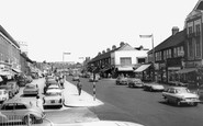
The New Inn, sporting its new Watney's Red Barrel sign by the door and the sign board with the house style lettering, stands up the hill in Road Weedon on the old London to Holyhead turnpike.

The church was sited on the main road, convenient for reforming Broken Cross, then an area of evil reputation. It is quite simple in design, stone with lancet windows.

In the background is the Broadway cinema at the junction of Gernon Road and Eastcheap.

Robert Gernon held the manor, and his name is remembered in Gernon Road, home of the District Council Offices.

Further along the road is the Wesleyan Sunday School (1844) and the Methodist church of 1842. On the left is the old Fox and Hounds Inn, next to the medieval Catheral

All the way north from Burnham to Brean Down, the six miles of road behind the sand dunes and beaches has a string of bungalows, chalets, shops, caravan parks, amusement parks and holiday camps, as well

Mobile homes between River Way and Bridge Road, on the west bank of the River Char, have also been targeted by nature, notably in a flash flood in the 1970s.

The village was an important staging post in the heyday of horse- drawn coaches, and it is not surprising that the road across the wild heath was once the haunt of highwaymen.
Places (26)
Photos (14329)
Memories (11058)
Books (5)
Maps (476)

