Places
26 places found.
Those places high-lighted have photos. All locations may have maps, books and memories.
- Cemmaes Road, Powys
- Six Road Ends, County Down
- Road Weedon, Northamptonshire
- Severn Road Bridge, Gloucestershire
- Roade, Northamptonshire
- Berkeley Road, Gloucestershire
- Harling Road, Norfolk
- Road Green, Devon
- Builth Road, Powys
- Cross Roads, Yorkshire
- Steele Road, Borders
- Cross Roads, Devon
- Four Roads, Dyfed
- Road Green, Norfolk
- Biggar Road, Strathclyde
- Clarbeston Road, Dyfed
- Five Roads, Dyfed
- Eccles Road, Norfolk
- Grampound Road, Cornwall
- Morchard Road, Devon
- Wood Road, Greater Manchester
- Four Roads, Isle of Man
- St Columb Road, Cornwall
- Clipiau, Gwynedd (near Cemmaes Road)
- New Road Side, Yorkshire (near Silsden)
- New Road Side, Yorkshire (near Cleckheaton)
Photos
14,329 photos found. Showing results 3,341 to 3,360.


Maps
476 maps found.
Books
5 books found. Showing results 4,009 to 5.
Memories
11,058 memories found. Showing results 1,671 to 1,680.
Home
I was born in Mid Calder; my sister in Pumpherston; and my brother in Uphall Station. We lived at 17 Nettlehill Road until we emigrated to Canada in October 1957. We all went to the school in Uphall Station and my favourite teacher ...Read more
A memory of Uphall Station in 1957 by
Growing Up In Runcorn
I was born and bred in Runcorn. I lived on Weston Road. I was born in 1963 and left the town in 1984. What a great place it was. You could buy just about anything in Runcorn from food, furnishing, a new car, you name it and a ...Read more
A memory of Runcorn

Bowes Rd
I lived in Bowes Road from 1980 until 1985, when circumstances meant I had to move away, but I always have good memories of the area, as some of my best times were spent there. I had reason to return recently and I could not take in ...Read more
A memory of Palmers Green by
The Bus To Bredurst
The Bredhurst bus did indeed pass the Jezreels but it was a number 38 (not 8). I was at Gillingham Grammar School from 1948 to 1955 and used regularly to catch that bus to my home in Forge Lane, Bredhust. I have vivid ...Read more
A memory of Gillingham in 1948 by
The Irish Bacon Shop
Stuck in the middle of this parade of shops is the cream coloured frontage Irish Bacon Shop & my mother worked there.We lived at 41a Willesden High Road, just a short hop to the shop, and I have found memories of the ...Read more
A memory of Willesden in 1966 by
Life In Bury For A Little Boy.
Millie Grinsted nee Cheeseman was my great aunt. She was the sister of my paternal grandfather William Edward Cheeseman. I remember staying with her and Edward at times during and after the war. I remember on ...Read more
A memory of Bury in 1940 by
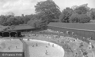
Open Air Swimming Pool Colchester
Many a happy day was spent at the open air swimming pool in the late 1950s - early 1960s. The changing rooms, under the road bridge, were not nice and always covered in water. I had swimming lessons with Mr ...Read more
A memory of Colchester in 1957
Happy Days
I lived in Cobden Road behind the fire station and went to school first at Mayville Road and my first teacher's name was Mrs Frith? Then I was transfered to Davies Lane because I lived on the wrong side of the high street. Finally ...Read more
A memory of Leytonstone by
The Blake
The following information relates to the opening of the Blake school in Hednesford. The Blake school was built to replace the Central Secondary school for boys which was in Burns Street Chadsmoor (where Chadsmoor junior school is ...Read more
A memory of Chadsmoor in 1961 by
During The Second World War
This story is a memory during the Second World War. My father Samuel Fredrick Richardson was the air-raid warden. There was a brick shelter, built on the village green. Most of the village used to use it. One ...Read more
A memory of Frimley Green in 1940 by
Your search returned a large number of results. Please try to refine your search further.
Captions
5,036 captions found. Showing results 4,009 to 4,032.

This view is looking westwards towards Symondsbury and Exeter along what was generally called the London Road, with a variety of hand-carts and a couple of girls failing to stay still for Frith`s

It was replaced by a housing estate, Belmont Heights, with access across the railway line from the Brighton Road, north of Belmont Station.

Ironically, when finally built in the 1980s the relief road, St Mary's Way, demolished the south part of market-place, and the town hall need not have been demolished.

Angell Town was an estate of 1850s Italianate villas, mostly semi-detached, built on curving roads centred on St John's church, whose 1853 tower is crowned by four pinnacles.

The mansion at the east end near the North Circular Road survived, although there were uncertain years in the 1970s.

in front of the camera would be taking her life in her hands were she to attempt such a casual progress today, when modern traffic thunders up this hill on its way to Cobham along the old Portsmouth Road

In 1967 the statue was moved to allow a road widening that did not materialise, and in this photograph it points to the building opposite, Gwyn's birthplace, which was demolished in the 1960s to make way

The houses beyond stood in the Dartford Road. The ground was given to the town in perpetuity in the late 18th century by the 3rd Duke of Dorset.

At the time this photograph was taken, the bend in the road was a notorious accident black spot: here heavily laden lorries often came to grief on the long descent down Blakeney Hill into the village
Many of the houses along the High Road at Turnford were built to accommodate the workers on the nearby market gardens. On the centre left, in the far distance, is a garage.

The 14th-century bridge was a three-road crossing point all those years ago. Now it is a unique part of Lincolnshire's history.

A boy is sitting between the shafts of a handcart in the middle of the road. But no one would dare leave a hand cart in the middle of the street today, as these children have!

The International Stores, housed in a Georgian building on the left, was in a prime position on the corner of Meadow Road.

Skegness and Porthcawl, held speed events for sports cars along the sands or the promenade, and it was possible to tax and equip high-powered cars such as the 2-litre Grand Prix Sunbeam for use on the roads

Now on the B3254 to Bude, St Stephens Hill was one of the roads administered by the Turnpike Trust, who set the tolls.

The Toll House at St Stephens was built in 1761 by the Launceston Turnpike Trust, which had come into being the previous year with the intention of 'widening and keeping in repair several roads leading
Now on the B3254 to Bude, St Stephens Hill was one of the roads administered by the Turnpike Trust, who set the tolls.

The Brown Cow public house is on the right, and the Black Bull Hotel can just be made out further down the road. The village is 400ft above sea level.

Because Roundhay was on the outskirts of Leeds, transport to the Park was difficult; those who did venture along the old turnpike road found a beautiful site - but it lacked basic facilities.

East of the church and the Moot Hall, a jettied timber-framed building of about 1500, standing in its green, is the main north-south village road, the High Street.

Dale Street was one of the ancient streets of the city and the main road to all points south.

The road crosses a brook in the middle distance, a tributary of the young River Cherwell.

The Crown Inn and Restaurant (the white building to the left of the road) is still there, as are the other houses. This photograph looks towards Market Rasen.

It stands at the junction of five roads. Mr Sim's will also provided for the annual sum of £5 to be paid to a firm of local jewellers for the winding of the clock.
Places (26)
Photos (14329)
Memories (11058)
Books (5)
Maps (476)

