Places
19 places found.
Those places high-lighted have photos. All locations may have maps, books and memories.
- Hill of Mountblairy, Grampian
- Hill of Banchory, Grampian
- Hill of Fearn, Highlands
- Rocky Hill, Isles of Scilly
- Hill of Beath, Fife (near Dunfermline)
- Hill of Drip, Central Scotland
- Hunny Hill, Isle of Wight
- Quarr Hill, Isle of Wight
- Quine's Hill, Isle of Man
- Kite Hill, Isle of Wight
- Broom Hill, Avon
- Merry Hill, West Midlands
- Rose Hill, Derbyshire
- Cinder Hill, West Midlands
- Barton Hill, Avon
- Spring Hill, West Midlands
- Golden Hill, Avon
- West Hill, Yorkshire
- Oak Hill, Staffordshire
Photos
2 photos found. Showing results 661 to 2.
Maps
4,410 maps found.


Books
3 books found. Showing results 793 to 3.
Memories
3,579 memories found. Showing results 331 to 340.
Upbringing
I went to school first at Tondu infants and then to the Primary school, I remember when we had the school photographs taken in the play yard (where are they now?). I had a really great and happy childhood there living with all the ...Read more
A memory of Aberkenfig by
Evacuee
I was evacuated from London to Oxford with Burlington School on 1st September 1939. At first we had our lessons in the old Milham Ford School premises but after a few weeks transferred to the new school in Marston where we shared the ...Read more
A memory of Oxford in 1940 by
Thanks For The Memories
My goodness this brings back memories! I grew up in Irby and we lived in Oaklea Road from the late 40’s to the late 60’s – I’m now a true blue Aussie having lived in Queensland since the mid 70’s but about to revisit Irby in ...Read more
A memory of Irby by
Wednesbury As A Lad
I have too many memories to many to go into - apprentice Elec; at Patent Shaft steelworks, left Wednesbury aged 20 for 2 years RAF National Service, lived in south Yorkshire since 1954 - think about standing with fire ...Read more
A memory of Wednesbury by
A Wartime Child
I was born in 1935 at 25 Cambridge Road, maiden name Lee. There were six of us, parents, 2 older sisters, Beryl and Gwen, and grandmother. I remember many of the shops from the late 30's to the early 50's when we moved to ...Read more
A memory of North Harrow in 1930 by
Notes From The Frith Files.
This photograph shows residents waiting for the No.144 Midland Red bus from Malvern to Worcester outside the village shops. Far left is EW Bird's butchers, left is Cromptons newsagents, off picture further left is Procters ...Read more
A memory of Powick
Maes Y Llan Where I First Lived
These houses are in Maes-y-llan.My father Den and mother Hilda Wildblood with my sister Anne were the first to live in Number 6 when the houses were built in 1948 I believe.I was born in 1954 and it was my first home ...Read more
A memory of Meifod in 1955 by
Coopers And Booths
My Great, Great Great Grandfather, William Booth, used to push a cart up and down the streets of Clayton le Moors with his son John Booth, selling shellfish. He was known as 'Muscle Bill' and his son, 'Oyster Jack'. (This ...Read more
A memory of Clayton-Le-Moors in 1890 by
Wonderful Times Spent With My Grandparents
My mother and her family are from Stiffkey. I was christened in the Stiffkey church in September of 1965. My grandparents lived at Camping Hill and I was always visiting them. I have lovely memories of ...Read more
A memory of Stiffkey in 1965 by
My Early Years In Salford
I was born in Salford, at 15 School Street in 1951. My first school was Stowells Memorial, I think the headmistress was a Miss Dent. There was a butchers shop one the corner with the same name as our family, but I don't ...Read more
A memory of Salford in 1951 by
Captions
1,749 captions found. Showing results 793 to 816.

Taken from the edge of Parsonage Woods to the north of the town, this view, almost unchanged today, looks past the cornfield towards the historic market town nestling in its Chiltern valley.

The M20 now cuts directly across this picture, and new factory and housing developments fill the scene.

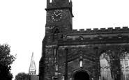
This Roman Catholic church dedicated to St Mary stands on Stow Hill on the site of an earlier, smaller, edifice.

Here we have a closer view of the house on the crossroads before going down Mill Hill. It has a varied brick pattern for the walls, mullion windows and a tiled roof.

Crays Hill is a thoroughfare settlement in the parish of Ramsden Crays—the name ultimately coming from the 12th-century de Crei family.

Beyond the village rises Wetherlam, the most northerly of the Coniston Fells, and over to the left, hidden by cloud, Lancashire's highest peak, the Old Man.

The red sandstone parish church of St Mary was built by Roger Growdon and dedicated in 1450 by Bishop Lacey, whose name can still be seen on pub signs around Devon.

The flatness of the Wolds is interrupted by the hill on which the tiny hamlet of Brigham sits.

Turning left out of Castle Hill, Bailgate follows the course of the Roman Ermine Street towards the old Roman north gate from the city, the Newport Arch.

The Cotswolds reach their highest point at West Down, 1083 feet above sea level, above this parish of Cleeve Hill, east of Cheltenham.

Known today for its caravan parks and the long sandy beach of Black Rock sands, Morfa Bychan, just west of Porthmadog, was long celebrated for the story of Dafydd Garreg-Wen, the blind harpist, known for

Until mid-Victorian times, this part of the road, known now as Greenhill, had been called New Well Hill. Here, we are looking towards the Green at the turn of the century.

The flatness of the Wolds is interrupted by the hill on which the tiny hamlet of Brigham sits.

This interesting picture shows the bridge over the Rother at the bottom of Adhurst Hill. The post office on the right superseded the toll house on the turnpike (1711).

This view of the castle grounds looks east from the church tower. Friesian cows are grazing; perhaps they belong to Mr E Ball, who owned property to the right in the Market Place.

Taken from Overton Hill, this view shows the town with the Mersey estuary in the distance beyond the sand dunes. It is from here that the Sandstone Trail now begins.

Perched on a windy hill a mile or two north of Portscatho, Gerrans has been called a 'plain-looking village'.

The church of St Lawrence is superbly positioned on the brow of a narrow spur offering splendid views to the north of the Greensand Hills.

This attractive village retains its quiet rural atmosphere; it is ranged along its north-south street about a mile to the south of Kibworth Beauchamp.

So called because a moneyer is reputed to have stayed here for a time in the 14th century, this is really part of a medieval merchant's house.

Herrington's window (right) is a treasure-trove of 1960s grocery products: Lyons Swiss Rolls, Brooke Bond Tea, Woodbines, and Bev. It later became the NatWest Bank.
Now in the care of the National Trust, Ditchling Beacon was one of a chain of fires lit to warn of the Spanish Armada in 1588. Much earlier than that it was a hill fort.

A herd of Shorthorn cattle is driven down the main street of West Witton, which stands at the eastern entrance to Wensleydale.

The recent history of the ancient village of East Keswick is inextricably linked with the fortunes of the nearby 'big house' of Harewood.
Places (19)
Photos (2)
Memories (3579)
Books (3)
Maps (4410)

