Places
17 places found.
Those places high-lighted have photos. All locations may have maps, books and memories.
- Bridge End, Oxfordshire
- Bridge End, Lincolnshire
- Bridge End, Essex
- Bridge End, Bedfordshire
- Bridge End, Clwyd
- Bridge End, Warwickshire
- Bridge End, Surrey
- Bridge End, Durham (near Frosterley)
- Bridge End, Northumberland (near Hexham)
- Bridge End, Hereford & Worcester (near Tirley)
- Bridge End, Hereford & Worcester (near Bosbury)
- Bridge End, Shetland Islands
- Bridge End, Cumbria (near Carlisle)
- Bridge End, Northumberland (near Hexham)
- Bridge End, Devon (near Kingsbridge)
- Bridge End, Devon (near Sidmouth)
- West End, Yorkshire (near Pateley Bridge)
Photos
40 photos found. Showing results 881 to 40.
Maps
520 maps found.
Books
2 books found. Showing results 1,057 to 2.
Memories
1,928 memories found. Showing results 441 to 450.
1st Hazel Slade Scouts
I was born at the bottom of the Rawnsley Road, by the double bridges, known as Pool End, after Hednesford Park which used to be a pool. I was a Cub in the 1st Hazel Slade Scouts, our meeting place was at the church ...Read more
A memory of Hazelslade in 1950 by
My Links To Cheslyn Hay
I was born in 'The Lot' on Cheslyn Hay in 1950. I have been able to trace my lineage back to the 1700's through the Brough, Horton and Cadman families. The Horton family lived in all or some of the cottages in Dundalk ...Read more
A memory of Cheslyn Hay by
Pantddu Farm And Aberbeeg
I grew up in the farm in the picture. My parents were Ern and Megan Sheppard. Dad delivered milk for many years, initially from churns carried around in a horse and cart and later the milk was in glass bottles from a ...Read more
A memory of Aberbeeg in 1940 by
St Michaels Church,Pitsea
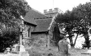
Born in Pitsea in 1938, I was christened there and visited the church during holidays from boarding school. The picture shown is a view of the back (south side) of the church. My maternal grandfather, father and one of my ...Read more
A memory of Pitsea in 1940 by
1950s Waterfoot
My grandmother used to take me to Waterfoot every day from Warth bridge to get a daily comic. I can still recall the titles, Lion, Beano, Topper, Knockout, Eagle etc. I used to make a beeline for the toy shop at the top of the ...Read more
A memory of Waterfoot by
Percy Smith
My mum was born at the end of this row, near the Bollin, to Percy & Gertrude SMITH, in 1934. In 1978, Percy was recorded while he walked around the village sharing his encyclopedic knowledge. I will be dropping off CDs of this ...Read more
A memory of Prestbury in 1930 by
Growing Up Childhood Memories
I was born in Elm Park Avenue in 1937 and have memories of the Second World War and after. I can remember during the war, especially during the Blitz, bedding down with my mother under the stairs in a steel wire ...Read more
A memory of Elm Park in 1940 by
Staines Family Of Sutton Bridge
My family moved from Sutton Bridge to Canada in or around 1912 or 1913. Looking for any family that may still be in that area. William Staines and his wife Rosa, and their 6 or 7 children left for Canada. Thanks, Lisa Freeman, in Canada
A memory of Sutton Bridge in 1900 by
The Rose And Crown
Ivy Myers. I wonder how many people from Chalfont remember the "Rose and Crown", a Benskins pub. My father owned it from 1946 until 1950. There was also the “Kings Head” which was on the corner of Joiners Lane. Of ...Read more
A memory of Chalfont St Peter in 1949 by
The Good Old Days
Hi, as a kid me and our Mick would be look outs for workers from Camel Lairds playing pigeon toss for pennies. At the side of the building to the right of the tunnel we lived in the Abbey Buildings and the tunnel area was a ...Read more
A memory of Birkenhead in 1958 by
Captions
1,770 captions found. Showing results 1,057 to 1,080.

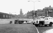
Fred Atter's grocery shop and café and the old post office went to make way for the footings of the A1 flyover, which now dominates this scene.

An interesting view from the south bank of the Thames looking east, before Christchurch Meadows on the left were made into a riverside park, and, more significantly, before Reading Bridge was built

The 15th-century tower of All Saints, the Anchor pub and the elevation of the bridge, which is medieval in origin with 19th-century additions, add up to a classic photograph of the entrance to the village

Across the river bridge is the White Swan, recorded as an inn in the early 17th century.

Looking across Bristol Bridge towards High Street. Dominating this picture is the church of St Nicholas. Bishop Secker's Diocese Book has an interesting comment on the church wardens.

The bridge was authorised by Act of Parliament in 1885 and opened in 1894.

This remarkable and historic view from high on the Houses of Parliament shows Queen Victoria's open landau leading the procession across Westminster Bridge.

The floating bridge crossed the Medina from West to East Cowes. Notice the wharves and docks in the background.

The Aylesbury arm of the Grand Union departs from the main line at Marsworth, and has some 16 locks in 6 miles, very narrow and not for the faint-hearted.

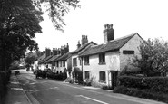
The old stone bridge straddles the river Kennet, fringed by meadows and trees. The village is in a Conservation area, with plenty of brick-built thatched houses in its centre.

Thatch and timber buildings such as the one in this photograph are not an uncommon sight in Ibsley. There is a small brick church here, as well as a stone bridge over the river to Harbridge.

We are near the long stone road bridge to Houghton, built in 1875 and crossing the tidal River Arun. Vinson's was a popular riverside tea rooms and garden. There is still a tea garden on the site.

The tower, marking the eastern entrance to the High Street, dates back to 1492 and took seventeen years to complete. The delay was probably caused by lengthy financial problems.

Welford Reservoir was constructed in 1837 to store and supply water to the Welford Arm which then fed the Leicester Arm of the Grand Union Canal.

In the distance beyond the bridge is a pub. At the time of this view, it would have been called the Rose and Castle.

Cross the humped bridge over the river from Coltishall, and the village becomes Horstead.

The Foregate and Foregate Street continue the line of High Street northwards and developed as a suburb many centuries ago.

Before reaching Chilbolton village, here is the Seven Stars public house and the beautiful River Test, viewed from the bridge. Across the water was once the railway.

The nets strewn across the railings of the bridge emphasise the importance of this small harbour; in 1887, it boasted over 80 cobles and yawls, employing over 200 fishermen.

This downstream view, taken from almost the same vantage point as N50079, shows the ugly and large hotel built in the intervening fifteen years close to both Trent Bridge cricket ground and Nottingham

This is the view from Poole Bridge. The Nissen hut on the left has today given way to a building occupied by the Lifeboat Station and Dorset Police Marine Section.

was a large mill on the River Nadder just upstream from the confluence with the Avon.The Millers House seen here is all that remains of a much larger building; it is now almost invisible from the bridge

Bentalls department store is in a commanding position, and towers over the other shops in Clarence Street.

The village was once famous for its lead mines, and the remains of many of them still survive in the gills of the surrounding fells.
Places (17)
Photos (40)
Memories (1928)
Books (2)
Maps (520)

