Places
2 places found.
Those places high-lighted have photos. All locations may have maps, books and memories.
Photos
80 photos found. Showing results 121 to 80.
Maps
10 maps found.
Books
Sorry, no books were found that related to your search.
Memories
563 memories found. Showing results 61 to 70.
Growing Up In Fordingbridge
I grew up in Fordingbridge between 1949 when I was born and 1967 when I left for University. I have so many memories that I couldn't possibly put them all down here, so I am just selecting a few good or striking ...Read more
A memory of Fordingbridge in 1960
Pontypool
My family lived in The Globe in Crane Street from 1973 until I guess 1980, although I had left in 1979, John and Kitty, ran a fab pub which was always very busy with many customers working in the council and police station. The pub was ...Read more
A memory of Talywain in 1978 by
Terrified By White Masses
Hi I was taken to the upper Rhondda valley (Tynewydd) by my mother in 1940 , I was some 9 yrs old. I went to school both primary and secondary (Treherbert boys school). I had lots of cousins. Myself and my cousin ...Read more
A memory of Blaengwynfi in 1940 by
A Yokels Tale
A Personal Recollection of growing up during the last days of the pedestrian era in rural England by Tom Thornton A Yokel's Tale My earliest recollection of my Thornton grandparents, Alice and Tom, dates back to my pre-school ...Read more
A memory of Owslebury in 1941 by
My Childhood Days Brynna Boy
8 Southall Street /16 Tan-y-Bryn. We, the Brynna Boys, used to run to school, Mr & Mrs Davies Head Master and thei two daughters, strict and friendly, firm and kind. I can only describe those happy days, Coronation ...Read more
A memory of Brynna in 1953 by
Selsdon Parade Residential Flat
My family and my father's before that (surname Kent) lived in Selsdon (84 and 32 Foxearth Road, 170 Littleheath Road, and 24 Benhurst Gardens) spanning c. 1930 - 1989. But at one point (after my father's death), my ...Read more
A memory of Selsdon in 1982 by
The Pike
Many years ago in the late 1960s there was a stretch of canal down by old Royston. The local fishing club would spend hundreds of pounds on replenishing the fishing stocks with rainbow trout - the only problem with this idea was ...Read more
A memory of Royston by
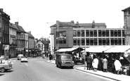
Market Days
I remember the various market stalls well, and the market cafe where you could be a greasy bacon cob, and a well stewed tea from the giant tea pot ! I used to buy a bundle of nylon stockings from a stall on the town hall corner. There ...Read more
A memory of Worksop in 1966 by
Twelve Happy Months
I was born in Nant Gwynant in 1925 and lived there for the first 20 years of my life. In 1944 I was drafted into the army and served in German and Italy. Upon release in 1947, I decided to try and make a career in ...Read more
A memory of Nantgwynant by
The Shop In The Picture.
My father, Peter Mansfield, owned this shop from c1955. He was an electrician and refrigeration engineer. I can remember filling cans with paraffin for my father to deliver. My future husband says he only married me because ...Read more
A memory of Felsted in 1955 by
Captions
201 captions found. Showing results 145 to 168.

Of the shops on the right, the Midland Bank is now, of course, HSBC.
This view from St Mary's tower has Monk Street in the foreground. Centre left is the Bethany Baptist Church, which opened in 1827 when 30 members left the Frogmore Street Church.

Just on the left of the picture is the entrance to Lewis's Department Store, the first large-scale retail outlet in Manchester.

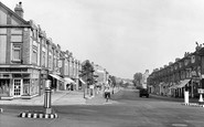
By the 1960s, more and more holiday visitors were arriving by car as well as by rail.

Designed by Henry Edward Kendall in 1839, and situated to the west of Cockfosters Underground station, this stock brick church was financed by the Bevan family who owned Trent Park, and whose origins were
This view from St Mary's tower has Monk Street in the foreground. Centre left is the Bethany Baptist Church, which opened in 1827 when 30 members left the Frogmore Street Church.
The small Norman church at Great Amwell stands close to the New River and contains a memorial to Robert Mylne, one of the engineers to the New River Company.

Recent restoration has beautified St John's, the parish church, which has long played an important role in the Fylde. It was the only church before 1840.

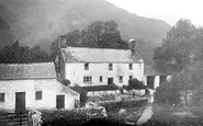
Sykes Farm is typical of the isolated farms in this area. Another was Birkenhead Farm, where James Baines, woollen draper and benefactor to education in the Fylde, was born.

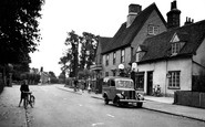
Farther down the A330 is Stud Green, a hamlet of Holyport. Its character is now largely suburban, following much rebuilding. This view looks west.

The Exeter Ship Canal, five miles long, reaches the sea at Topsham, and was built in 1564-6 after the building of a bridge at Countess Wear stopped the use of the river for trade.

This wonderful nostalgic photograph shows steam engine 'black 5', the work-horse of the LMS region, heading south with non-corridor stock on a local, probably to Bamber Bridge and on to Blackburn.

This view is from an upper balcony of Eldon House, one of the eleven-storey blocks of council flats built c1960 on the Loughborough Estate.

From the elevated position of St Andrew's Church we look down the Aire Valley, where now a dual carriageway leads into Keighley.

The war memorial is centrally placed in the village alongside the winding street by the stream. The roots of tradition run deep here, and some old customs were observed until the 19th century.

Eastleigh Library, built in 1936, provided a welcome addition for the people of Eastleigh. It was well stocked with books, and soon became too small for the needs of the population.

In 1885 the Marine & General Company purchased land here, and began building Frinton Haven, which was to have a market, a pier, a tidal basin, and pleasure gardens.

St Teresa's Convent was established in Effinghamhill House, a stucco early 19th- century mansion in the chalk hills two miles south of Effingham village.

Victorians promenade on the newly-opened second Swanage pier.

Battlemented parapets of the 15th-century nave and porch of St Giles Parish Church are seen here on the corner with North Road (left).
The national government also developed local offices.

Then, it was a bustling port with barges moored two or three deep unloading timber and barley. A few more years earlier, there would have been the occasional sailing barge with huge brown sails.

The half-timbered Kings Head inn in the background recalls the coaching age: Northleach was on the main London, Oxford, Gloucester and South Wales road (the main A40 road now by-passes the
The half-timbered Kings Head inn in the background recalls the coaching age: Northleach was on the main London, Oxford, Gloucester and South Wales road (the main A40 road now by-passes the
Places (2)
Photos (80)
Memories (563)
Books (0)
Maps (10)

