Places
36 places found.
Did you mean: street or streetly ?
Those places high-lighted have photos. All locations may have maps, books and memories.
- Heathfield, Sussex (near Cade Street)
- Street, Somerset
- Chester-Le-Street, Durham
- Adwick Le Street, Yorkshire
- Scotch Street, County Armagh
- Friday Street, Surrey
- Potter Street, Essex
- Boughton Street, Kent
- Newgate Street, Hertfordshire
- Streetly, West Midlands
- Shalmsford Street, Kent
- Green Street Green, Greater London
- Boreham Street, Sussex
- Park Street, Hertfordshire
- Cade Street, Sussex
- Appleton-le-Street, Yorkshire
- Hare Street, Hertfordshire (near Buntingford)
- Romney Street, Kent
- Trimley Lower Street, Suffolk
- Streetly End, Cambridgeshire
- Hare Street, Hertfordshire (near Stevenage)
- Brandish Street, Somerset
- Colney Street, Hertfordshire
- Langley Street, Norfolk
- Silver Street, Somerset (near Street)
- Street, Yorkshire (near Glaisdale)
- Street, Lancashire
- Street, Devon
- Street, Cumbria (near Orton)
- Street, Somerset (near Chard)
- Bird Street, Suffolk
- Black Street, Suffolk
- Ash Street, Suffolk
- Broad Street, Wiltshire
- Brome Street, Suffolk
- Penn Street, Buckinghamshire
Photos
21,808 photos found. Showing results 3,981 to 4,000.


Maps
1,622 maps found.
Books
1 books found. Showing results 4,777 to 1.
Memories
6,666 memories found. Showing results 1,991 to 2,000.
The George Ph, Wanstead
Facing the viewer is the George Public House, which I believe still exists; behind is Wanstead underground station and an open area of grassland leading to Redbridge Lane and my then school, Wanstead County High. The High ...Read more
A memory of Wanstead in 1969
My First Glimpse Of Gravesend.
I arrived in Gravesend in 1958 on the back of my boyfriend's motorbike, we had travelled from Colchester in Essex. My father, who was in the army, had been posted to Gravesend so we all had to move. We crossed the ...Read more
A memory of Gravesend in 1958 by
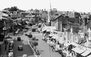
View On West Street
The second shop on the left was Jury Cramp's jewellers, now occupied by H Samuel. Mr Cramp was a well-known figure around Horsham and operated an alcohol-free hotel in Market Square. The giant spectacles just visible in the photo ...Read more
A memory of Horsham by
Vivian Avenue...
Suzanne and I used to play truant from Sunday School... This is the exact spot where we got caught by my mother (What are YOU doing here??!)...There was Goldstein's deli, where we used to buy the most delcious sweet & ...Read more
A memory of Hendon in 1957 by
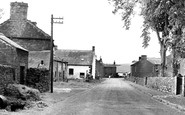
Croglin 1958
When my husband and I married in March 1958, he bought the cottage nearest the camera on the left; no electricity, no bathroom......it cost the princely sum of £300! The building at the end of the street is the pub, and behind the ...Read more
A memory of Croglin by
When I Was A Child
My father was born in Great Bedwyn, his name Arthur Maurice Hatter. When I was young in 1952 we were invited to stay with a member of his family in 47 High Street, I remember they had a wonderful garden, layered with full ...Read more
A memory of Great Bedwyn in 1952 by
Childhood
Having just stumbled across this website and viewed the photographs, I immediately went into nostalgia mode. I was born in Alrewas in 1938 in one of the small cottages in Main Street just down from Mansell's bridge, and then moved to The ...Read more
A memory of Alrewas in 1940 by
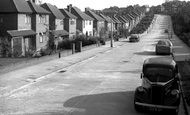
Woodlea Drive
I used to come down and up this road from the bus stop every day to and from school. One of the boys who grew up in this street (a house on the right as I remember) started playing for a very influential rock band called the herd. ...Read more
A memory of Bromley in 1967 by
Wolf And Hollander
There were a few sizeable department stores in Bromley, including Harrison Gibson and Wolf and Hollander (whose flag you can see waving on the left). I am pretty sure it was Wolf and Hollander that suffered an extraordinary fire ...Read more
A memory of Bromley in 1961 by
Teenage Memories
Cove was a special place, a place where I was born, at 11 Sydney Smith Close...now stands Beverly Crec.... My grandad Matthew Smith lived at 39 Holly Rd, and worked on the railway as a plate layer. Growing up we lived in Hazel ...Read more
A memory of Cove in 1958 by
Captions
5,381 captions found. Showing results 4,777 to 4,800.

First to be completed was a pedestrian way linking Castle Street with the bus station. This was called Birdcage Walk, and once included an aviary housing tropical birds.

The High Street runs parallel to the north wall of the Abbey precinct and has a good range of Georgian and early 19th-century two- and three-storey houses.

The resulting Treaty of Wedmore divided England into two: the Danes were ceded all the territory east of Watling Street, the 'Danelaw'.

The first house on the left is named The Old Post Office, and the Old Cobblers Shop is further up the street.

By now Hitchman's the chemists had been swept away: Montague Burton had built an art deco emporium (left) on the corner of Silver Street.

On the exposed Wolds, the ironstone church is situated on the south side of the village street, away from the main A606 Nottingham to Stamford road.

This traffic island at the south end of the High Street, with its random stone walling, double yellow lines, and Festival of Britain-style sign, somehow epitomises a rather unlovely village.

Note the different styles of street lights in this view. There are at least three on the right-hand side, and on the left the remains of gaslights are very much in evidence.

Royal Arcade on the right is the oldest arcade in the city, which links The Hayes and St Mary Street.

This peaceful view of the old High Street looks down the hill to the Harrow Inn at the bottom.

The next house, of the same date, is at right angles to the street with a tall carriage entrance. The late 19th-century shop extension beyond is Towell's fish and chip shop.

We are looking downhill from the east, and the entrance to D H Lawrence's Victoria Street can be seen half-way down on the right by the white building.

We are looking downhill from the east, and the entrance to D H Lawrence's Victoria Street can be seen half-way down on the right by the white building.

The Sir Frederick Milner School was built as a secondary modern school in the south- east of the town, amid a maze of narrow streets.

The coal wharves at the canal basin by Walton Street were soon joined by factories along the canal.
On the exposed Wolds, the ironstone church is situated on the south side of the village street, away from the main A606 Nottingham to Stamford road.

In this photograph the main road looks quiet, but traffic between Leicester and Loughborough would, in a few short years, build to a crescendo through the narrow streets.

This looks Southwards along South Street to St Mary`s parish church (centre).

The present church of 1860, by G E Street, the architect of London's Law Courts, is a simple flint church with brick bands and stone dressings. Its churchyard acquired a Millennium lych gate in 2000.

The photograph gives an unusual perspective in that the exit from the bridge and the High Street beyond appears to be restrictive for both traffic and pedestrians.

Clarence Bridge, later Newport Bridge, takes us through the Old Green Crossing and into the High Street. From here we can just see the dome of the Corn Exchange (centre).

Harrow Park winds away to the east of the High Street, past one or two rather grand houses, to arrive at Deynecourt at the foot of the hill.

Further down the street, we see a wonderfully-posed assortment of turn-of-the-century trades - a delivery boy in his striped apron, someone pushing a cart with a water barrel, and the village postman.
The first house on the left is named The Old Post Office, and the Old Cobblers Shop is further up the street.
Places (385)
Photos (21808)
Memories (6666)
Books (1)
Maps (1622)

