Merry Christmas & Happy New Year!
Christmas Deliveries: If you placed an order on or before midday on Friday 19th December for Christmas delivery it was despatched before the Royal Mail or Parcel Force deadline and therefore should be received in time for Christmas. Orders placed after midday on Friday 19th December will be delivered in the New Year.
Please Note: Our offices and factory are now closed until Monday 5th January when we will be pleased to deal with any queries that have arisen during the holiday period.
During the holiday our Gift Cards may still be ordered for any last minute orders and will be sent automatically by email direct to your recipient - see here: Gift Cards
Places
36 places found.
Those places high-lighted have photos. All locations may have maps, books and memories.
- Cardiff, South Glamorgan
- Barry, South Glamorgan
- Penarth, South Glamorgan
- Rhoose, South Glamorgan
- St Athan, South Glamorgan
- Cowbridge, South Glamorgan
- South Molton, Devon
- Llantwit Major, South Glamorgan
- Chipping Sodbury, Avon
- South Chingford, Greater London
- South Shields, Tyne and Wear
- Ayr, Strathclyde
- St Donat's, South Glamorgan
- Llanblethian, South Glamorgan
- Thornbury, Avon
- Llandough, South Glamorgan
- Fonmon, South Glamorgan
- St Nicholas, South Glamorgan
- Jarrow, Tyne and Wear
- Penmark, South Glamorgan
- Font-y-gary, South Glamorgan
- Maybole, Strathclyde
- Yate, Avon
- Oxford, Oxfordshire
- Torquay, Devon
- Newquay, Cornwall
- Salisbury, Wiltshire
- Bournemouth, Dorset
- St Ives, Cornwall
- Falmouth, Cornwall
- Guildford, Surrey
- Bath, Avon
- Looe, Cornwall
- Reigate, Surrey
- Minehead, Somerset
- Bude, Cornwall
Photos
5,054 photos found. Showing results 821 to 840.


Maps
2,499 maps found.


Books
1 books found. Showing results 985 to 1.
Memories
1,580 memories found. Showing results 411 to 420.
Caroline Street
My grandma was a Bell before she married Harry Davison and eventually went to live in South Market Street. She, her parents and siblings had lived at 32 Caroline Street, until they all married. Lizzie Maddison (my great-aunt ...Read more
A memory of Hetton-Le-Hole in 1950 by
Ww2
When I was about 5 years old I remember my mum picking me up from Smallfield school on her bike, I was in the back on a little seat when a doodlebug roared overhead, and the engine switched off ... My mum panicked, and pushed me off the ...Read more
A memory of Smallfield in 1943 by
Halcyon Days In The 1950s
What fantastic days they were, despite the hardship. We were a family of 9 Seven children Allan Joy,twins Michael and David, myself Sam and a second set of twins Kathryn and Brian I too remember Mrs Greys shop, ...Read more
A memory of Wrottesley Park in 1955 by
Frenchay Hospital, Bristol Built By The American Army
Frenchay Hospital in Bristol was built by the American Army during the Second World War. Frenchay Hospital is a large hospital situated in Frenchay, South Gloucestershire, on the (NE) outskirts ...Read more
A memory of Frenchay by
Grandparents
I was in Featherstone at the weekend and visited Cressys Corner as my grandparents lived there in the 1960s. I'm doing our family tree and visited various places in Featherstone. It all looks so different to when I was growing up ...Read more
A memory of Featherstone by
Tennis Courts Portway Bristol
These Clifton Tennis Courts alongside Bristol's Portway road were built just after the road was opened. The new built Portway from Bristol to Avonmouth a very modern road in its day. The wide A4 Portway trunk road ...Read more
A memory of Bristol in 1930 by
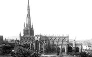
Bristol's Loveliest Church, St Mary Redcliffe.
St Mary Redcliffe Church. Bristol's loveliest church, St Mary Redcliffe, was described as 'the fairest, the goodliest and most famous parish church in England' by Queen Elizabeth I in 1574. Thanks to ...Read more
A memory of Bristol in 1880 by
Recollections Of Pitsea From 1941 Onwards
Born in Northlands Drive, Pitsea in 1938, my first recollection was aged 3 years when I remember being put to bed in a cot under the kitchen table during an air raid. We had an Andersen shelter in the ...Read more
A memory of Pitsea in 1940 by
Re. Where's Our Susan?
I was looking at the old Co-op photo of Widnes. I was amazed when I read about Susan. I too lived in South Street. I lived at number 4. It's been many years but I'm almost certain I know you all! Lol! By the way my name is Charlie I was 6 in 1960.
A memory of Widnes by
Early Childhood In Romford
I was born in 1953 and lived for the first 3 years in an old house in Junction Road (Number 8) with my parents and Mum's mum (Granny). The back garden of the house seemed to be a jungle and had its end boundary with ...Read more
A memory of Romford by
Captions
2,444 captions found. Showing results 985 to 1,008.

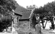
The church has a Norman nave and chancel, with Norman mouldings to the south door and chancel arch. The porch is Tudor.

The south porch dates from 1466. The tower has stone figures at the corners instead of pinnacles. The whole church was restored in 1872. The vicar in 1906 was the Rev John Brown.

We are looking towards Ouse Bridge with South Esplanade on the right.The view has remained virtually the same, except for the difference in the river traffic and a change of use for some of the

We are looking towards Ouse Bridge with South Esplanade on the right.The view has remained virtually the same, except for the difference in the river traffic and a change of use for some of the

Beckbury, just a mile or so to the south, can certainly be described as a village, and it still retains its pub, the Seven Stars.

As Reading expanded south, St Giles', decaying and small, proved unable to cope, and Christchurch was built in 1861-2.

At the south end of the village is Townend, a typical Lakeland statesman's house, now in the care of the National Trust.

Eamont Bridge, just south of Penrith on the A6, takes its name from this splendid three-arched bridge across the River Eamont.

In this view we look past the Horse and Jockey pub towards the south of the village; the church is beyond the high tree on the left.

Since 1955 a new residential block has been built in the background of the picture, whilst a new library to the south of the chapel has appeared.

Ahead is the 17th-century timber-framed White Horse and the Victorian South View Cottage. The road to the left leads to the former Independent Chapel of 1750.

Carfax stands at the crossing point where the original north to south and east to west routes ran through Oxford.

By 1955 a new station had been built on the corner of Brooke Road and South Street. In recent years this has been considerably modernised.

A half-mile south along London Road, it was built in 1861 by the school usher, Rev W J Earle, in brick with a subdued polychromatic treatment by a Birmingham architect.

There is now a scheme to encourage more livestock farming on the South Downs.

Acomb House, to the south of the village square, was built in the 1730s, though it is thought to incorporate the remnants of an earlier house.

This view, from the end of a path leading past the Brownlow Arms to the west bank of the Trent, looks across the tidal river from Nottinghamshire to South Clifton in Lincolnshire.

On the right can be seen the Romanesque doorway leading to the South Transept, a very fine example of 12th century stonework. The building in the middle distance is the Synod Hall, now Dublinia.

On the north side the walls are about two feet out of true because of subsidence and the collapse of the south walls in 1569.

Goodworth Clatford lies a couple of miles to the south of Andover. We can see horses trotting through the village (centre). The name 'Clatford' means 'ford where burdock grew.'

The photographer in this instance was looking across to the south bank, recording for posterity a scene which no longer exists: only the bridge survives.

This view looks south-east towards the Westbury White Horse.

Sawley Bridge Marina, on the Sawley Cut of the River Trent, south of Long Eaton, was already starting to cater for the ever-increasing boating trade when this photograph was taken in the mid-50s.

Whitford church, dedicated to St Mary and St Beuno, is just over 5 miles to the south east of Prestatyn.
Places (15471)
Photos (5054)
Memories (1580)
Books (1)
Maps (2499)

