Places
17 places found.
Those places high-lighted have photos. All locations may have maps, books and memories.
- Bridge End, Oxfordshire
- Bridge End, Lincolnshire
- Bridge End, Essex
- Bridge End, Bedfordshire
- Bridge End, Clwyd
- Bridge End, Warwickshire
- Bridge End, Surrey
- Bridge End, Durham (near Frosterley)
- Bridge End, Northumberland (near Hexham)
- Bridge End, Hereford & Worcester (near Tirley)
- Bridge End, Hereford & Worcester (near Bosbury)
- Bridge End, Shetland Islands
- Bridge End, Cumbria (near Carlisle)
- Bridge End, Northumberland (near Hexham)
- Bridge End, Devon (near Kingsbridge)
- Bridge End, Devon (near Sidmouth)
- West End, Yorkshire (near Pateley Bridge)
Photos
40 photos found. Showing results 81 to 40.
Maps
520 maps found.


Books
2 books found. Showing results 97 to 2.
Memories
1,928 memories found. Showing results 41 to 50.
Dinham Weir
The Ludlow weirs were navigation Flash Lock weirs until the railways came to the Teme valley. Sailing Trows from the Severn worked up the river with wheat for the mills from Gloucester returning with flour for the villages and iron bar ...Read more
A memory of Ludlow in 1860 by
George Maddison
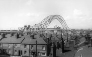
thanks to this photograpgh i have identified a photograph of my late father taken in 1954 we all thought it was the hexham bridge but now know it is the bywell bridge by the number and type of arches over the river thanks philip maddison
A memory of Bywell in 1954 by
Building The Bridge
I was sat in my classroom at the parish school in church street and I had just put away my plastic counters after a hard maths lesson ,I was only 5 ( and 1+1 was very hard)my teachers name was mrs oats she was lovely and as I ...Read more
A memory of Runcorn in 1961 by
Arthog
From early 1960s onwards: At school in London we had 2 summer holidays at Min-y-Don. The first time we travelled by coach, we got lost and arrived in the dark. The following year we came by train from Paddington. We had to change at ...Read more
A memory of Arthog by
Lockwood Beck And Lingdale
Hi Everyone what a lovely photo of the reservoir. My family lived at the reservoir for many years. My father and his father were born there with his sisters. He was Henry Marshall born 1923. He was the 3rd Henry ...Read more
A memory of Boosbeck by
39londonroad
I was born in Hackbridge in 1944. I lived there until 1953 when my grandparents, aunts, uncles, and cousins put me on a plane on May 2 to join my father who had emigrated to Canada the year before. My mother, who had lived in ...Read more
A memory of Hackbridge in 1944 by
"Any Old Iron"
This photo brings back lots of memories for me as it shows High Road, Woodford Bridge which is where the old-fashioned ironmongers that my family owned was situated. There had been one on the site since the beginning of the ...Read more
A memory of Woodford Bridge in 1974 by
Little Sutton In 1950s And 1960s
What memories your comments conjure. How I loved the 'rec' as a child. We started on the 'baby swings' and progressed to the 'big swings' and see-saw and round-a-bout. The old shelter there was a favourite ...Read more
A memory of Little Sutton in 1960 by
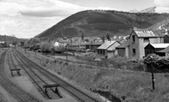
Pont Y Waun
This is a view of Pont-y waun from Pont-y-waun bridge. If you look closely you can just make out the canal that ran parallel to the railway line. In the background is the Rhwsg mountain which I had the pleasure to climb frequently as a kid and even recently on my mountain bike!
A memory of Pontywaun in 1970 by
Where I Was Born
I was born on New Road, Crickhowell in the very early 1930s. My mother was born in Bridge Street, number 28, where my grandparents lived. My grandfather worked on Glanusk Estate for the then Lord Glanusk until he died. The ...Read more
A memory of Crickhowell by
Captions
1,770 captions found. Showing results 97 to 120.

The Exel Bowling Lanes replaced it and live entertainment moved to the end of the pier.

After a serious fire in 1975, the 18th-century building with the black cross facing us at the end of Bridge Street, formerly the Crown Inn, was demolished; this caused a major outcry.

This renowned thoroughfare, a continuation of Oxford Street, links the West End with the City. It takes its name from the Oldbourne Bridge which once spanned the Fleet River.

We end this chapter in St Peter Street, which originally led to the old wooden bridge replaced by the present one further west.

North Walk was destroyed when the Lynton and Barnstaple railway came through in 1898. Subsequently, a road was built linking The Strand with the end of High Street.

This photograph shows the Cannon Street end of King William Street, which heads south-east from the Mansion House towards London Bridge.

This view looks south-westwards from Broad Ledge to Long Ledge (foreground) below Gun Cliff to the Guildhall (top right), the Fossil Depot beside Buddle Bridge and the Assembly Rooms (centre), with the

At the junction of Gold Street and Bridge Street, with The Drapery to the right, this view looks west from the end of Mercers Row.

In this view the northern wing, which turns the corner into Bridge Street, is still virtually brand new.

Ware is packed full of interesting buildings and streets, but nothing it has to offer surpasses Amwell End.

By 1900 the tenements appear; their gable-ends were obviously a popular advertising site.
This photograph shows the Cannon Street end of King William Street, which heads south-east from the Mansion House towards London Bridge.

Just behind the camera at the north end of the town lies Yarm Bridge, reminding us that for centuries the River Tees was navigable; Yarm operated as an important port, until it was superseded later by

Its rugged stone bridges and its proximity to the Pennines make it a most picturesque line. Carnforth is towards the northern end; the top section was abandoned after the M6 motorway was built.

Serving both a rural area round about, and hundreds of overseas ports by way of trade, Plymouth reached its mercantile heyday in Victorian times.

Five years after the end of the Second World War, there was still much evidence of the severe bombing around the cathedral.
Serving both a rural area round about, and hundreds of overseas ports by way of trade, Plymouth reached its mercantile heyday in Victorian times.
Serving both a rural area round about, and hundreds of overseas ports by way of trade, Plymouth reached its mercantile heyday in Victorian times.

The Square lies at the north end of the Long Bridge. The building to the right is the red façade of The Athenaeum, built in 1888, which houses the museum and a collection of fossils.

The branch railway from Weymouth to Portland (left) was built westwards from Weymouth railway yard (centre right) in 1862 and opened in 1865.

This is the Roman canal from the Brayford Pool in Lincoln to the river Trent at Torksey, and it is the oldest canal in England.
This is the Roman canal from the Brayford Pool in Lincoln to the river Trent at Torksey, and it is the oldest canal in England.

This view shows the junction of Boar Lane and Briggate, looking towards the Corn Exchange. In the 17th century Leeds held its cloth fairs at the bottom end of Briggate every Tuesday and Saturday.
This view shows the junction of Boar Lane and Briggate, looking towards the Corn Exchange. In the 17th century Leeds held its cloth fairs at the bottom end of Briggate every Tuesday and Saturday.
Places (17)
Photos (40)
Memories (1928)
Books (2)
Maps (520)

