

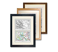
Quad Framed Historical Map Print

The ultimate survey - four Ordnance Survey maps showing how the landscape has changed from the early 1800s to the modern day. Centred on a postcode of your choice.
See the differences from the 19th-century up until today using four different Ordnance Survey series spanning two centuries. Printed to order, your chosen maps will be set in a cream mount and a choice of solid wood frame. Supplied ready to hang.

Samples of Maps Used:

OS Old Series
1805-1874

OS Revised New Series
1896 - 1912

OS New Popular Edition
1946 - 1948

OS Present Day
2015 - 2018
Configure Your Map
To create your postcode centred framed print, simply enter your postcode below to start. Then choose your frame and add to your basket - nice and easy! We cannot currently offer a preview of your map, but have included some samples above so you know the kind of area covered.
1. Specify Postcode Centre:
You might also like:
Take a look at our range of other gifts and keepsakes that can be personalised on a postcode!
Postcode Centred
- Framing
- Photo Prints
- Sheet Maps
- Old Maps
- Canvas
- Mounting
- Prints-only
- Calendars
- Postcode Centred
- Multi-Photo
- Photo Books
- Jigsaws
- Presentation
- Mugs
- Cushion Covers
- Tea Towels
- Gift Cards
- Wallpaper
All Departments
- Photo Prints
- Sheet Maps
- Old Maps
- Calendars
- Postcode Centred
- Photo Books
- Jigsaws
- Mugs
- Cushion Covers
- Tea Towels
- Gift Cards
- Wallpaper
Framer?
Trade discounts available!

Shopping with us


