Places
36 places found.
Those places high-lighted have photos. All locations may have maps, books and memories.
- Hest Bank, Lancashire
- Kents Bank, Cumbria
- Copthorne Bank, Sussex
- Banks, Lancashire
- Sutton Bank, Yorkshire
- Astwood Bank, Hereford & Worcester
- Dacre Banks, Yorkshire
- Ten Mile Bank, Norfolk
- Matlock Bank, Derbyshire
- Bank, Hampshire
- Hesketh Bank, Lancashire
- Far Bank, Yorkshire
- Bank's Green, Hereford & Worcester
- Banks, Cumbria (near Lanercost)
- Banks, Dumfries and Galloway (near Kirkcudbright)
- Bunsley Bank, Cheshire
- East Bank, Gwent
- Hanwood Bank, Shropshire
- Hoole Bank, Cheshire
- Howbeck Bank, Cheshire
- Papermill Bank, Shropshire
- Pickup Bank, Lancashire
- Malkin's Bank, Cheshire
- Meal Bank, Cumbria
- Sandy Bank, Lincolnshire
- Scilly Bank, Cumbria
- Steel Bank, Yorkshire
- Bogs Bank, Borders
- Alsagers Bank, Staffordshire
- Bury's Bank, Berkshire
- Brandon Bank, Cambridgeshire
- Cat Bank, Cumbria
- Cadney Bank, Clwyd
- Dawley Bank, Shropshire
- Dean Bank, Durham
- Lade Bank, Lincolnshire
Photos
1,065 photos found. Showing results 61 to 80.


Maps
786 maps found.


Books
15 books found. Showing results 73 to 15.
Memories
6,742 memories found. Showing results 31 to 40.
The 50s And 60s
I lived with my parents, Ralph and Joan, "Bindy" and sister Judy, on Birchway, off Ack Lane East, then we moved to 17 Atholl Road. There were several families with children who my sister and I spent a lot of time with - Johnny ...Read more
A memory of Bramhall by
My Grandad Jim
My name is Kerry & my favourite memory of Coalville when I was younger is my Grandad, his name was Jim Watts. He was a coal miner for quite a few years & he was also Mayor of Coalville. I remember going to the dog track ...Read more
A memory of Coalville by
Not Uplyme Mill
The picture titled "Uplyme Mill 1892" is incorrect. The location is Lyme Regis and is called Higher Mill along the banks of the River Lym in an area known as "Monkeys Rough" locally, opposite the original "Jericho" and "Paradise ...Read more
A memory of Lyme Regis in 1890 by
Childhood Memories
This view brings back many childhood memories, I was born in the cottage on the right hand edge of the picture, in 1947, growing up on the farm there, and have lived within three miles of the area for the majority of my life.
A memory of Ticehurst in 1947 by
My Memories Of Broadstone
My earliest memories of Broadstone stem from about 1937 when I was five years old. We lived in Southbourne at the time and frequently went to Broadstone at weekends to visit my "aunt Flo" and her family who lived at ...Read more
A memory of Broadstone by
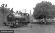
Round The Rec
Hi there I remember the day that this engine arrived in the rec. It was a source of great entertainment for us youngsters particulary, as originally everything was accessible. I remember climbing up on the footplate and seeing a ...Read more
A memory of Daventry in 1965 by
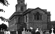
My Wedding Day
Hi there, I was married in The Church of The Holy Cross on November 1st 1958. It was a very cold day as you would imagine, being Winter time, but it was a lovely sunny day. I remember walking up to the big doors on my father's arm ...Read more
A memory of Daventry in 1958 by
Families
On the 27th of December 1956 my ex-husband KEITH GEORGE JEARY was born at 6 UPPER CLOSE where he lived with his parents until we were married at Holy Trinity Church on the 6th of November 1982 - both of my children Emily and Dominic were ...Read more
A memory of Forest Row in 1956 by
First Memories
My father, Richard (Dick) Cherrington was the village policeman in Nether Wallop during World War 2 and I was born in the Police House in the village in August 1944. My first memories ever were of an apple tree in our garden ...Read more
A memory of Nether Wallop in 1947 by
98 & 100 High Street
These two shops in the High Street in Crowle were owned by my grandmother Rose Raper. They were handed down to my father and aunt. My dad Raymond Raper had the grocers shop at number 98 and we lived above the shop until I was ten ...Read more
A memory of Crowle by
Captions
2,423 captions found. Showing results 73 to 96.

This view westwards shows (from left to right) the Midland Bank, Mac Fisheries, Cathedral Antiques (the Abbey National Building Society today), a solicitor's premises, and Traveller's Joy travel

Stramongate Bridge was also known as Miller or Mill Bridge, because it linked the mills on the eastern bank of the River Kent to the 'Auld Grey Town' on the other bank.

Mill Bank, or simply 'Loftus Bank', forms the approach to Loftus from Carlin How and, to this day, tests the skills of even the most careful driver, particularly in the winter months.

The cross sands route from Hest Bank and Arnside comes ashore by Kents Bank station, which is regularly used in summer by those groups of walkers who have been led across Morecambe Bay,

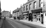
We are looking down the High Street towards Barclays Bank.

Banks abound in Granby Street: the Italianate National Westminster of 1869, the Midland, a Gothic creation with its French pavilion roof, and the Yorkshire Penny Bank opposite the Grand Hotel is probably

The ferry has long gone, but this view from the Oxfordshire bank looking north-east captures the river's character well. To the right is the ferry slipway behind the St George and Dragon pub.

A little further downstream, just through the railway bridge, the view down river from the Staines bank has changed; now there is extensive housing development on both banks, much fortunately still hidden

The bank at the left has become the District Bank, and the building also houses the Inland Revenue.

This photograph of Roebuck Ferry House is a reminder of the days when an un-accommodating landowner refused access to the Berkshire bank of the Thames.

This is a general view of Kendal from the south, with the Lakeland hills in the background.The town of Kendal was founded on the west bank of the River Kent, although the earliest settlement around

Samuel Greg's Quarry Bank Mill stands on the banks of the Bollin where it flows through a wooded glen. Originally water-powered, the mill remains intact, and is now in the care of the National Trust.

The scene is a near traffic jam at the Bank. The photographer is standing on the Mansion House balcony looking directly at the Royal Exchange.

The village was confined to the south bank of the river; the development of the north bank did not take place until the building of the Victoria Bridge.
The village was confined to the south bank of the river; the development of the north bank did not take place until the building of the Victoria Bridge.

This photograph shows the village of Streatley on the left bank of the Thames. An old wooden bridge linked the village with Goring on the opposite bank until it was replaced in the 1920s.

The NatWest Bank now occupies the left-hand corner building, whilst on the right the street was completely redeveloped in the 1980s with estate agents' offices and Lloyds Bank.

The Green Bank Hotel, on the south bank of the Penryn River, was built in 1785 to cash in on the trade brought to the town by the mail packets.

On the corner is the London and County Bank, which, in time, will become the National Westminster Bank.

7 miles from Clitheroe on the banks of the River Hodder amidst moorland, Slaidburn is a popular village with walkers and cyclists. The view from the bank shows the 15th-century church of St Andrew.

The bank on the right, 1920s extensions to two houses, went in 1975. Its drab replacement Nat West Bank is now (in 2000) Methvens booksellers.

Great Mitton is on the north bank of the river, and Little, or Lower Mitton on the south bank, with the River Ribble (which we can see here) in between.

The Bankes Arms is named after the prominent Dorset family, which included Lady Bankes, the 17th-century defender of the castle.

A 20th-century means of producing power shares the banks of the Orwell with vessels which harness one of the oldest forms of power.
Places (158)
Photos (1065)
Memories (6742)
Books (15)
Maps (786)

