Places
Sorry, no places were found that related to your search.
Did you mean: north ness or na h ness or nook ness ?
Photos
12 photos found. Showing results 1,081 to 12.
Maps
9,582 maps found.


Books
Sorry, no books were found that related to your search.
Memories
4,597 memories found. Showing results 541 to 550.
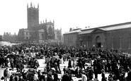
1973 Demolition Year For The Market Buildings
I arrived in Wolverhampton when demolition of the market buildings was under way. The buildings in front of the church (in the photo) must have already been long gone, but the buildings on the side ...Read more
A memory of Wolverhampton
The School Of The Holy Child, Laleham Abbey
heads the label in a dictionary of music that I received as a prize in Upper IA. No date. It must have been 1955. My name was/is Margaret Morley. I joined the school on my return from Malaya in 1951, followed ...Read more
A memory of Laleham
Parkside. Memories Of The 50's And 60's
My name is Dennis Walsh, I was born in 1953 at 62, Park Side. I lived there until Dec 1965 when we moved to Sydney Australia. My earliest memories are of our house, which backed onto the park. It seemed like a ...Read more
A memory of New Haw by
The Awakening
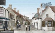
On the right of the photograph the second shop belonged to Arthur Sansom, the Newsagents and Confectioners. It has a sign board above the shop front: PICTURE POST. In the Easter holidays of 1959 at the age of 14½, I took my first ...Read more
A memory of Locksbottom
Teenage Memories
I spent most of my leisure time at Seaburn in the 1950's and early 60's.It used to be a wonderful place to visit,the Seaburn Hotel,Popular Cafe,Notarrianis (we spent a lot of time here drinking hot orange).The fairground was a big ...Read more
A memory of Seaburn by
Life Above Corals Coal Shop
my parents moved to an empty flat above the coral coal shop in bank street.my Father worked for corals coal as a delivery driver.The flat was an extra bonus i was born in Dover 1954 and when we left there we moved to a ...Read more
A memory of Ashford
St Pauls Cray School Memories.
I was living at the time at the top of what was called Chalk Pit Avenue, then an unmade and often muddy road in bad weather, at the bottom of the garden was a field and across the field was a fairly large house ...Read more
A memory of St Paul's Cray by
Kennylands
In old age, I like to remember my school days at Kennylands Camp. It was the first to be used for evacuation and I was in the first intake. It was a delightful spot and within walking distance of a lot of Thames villages and towns. ...Read more
A memory of Sonning Common by
Wargrave In Berkshire About 1966.
I used to work for a company called David Greig, they had provisions shops in many towns with the flagship shop at that time (mid sixties) being the one at Reading. I worked mainly in the Orpington shop and was asked ...Read more
A memory of Wargrave
Park Lane Junction With Wembley High Road
Oh yes I can recall this photograph really well. I was born in Logan Road, just off Preston Road and my mother and family visited Wembley High Road to frequently. Just before I married in 1971 the site of ...Read more
A memory of Wembley by
Captions
1,652 captions found. Showing results 1,297 to 1,320.

It was the second Anglican church in the town and is situated high on the moor side of town.

Seen here from beyond the River Parrett, it once had a castle; now it is crowned by the altered medieval tower of St Michael's church, another example of this dedication on a hill site.

At the right in both views is Temple Island, the start of the course, with its gar- den temple by James Wyatt, erected in 1771 as a fishing lodge for Sambrook Freeman of Fawley Court.

To the left is the Queen's Hotel with its central flag-poled turret. Built in 1864, it replaced a much older hotel, itself a replacement for an inn, the Antelope, which existed here in 1538.

Now a tree-clad hilltop fort, this is another example of the many forts built by the Iron Age people. To date it has never been excavated.

The first stone bridge over the Wharfe was constructed in 1233; the bridge we see today was widened in 1826 to cope with the increase in livestock traffic to the town market.

He was close to both Henry V and Henry VI, and was responsible for the building of many fine churches; he also suppressed Jack Cade's Kentish rebellion after his appointment as Chancellor

The last of the transatlantic paddle-liners, Cunard's 'Scotia', was finally withdrawn in September 1875, while the last transpacific paddler managed to linger on for another six years.

By the end of the 19th century, New Street was both the principal business street in the town and the best for shopping and entertainment.This view is from Paradise Street.

While boys and girls are taught separately, the educational organisation for both is similar, with Junior, Lower and Middle Schools and a Sixth Form.

Cenarth, on the Teifi, is set in a spectacular gorge with a number of waterfalls, and is famous as one of the last places in Britain where licensed coracles were used, both for salmon fishing and (as we

Both Sheep Market and All Saints Street lead down to what was the Great North Road, but Stamford has since been bypassed. The town bus station is on the right, on the site of Stamford Castle.

The name of the town does not refer to any beach, but comes from the Old English word 'beck', meaning 'stream'. Clayhithe was the harbour of Waterbeach; the word 'hythe' means 'landing-place'.

The London & Provincial Bank established itself c1883, relocating to a vacant school building on the corner of Stanwell Road c1886. It became Barclays (left) after bank amalgamation of 1919.

Drummond Castle Gardens is noted for its many rare shrubs and trees, but it also has another unusual feature.

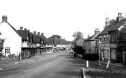
Here we have a closer view of the quiet main street; note the sign of the Golden Cocker Café by the street lamp.

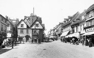
In the 17th century the building that is now The White Hart Royal was a manor house, and Charles I stayed there in July 1644 after the Battle of Marston Moor.

Next to the Arch is the Baker's Arms Hotel, another 18th-century building.

The photographer is looking east from the top of High Street, where there is now a roundabout, with the churchyard walls and lime trees on the left. The wall and railings have now gone.

At the west end of the High Street, London Road curves away north-west downhill.

Once this lock on the Aire and Calder Navigation opened at 10am on 20 July 1826, trade boomed between the North Sea port of Hull and the West Yorkshire industrial heartland.

This is another viewpoint on the Edge, from which it is usually possible to see the Cage in Lyme Park.

On the extreme left is Palmers, with John Bull tyres and cycle lamp batteries on display in the window.

Two miles south-west of Michelham Priory, further downstream along the Cuckmere River, we reach Arlington, another scattered village of farmsteads bisected by the meandering river.
Places (0)
Photos (12)
Memories (4597)
Books (0)
Maps (9582)

