Merry Christmas & Happy New Year!
Christmas Deliveries: If you placed an order on or before midday on Friday 19th December for Christmas delivery it was despatched before the Royal Mail or Parcel Force deadline and therefore should be received in time for Christmas. Orders placed after midday on Friday 19th December will be delivered in the New Year.
Please Note: Our offices and factory are now closed until Monday 5th January when we will be pleased to deal with any queries that have arisen during the holiday period.
During the holiday our Gift Cards may still be ordered for any last minute orders and will be sent automatically by email direct to your recipient - see here: Gift Cards
Places
36 places found.
Those places high-lighted have photos. All locations may have maps, books and memories.
- Shanklin, Isle of Wight
- Ventnor, Isle of Wight
- Ryde, Isle of Wight
- Cowes, Isle of Wight
- Sandown, Isle of Wight
- Port of Ness, Western Isles
- London, Greater London
- Cambridge, Cambridgeshire
- Dublin, Republic of Ireland
- Killarney, Republic of Ireland
- Douglas, Isle of Man
- Plymouth, Devon
- Newport, Isle of Wight
- Southwold, Suffolk
- Bristol, Avon
- Lowestoft, Suffolk
- Cromer, Norfolk
- Edinburgh, Lothian
- Maldon, Essex
- Clacton-On-Sea, Essex
- Felixstowe, Suffolk
- Norwich, Norfolk
- Hitchin, Hertfordshire
- Stevenage, Hertfordshire
- Colchester, Essex
- Nottingham, Nottinghamshire
- Bedford, Bedfordshire
- Bury St Edmunds, Suffolk
- Aldeburgh, Suffolk
- St Albans, Hertfordshire
- Hunstanton, Norfolk
- Chelmsford, Essex
- Bishop's Stortford, Hertfordshire
- Peterborough, Cambridgeshire
- Brentwood, Essex
- Glengarriff, Republic of Ireland
Photos
9,107 photos found. Showing results 1,181 to 1,200.


Maps
181,006 maps found.


Books
11 books found. Showing results 1,417 to 11.
Memories
29,072 memories found. Showing results 591 to 600.
Visiting As A Child
My memories of Coulsdon are very vague as I live in Scotland. My Father met a wonderful man named Bernard during the 2nd world war.who came from Coulsdon. Bernard was over 7 feet tall and this is the only thing I remember ...Read more
A memory of Coulsdon in 1953 by
Henry Tingey Ancester
My great grandfather Henry Tingey, was born November 18, 1819, in Biggleswade, Bedfordshire. He was the son of James Tingey and Elizabeth Boniss. James and Elizabeth, and family later moved from Bigglewade, Bedfordshire, ...Read more
A memory of Biggleswade by
Childhood Memories Of Yapton
i have very fond memories of visiting my grand parents in yapton, who lived opposite the church in the cottages.my grandfather Roy, i believe was the villiage carpenter and my nan alice was helper in the church, and ...Read more
A memory of Yapton in 1972 by
Picnics In The Park
MY MEMORIIES OF YSTRAD PARK AS A CHILD ' MY MOTHER AND HER FRIENDS WOULD GATHER ALL US CHILDREN AND WALK TO THE PARK WHERE WE WOULD HAVE A PICNIC AND PLAY ALL DAY MOST PEOPLE GOING BACK TO 1958 WILL REMEMBER THE ...Read more
A memory of Ystrad Mynach in 1954 by
1959 To 1964
In the bottom left corner of the photo is a row of four white bungalows. My father --Ron Bartlett built these and several others on the estate from about 1959 onwards. We lived in the top one. The house immediately to the right of ...Read more
A memory of Mochdre by
Heather And Gorse Clog Dancers Entertain At Chudleigh
Chudleigh hosts a wonderful Christmas late night shopping evening each year when the Christmas lights in Fore Street are switched on. The shops stay open until late evening and their windows ...Read more
A memory of Chudleigh in 2007 by
Burials At St Mary's
My maternal grandmother was born in Selby. Annie McMenamin ( McManum or various spellings depending on who wrote the name down !) She lived in Hutchinsons Yard, Selby with her mother Catherine, father Michael, sisters Mary, ...Read more
A memory of Selby in 1953 by
Schooldays
I have fond memories of marching up to St. Margarets Church from St. Margarets Junior and infant school, Richmond Rd. in the sixties and early seventies. We had to hold hands, and the operation of crossing the Warwick Road safely was a ...Read more
A memory of Olton by
Going To School
I suppose it was round about 1955 not sure. I remember going to school and often the headmistress used to pick us up, and we used to sit in the dicky seat. I remember picking rose hips. I remember we had lots of friends. My name ...Read more
A memory of Stanhope in 1955 by
Summer Days Boating On The Lake
Wonderful memories this photo brings back. In the 1950's after school we would take girls out in the boats...then eat ice cream with soft drinks from the Grange cafe. Beddinton Park and the Grange were the best of times for young romance in the summer. Ron Shelley
A memory of Beddington by
Your search returned a large number of results. Please try to refine your search further.
Captions
29,158 captions found. Showing results 1,417 to 1,440.

It was Sir William Keith, Marischal of Scotland, who built a tower house at Dunnottar in the late 14th century, and is said to have been excommunicated for his troubles by the Bishop of St Andrews for

Located at the western extremity of the South Downs, Buriton captures the essence of the traditional English village.
This dramatic view of the Calvary, which lies to the north of the Abbey buildings, was taken shortly after its completion, with the addition of the figure of Christ in 1965, although it was begun in 1847

A great deal of money was spent on the buildings of this charitable foundation.

The hotel was one of the landmarks of Nottingham for centuries and it is a matter of conjecture how it came by its unusual name.

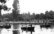
This ornate pleasure craft looks perilously low in the water, but the throng of passengers seem quite oblivious of the rising water levels.

The clock tower dominates the main street of this West Cumberland town.

The village stands on the skyline above the approach to the popular golden sand of Crantock Beach.
This ornate pleasure craft looks perilously low in the water, but the throng of passengers seem quite oblivious of the rising water levels.

The Lady Chapel Window contains a rare 15th- century fragment of glass known as the 'Five Wounds Window', depicting the wounds of Christ.

This spectacular swell, stirred up by the prevailing south-westerly winds, demonstrates not only the need for the massive solidity of these stone and wooden jetties against the power of the sea, but

For years the harbour and sea have provided employment for many of Southwick's inhabitants, and in 1871 the increase in population at Southwick and Fishersgate was attributed to oyster-dredgers and other

Two local residents, one mounted on an early motorbike, pass the time of day by the Prince of Wales pub in the centre of the village.

South of Boroughbridge is the old Roman town of Aldborough - Isurium Brigantum.

Church Farm (right) of c1480 is a hall house with cross wings. The parlour wing is double jettied, with the arms of the de Ufford family, Earls of Suffolk, under the oriel window.

Formerly known as the Griffin, the Bold Arms takes its name and heraldic device from one of the two families that owned most of North Meols for many centuries.

This early picture of the beach at Ramsgate shows the benches that were precursors of the modern deck chair and a few bathing machines. Ramsgate Sands Station is in the centre of the picture.

The building on the extreme right of this photograph combines two essential services – the local library and the police station, though neither is open full- time.

In front of St Giles' Church is the Buttercross (1734), used over the centuries for the sale of local dairy produce; it replaced the cross of St Oswald.

Hever is intimately associated with Anne Boleyn, who spent her childhood here in the company of her father Sir Thomas Bullen, the Earl of Wiltshire, whose tomb is at the little church of St Peter.

Away from the tourist area of Beach Road the little village of Hemsby remained unspoilt for many years. Still standing without change is St Mary's.

Looking from South Street the general appearance of Victoria Road has changed little in the last 50 years.

This is a street mainly of 16th- or 17th- century timber-framed cottages.

This unforgettable village cupped in a hollow with a large wayside pond is the home of All Saints' Church.
Places (6814)
Photos (9107)
Memories (29072)
Books (11)
Maps (181006)

