Places
26 places found.
Those places high-lighted have photos. All locations may have maps, books and memories.
- Cemmaes Road, Powys
- Six Road Ends, County Down
- Road Weedon, Northamptonshire
- Severn Road Bridge, Gloucestershire
- Roade, Northamptonshire
- Berkeley Road, Gloucestershire
- Harling Road, Norfolk
- Road Green, Devon
- Builth Road, Powys
- Cross Roads, Yorkshire
- Steele Road, Borders
- Cross Roads, Devon
- Four Roads, Dyfed
- Road Green, Norfolk
- Biggar Road, Strathclyde
- Clarbeston Road, Dyfed
- Five Roads, Dyfed
- Eccles Road, Norfolk
- Grampound Road, Cornwall
- Morchard Road, Devon
- Wood Road, Greater Manchester
- Four Roads, Isle of Man
- St Columb Road, Cornwall
- Clipiau, Gwynedd (near Cemmaes Road)
- New Road Side, Yorkshire (near Silsden)
- New Road Side, Yorkshire (near Cleckheaton)
Photos
14,329 photos found. Showing results 2,641 to 2,660.


Maps
476 maps found.
Books
5 books found. Showing results 3,169 to 5.
Memories
11,058 memories found. Showing results 1,321 to 1,330.
My Memories Of Salford
I was born in the upstairs back room of my maternal Gran's house at 20 John Street, Pendleton. I was told there was an air raid going on at the time. My first school was John Street where there was a play ground on the roof, ...Read more
A memory of Salford in 1951 by
Growing Up In Filton
I was born in Plymouth of Welsh parents, there was no work in Newport Wales when my Father got out of the Navy, so, we moved to my Grandparents house in 50 Wallscourt Rd Filton, until our house 13 Canberra Grove Filton became ...Read more
A memory of Filton in 1966 by
Floating Coffins
South Wingfield Church is situated right beside the river and it was reported to me when I was looking round the graveyard (I'm a fam hist fan) that they have /had problems when the river flooded disturbing the graves and ...Read more
A memory of South Wingfield by
Wonderful Years
Living on the island was like living in paradise - it seemed like a constant holiday! I remember walking from 'Danehurst' along Pitts Lane across Binstead Road and up Cemetary Road to school every day. I loved walking to the ...Read more
A memory of Binstead in 1955 by
Going To School
I walked past this clock every day on my way to school. Down past the clock on the left was a news agent where I learned to shoplift. Almost every day I would steal from them and never got caught. I also started stealing ...Read more
A memory of Chalfont St Peter in 1963 by
Life Around St Nicholas Church
When we were children we used to toboggan down St Nicholas Hill in snowy weather, which was wonderfully exciting as it is so steep. I was married in St Nicholas Church on 25th July 1959 which was an exceptionally hot ...Read more
A memory of Laindon in 1959 by
What A Bike Ride!
I was born in Whitwell (Herts) in April 1949 and started my schooling at St Pauls Walden CE School in September 1953. This the hill on which I lived. As I grew older I used to ride my bike to school (very little ...Read more
A memory of Whitwell in 1955 by
Esville Combeland Road
I was born in the house on the right hand side of the photograph.It was the home of my grandparents David and Lydia Howells who had moved to Alcombe during the depression.Both were staunch methodists and belonged to the ...Read more
A memory of Alcombe in 1946 by
Treowen Road
I was born in March ,1947 at 69,Treowen Road.It was a terrible winter,and the midwife who delivered me (Nurse Maiden) had to enter the house through the upstairs bedroom window because the snow was pilled up so high. I lived in treowen ...Read more
A memory of Crumlin in 1947 by
It Must Have Seemed Like Bluewater Then!
It was either a long walk or a ride on the 174 bus from Oxlow Lane shops to the Heathway. It surprises even now just what variety there was there, no need to have to travel miles to get a new shirt or the ...Read more
A memory of Dagenham in 1965 by
Your search returned a large number of results. Please try to refine your search further.
Captions
5,036 captions found. Showing results 3,169 to 3,192.

An old market town on the road to Lichfield, only seven miles from Birmingham, Sutton Coldfield hung on to its independence until annexed by its large neighbour in 1974.Though an important town in

This rural scene, about a mile east of the city centre along Monks Road, is now much changed.

On the right is the junction with Station Road. Under the Town Hall once stood an old 18th-century fire engine with wooden wheels, and also the old stocks.

On the left, Harbour Parade and Military Road have been widened and raised. Madeira Walk was officially opened on 6 April 1895.

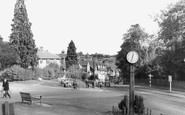
A fine view looking towards Shire Hall from the junction with Springfield Road. In the centre is the elegant Conduit of 1814, already reduced to acting as a traffic island.

The road was closed for four hours!

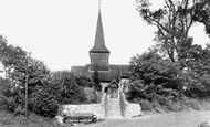
Since this picture was taken, a war memorial has been erected between the church and the road, and chiming apparatus was installed to commemorate the Coronation of Queen Elizabeth II in 1953.

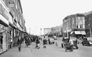
day.There are few cars parked along the street, but in those days private car ownership amid working families was still something of a novelty.The average wage was around £17 a week, and the annual road

Highcliffe, which traded as Highcliffe Methodist Guild Guest House, first appeared as a name in 1902 and now applies to a cul-de-sac seawards from Ulwell Road.

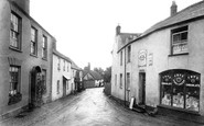
Despite one motor car, which is possibly a Ford 8, the shoppers here feel safe enough to saunter slowly up the road ignoring the pavement.

Leading to Runcorn Hill, Highlands Road and the surrounding area is a lovely part of the town. Of the cottages shown here only the one in the foreground still survives.

Overlooking the main road through the village is the church of the Holy Trinity. It was built in the 1880s to replace an earlier church dedicated to St Mary.

A Roman road marks one boundary. The parish church of St Mary (in the distance, centre) is famous for its 15th- century choir stalls transferred from Whalley Abbey.

This innocuous-looking road-junction was the backdrop for Dunmow`s pump riot of 1786.

Station Road was probably the first view of the town for most tourists, leading as it does from the railway to the sea front.

Looking from South Street the general appearance of Victoria Road has changed little in the last 50 years.

Herongate, in the parish of East Horndon, supposedly takes its name from a gate crossing the road near The Boar's Head.

Ruffetts Cottages, High Road, on the right probably date from the early 18th century and at one time belonged to the Shabden Estate.

Elmore Cottages still command the High Road opposite the village pond and crossroads but have been extended on the south side where the fence on the flint wall has been removed.

Bounded by Hazelwood Lane and High Road, the property appears in title deeds going back to the 17th century.

The village can be reached from a number of directions, but each one is a minor road, and consequently it remains a quiet spot.

The village sits below the North Downs on the main road between Dorking and Reigate.

The Village 1909 A handsome farm cart stands in the yard of a timber-framed two-storey building, in this small hamlet on the road between Tenterden and Hythe.

Consequently, the buildings on the far left were later demolished when the road was widened to ease the flow of traffic through Market Drayton.
Places (26)
Photos (14329)
Memories (11058)
Books (5)
Maps (476)

