Places
18 places found.
Those places high-lighted have photos. All locations may have maps, books and memories.
- Hythe, Kent
- Hythe, Hampshire
- Small Hythe, Kent
- Bablock Hythe, Oxfordshire
- Methwold Hythe, Norfolk
- Hythe, Somerset
- Hythe, Surrey
- Hythe End, Berkshire
- The Hythe, Essex
- Egham Hythe, Surrey
- West Hythe, Kent
- New Hythe, Kent
- Broad Street, Kent (near Hythe)
- Horn Street, Kent (near Hythe)
- Newbarn, Kent (near Hythe)
- Newington, Kent (near Hythe)
- Broad Street, Kent (near Hythe)
- Stone Hill, Kent (near Hythe)
Photos
360 photos found. Showing results 2,321 to 360.
Maps
101 maps found.
Books
10 books found. Showing results 2,785 to 10.
Memories
4,406 memories found. Showing results 1,161 to 1,170.
Memories From An Ex Sankey Lad 1963
I left Great Sankey at the age of 13, having lived at 37 Park Road with Mum and Dad and brother Chris, from the age of five. I initially attended Great Sankey Primary School on Liverpool Rd. I think where ...Read more
A memory of Great Sankey in 1963 by
St Mark's School
Like the former correspondent, I remember Miss Briggs (Fanny) who took the top class. The book she read was the autobiography of Albert Schweitzer; a missionary in Africa. Miss Briggs seemed to have eyes in the back of her head. ...Read more
A memory of Bredbury in 1955 by
French Kid
I was a french kid like can see and used to come in Hythe to my grand-parents house not very far from here in Hotspur Close. And I have meet a girl that was the grand daughter of Mr Stewart that as own the West Cliff Hall and ...Read more
A memory of Hythe in 1980 by
St Matthew's Church Warwick Street
I lived in Rugby from 1949 to 1952 having had contacts with the town since the early 1940s. My brother and sister and I, as children, used to attend this church which is the cloistered building back left of the ...Read more
A memory of Rugby in 1950 by
Royal Technical College Salford 1947 1950
I was born in 1933. My family lived in Nansen Street, Salford until 1939, when we moved to 27 Winster Ave off Littleton Rd where I attended St Sebastian School off Whit Lane througout the war. In 1947, by ...Read more
A memory of Salford in 1947
Middle Rainton Part 2
enjoyed a drink (bottled Guinness) at both “The Travellers’” and “The Tavern” almost daily throughout his life. In fact he is still remembered for his love of dominoes. To this day if someone plays double 3, the call ...Read more
A memory of Middle Rainton by
Middle Rainton Part 4
Pathways were made up of compressed dirt, West Street (facing West Rainton), Back Row (facing the Meadow’s Pit), Lewis Street running parallel with Back Row) and Cross Street running parallel with West Street). Krone ...Read more
A memory of Middle Rainton in 1940 by
Many Years Ago
I clearly remember those buildings by Hayden Hall. I used to live at the bottom of Wiltshire Lane next to the Woodman pub and the park opposite was my playground for a good few years. All that open space and the ...Read more
A memory of Eastcote by
Evacuee Nee Joan Waddington
I am now an 82 years old great grandmother and I have lived in Australia for many years. My family lived in Coventry, and when I was 12 my sister and brother and I were evacuated to Polesworth. At first the billeting ...Read more
A memory of Polesworth in 1943 by
Living At No 4 1947 1965
We moved to No 4 Barrington Court Cottages (the first cottage right of centre) in 1947. My father arrived as head gardener in April and mum arrived in July when I was three weeks old. Mum was disappointed to find she ...Read more
A memory of Barrington in 1947 by
Captions
4,899 captions found. Showing results 2,785 to 2,808.

Built in 1848 with funds raised almost entirely from public subscriptions, St Peter's was consecrated in July 1849 by the Bishop of Chester, Dr Graham.

Some said it was a plot by the Hun, and that the caterpillars had been dropped by Zeppelin.

As the industrialisation of weaving gathered pace, the town was eventually reached by the railway in July 1848. Within forty years a bigger station had to be built.

It has a plaque informing us that it was presented by the Indiana Limestone Co Inc to the people of Great Britain from 'The Stone City of the World', Bedford's namesake: Bedford, Indiana, in the USA.

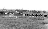
The views of the river from the principal bedrooms of the hotel were described by the diarist John Byng in the late 1790s as being highly agreeable with 'the smoothness of the wide water

The mistake was repeated by the poet John Keats, who referred to the stones as 'a dismal cirque of Druid stones upon a forlorn moor'.

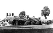
The Victorian commercial heart of this cul-de-sac village, strung out along the back lane into Melbury Park, was represented by the Melbury Osmond shop.

With farming in decline in the years after the Second World War, much land locally was sold in 1945, and is now owned by the Duchy of Lancaster.

This photograph was taken at the corner of Sambourne Road looking towards Carter's Corner, Nos 50–54A High Street and No 2 Portway, recently restored by the Warminster Preservation Trust.

The houses on the right of the street date from about this time, and were provided by Strutt for his workers at the nearby cotton mills, powered by the River Derwent.

Set on the banks of the Tennant Canal, the Abbey was founded in 1130 by the Norman baron Richard de Granville. John Leland, in the 16th century, described the abbey as 'the fairest in all Wales'.

On the opposite corner of Monk Street the agricultural merchants has gone, to be replaced by the new South Wales Electricity Board building.

A woman waits patiently against the fence by the pond; she has just come from the swimming pool area.
Set on the banks of the Tennant Canal, the Abbey was founded in 1130 by the Norman baron Richard de Granville. In the 16th century, John Leland described the abbey as 'the fairest in all Wales'.

Since the Reformation, the land hereabouts has been owned by the dukes of Bedford.

stands, known as Rayleigh Mount, and now belongs to the National Trust.The big 15th-century church of the Holy Trinity dominates this view of the town centre.The church contains Roman tiles re-used by the

Original plans for one grand avenue leading from Queen Street to City Hall proved fruitless - a development partially hindered by the Bute retention of the adjacent Greyfriars site.

By the 1860s annual output had risen to about 500,000 tons, though 350,000 tons of this was being mined at ten large collieries.

Rye, set on its sandstone isle rising from the flat fen of Romney Marsh, still presents something of a medieval picture, dominated by the great church of St Mary.

In 1835 a tower, part of the town wall defences, was incorporated into what was then Belmont House; its height was increased by the addition of a turret to match the rest of the building.

The display board to the right of the main shop window shows guide books and postcards of Cartmel Priory - the tree to the right is by the church.

Milk used to be carried around in churns on carts for customers to purchase it by the jug-full (centre left). This view is looking along residential Hartington Street.

The mill was owned by the Elmer family until 1953, when it ceased working. In 1963 it was blown down in high winds, only hours before it was to be dismantled to repair Holton mill.

The Celtic cross is the war memorial, erected by the Rev E R Yerburgh, on which the names are divided into Army and Navy personnel.
Places (18)
Photos (360)
Memories (4406)
Books (10)
Maps (101)

