Places
36 places found.
Those places high-lighted have photos. All locations may have maps, books and memories.
- Cardiff, South Glamorgan
- Barry, South Glamorgan
- Penarth, South Glamorgan
- Rhoose, South Glamorgan
- St Athan, South Glamorgan
- Cowbridge, South Glamorgan
- South Molton, Devon
- Llantwit Major, South Glamorgan
- Chipping Sodbury, Avon
- South Chingford, Greater London
- South Shields, Tyne and Wear
- Ayr, Strathclyde
- St Donat's, South Glamorgan
- Llanblethian, South Glamorgan
- Thornbury, Avon
- Llandough, South Glamorgan
- Fonmon, South Glamorgan
- St Nicholas, South Glamorgan
- Jarrow, Tyne and Wear
- Penmark, South Glamorgan
- Font-y-gary, South Glamorgan
- Maybole, Strathclyde
- Yate, Avon
- Oxford, Oxfordshire
- Torquay, Devon
- Newquay, Cornwall
- Salisbury, Wiltshire
- Bournemouth, Dorset
- St Ives, Cornwall
- Falmouth, Cornwall
- Guildford, Surrey
- Bath, Avon
- Looe, Cornwall
- Reigate, Surrey
- Minehead, Somerset
- Bude, Cornwall
Photos
5,607 photos found. Showing results 1,701 to 1,720.


Maps
2,499 maps found.


Books
23 books found. Showing results 2,041 to 23.
Memories
1,580 memories found. Showing results 851 to 860.
Growing Up In South Street
i grew up above the old gas showrooms between 1964 and 1975 wen we moved to clacton on sea i have recently had the pleasure to catch up with a few old school friends and people who knew me when i was dee jaying on a disco at the red lion pub in south street in the early 1980s
A memory of Manningtree in 1981 by
Kellys Bakery
Iwas born in Mitchell St,South Moor then moved to Craghead where I am sure there was a kellys bakery shop near the bus stop
A memory of South Moor in 1958 by
Living In Aveley 1948 68
Hello. I came across this site yesterday quite by accident and was really taken away by all the memories. Here are mine - I was surprised by the names and everything else that came back to me. Forgive me if I don't spell ...Read more
A memory of Aveley in 1948 by
Elmwood School
I attended Elmwood from 1969 - 1971 I moved from south London to Wallington in 69 and can remember walking through the park from Wallington to Hackbridge some of the names have come back to be after looking at some of the posts ...Read more
A memory of Hackbridge in 1969 by
Manc Schoolkids On The Prowl!
Remember being at a school in South Manchester called, Egerton, (where kids from Moss Side, Rusholme etc hailed from) and often, we'd be packed off, and taken to various parts of Cheshire to sniff with awe at freshly cut ...Read more
A memory of Delamere by
Southlands School,South Hill Ave, Harrow On The Hill.
I went to Southlands school harrow on the hill from 1958-1968 when it closed down. It was a victorian building and catered for day girls and borders. Many of the borders had parents living ...Read more
A memory of Harrow on the Hill by
The Plough Inn, Kibblesworth
This is for Margaret Elliot, I am from Kent but my adopted Grandad, Fred (Frederick Joseph) Johnson was the landlord of the Plough Inn during and after the Second World War and my mother and I were evacuated there and ...Read more
A memory of Kibblesworth by
Growing Up In Mitcham In The 1970's
Lovely to read some of the reminiscences of old Mitcham, it was such a lovely place to grow up in during the late sixties and early seventies, before changes started happening. I left in 1990, aged 25, before the ...Read more
A memory of Mitcham
Northolt
I lived close to Greenford Grammar (GCGS) and went to school there between 1963 - 1968. Many of my new schoolfriends lived in Northolt or North Greenford so I found myself spending much of my early teens there. In particular, I have fond ...Read more
A memory of Northolt
Blue Pencil Cafe, County Oak Crawley
Built as an Egg Farm and local produce outlet pre WW2 it became a Transport Café during the 1940's through the 1950's and into the 1960's. Well known on the A23. As a schoolboy I lived 100 yards south over the ...Read more
A memory of Crawley in 1954 by
Captions
2,476 captions found. Showing results 2,041 to 2,064.

This classic view of England's largest lake was taken from the south end of Loughrigg. Ambleside town is round the corner to the left.

Here the photographer looks north-west from near the hillfort that occupies the crest of the ridge, towards Poynings village and the scarp of the South Downs beyond at North Hill and Newtimber Hill.

On the south side of the street are several half-timbered houses of notable quality, with Shakespeare House and its prominent gable, and the Chequers Inn, both very evident.

By the end of the 18th century it had become the principal coal port in south Wales; all this from what half a century before had been little more than a few wharves.

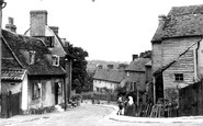
The road sign points down South Street which is almost invisible between the public building and the shops. Colmer`s Hill (right of centre) forms the distant skyline.

limestone crag overlooking the Towy Valley, the present Carreg Cennen dates from the late 13th century, though the site has historical links with the ancient commote of Is-Cennen, and sections of the south

The church itself has a Norman south aisle and sits in a delightful churchyard with the backs of timber-framed cottages on one side and the Misbourne in its valley on the other.

To the south-east of mediaeval Finchley, the High Road drops down from the North Circular Road between an almost standard series of parade shops built around the turn of the century, and past the Rex Cinema

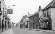
Further along the south side of the street (left of centre) is the Old Inn. West Court is behind the hand-cart.

This, the south gate to the castle keep, is today the main entrance, but it is thought that in the castle's heyday the north gate was the main access.

The parkland of 18th-century Welton Place sweeps south to the north bank of the Grand Union Canal, in its cutting leading to the east portal of the Braunston Tunnel.
building swept ever outwards, mainly to the north and east of the city centre, the 'scarlet fever' of private red-brick detached and semi-detached houses and bungalows filled the southern, south-western

The photograph looks south-east along the culverted stream bordering Station Road, with housing of the 1920s and 30s on the extreme right.

There are two prominent buildings of quality in the village, firstly the 13th-century parish church of St Peter and St Paul, and Langham Old Hall with its date stone of 1665 built into the south

Internally, the church has a good late 12th-century north arcade and a later south arcade. The great Gothic Revival architect George Edmund Street (1824-81) restored the building in 1852 and 1861.

This took development as far east as the old main road which had turned south to Walton, now marked by King Edward's Avenue.

This discreet little settlement in the parish of Stanton St Gabriel occupies a web of small lanes on the south-facing slopes of Hardown Hill and derives its name from three Old English words: 'mor' (

From the south-east, a look at the Institute, which has now sprouted a clock, put up in 1891 in memory of Thomas Cramp, the town's diarist and total abstainer.

Inside, the 14th-century north aisle has octagonal granite piers, while the 15th-century south aisle has piers of Polyphant stone with carved capitals.

The old Tudor timber-framed cottage formerly stood slightly further to the south, before being purchased by Epsom Rural Council in 1922 when it was dismantled and transferred to this present site.

Slyne, with Hest, also near Lancaster, saw Bonnie Prince Charlie's 1845 army of Scots passing on their way south.

All survives in Bridge Street, which leads out of the south- east side of the Market Place in the distance.

The view is south-eastwards to the Bay House Cafe and East Cliff (centre).

Half a mile south of the hamlet with the parish church and Chiddingly Place is another small hamlet, Muddles Green, where cottages fringe a small green.
Places (15471)
Photos (5607)
Memories (1580)
Books (23)
Maps (2499)

