Merry Christmas & Happy New Year!
Christmas Deliveries: If you placed an order on or before midday on Friday 19th December for Christmas delivery it was despatched before the Royal Mail or Parcel Force deadline and therefore should be received in time for Christmas. Orders placed after midday on Friday 19th December will be delivered in the New Year.
Please Note: Our offices and factory are now closed until Monday 5th January when we will be pleased to deal with any queries that have arisen during the holiday period.
During the holiday our Gift Cards may still be ordered for any last minute orders and will be sent automatically by email direct to your recipient - see here: Gift Cards
Places
26 places found.
Those places high-lighted have photos. All locations may have maps, books and memories.
- Town End, Derbyshire
- Town End, Buckinghamshire
- Town's End, Somerset
- Towns End, Dorset
- Town End, Merseyside
- Town End, Cambridgeshire
- Town's End, Buckinghamshire
- West End Town, Northumberland
- Bolton Town End, Lancashire
- Kearby Town End, Yorkshire
- Town End, Cumbria (near Grange-Over-Sands)
- Town End, Cumbria (near Bowness-On-Windermere)
- Town End, Yorkshire (near Huddersfield)
- Town End, Yorkshire (near Wilberfoss)
- Town End, Cumbria (near Appleby-in-Westmorland)
- Town's End, Dorset (near Melbury Osmond)
- Town's End, Dorset (near Swanage)
- Town End, Cumbria (near Ambleside)
- Town End, Cumbria (near Lakeside)
- Town End, Cumbria (near Kirkby Lonsdale)
- Town End, Cumbria (near Ambleside)
- Town's End, Dorset (near Bere Regis)
- West-end Town, South Glamorgan
- Townend, Derbyshire
- Townend, Strathclyde (near Dumbarton)
- Townend, Staffordshire (near Stone)
Photos
23 photos found. Showing results 501 to 23.
Maps
195 maps found.
Books
3 books found. Showing results 601 to 3.
Memories
3,720 memories found. Showing results 251 to 260.
My Youth
I lived in Tamar Drive and went to the local school, my senior school was Lennards Comprehensive. My best mates were Jenny Cutler, Shirley Jassec, Pat Madder. We spent alot of time roaming the streets, I remember the fair coming to town ...Read more
A memory of Aveley in 1960 by
Welshs Grocery Shop
When I was a little girl, my mother, Violet Helmore, would take me into Welsh's regularly to do her shopping. Biscuits could be bought loose then as could sugar tea etc. I always thought that I was a good little girl, ...Read more
A memory of Midsomer Norton in 1954 by
Vine Cottage And Blacksmith Shop
William Wright lived in Vine Cottage, Aston, there was a blacksmith shop beside the house, across the road was the orchard with many fruit trees and all the animals. I used to spend time there in the ...Read more
A memory of Aston in 1950 by
Life At Avon Carrow For A Yank Abroad
I moved into Avon Carrow in the Spring of 1970. I was stationed at RAF Croughton but moved my family to this small village in Warwickshire because that life was what we were used to, coming from the ...Read more
A memory of Avon Dassett by
A Ghost On Beccles Church Steps
My father, Stafford Brown, was a student at Beccles College during the First World War. He stayed with the Knights family of Puddingmoor. Mr Knights, who was a wherryman, told of a strange event that happened to him ...Read more
A memory of Beccles in 1910 by
Childhood Memories
I have lived in Mitcham all my life. I was born at St Helier Hospital in 1955 and we lived in the nissan huts opposite what was then Pollards Hill High School in Wide Way, we lived next to a family called the Butlers and I went ...Read more
A memory of Mitcham in 1955 by
The 1950s
Though I have some recall of the 1940s - eg starting school in 1948 at the age of three and a half and being reluctant to get off a rocking horse on the first day, it was the 1950s that really kicked in - to the accompaniment of songs ...Read more
A memory of Corwen in 1950 by
The Grocers Next To Morgan's!
Born in 1939 and living in Banstead Road during the war, I have many memories of Purley, Croydon and Coulsdon. An alleyway ran from the High Street to the station, where I used to meet my father in the evenings from the ...Read more
A memory of Purley in 1940 by
Reminiscences Of Portsmouth In The Late 1930s
I was born in Portsmouth in 1933. My family and I lived first in Lyndhurst Road - about which I don't recall too much - then later in Merrivale Road. I remember very clearly where Merrivale joined ...Read more
A memory of Portsmouth by
Mclaren High School Callander
I was eight years old when I became a pupil at McLaren High School. The Rector was a fine gentleman who wore a tail coat and striped trousers. His name was Mr Leckie. We also had a janitor who wore a uniform and had ...Read more
A memory of Callander in 1940 by
Captions
5,054 captions found. Showing results 601 to 624.

Moving east off The Wolds, our tour reaches the flat land between them and the sea, with its high line of rolling marram-grassed sand dunes as a backdrop.

The railway brought coal prices tumbling in the town and ensured prosperity, along with other villages along the line.

The prosperous Georgian feel of the town originates with the presence of the castle and with its role as a market town and agricultural centre.

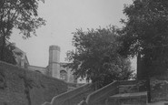
The diocese was founded here in 909 AD, and the present church replaced a Norman one consecrated in 1148.

One hundred years before this, there were no large shops in the town, and the age of the department store was still a few years away.

In 1800, Aberaeron was little more than a farm and inn by the main coast road where a bridge crossed the Aeron.

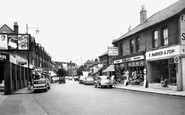
We are looking south-east along Neston's main shopping street, with the wall of St Mary and St Helen's church on the immediate right.

East of the town and the Abbey, Glastonbury Tor rises abruptly to 525 feet above sea level from the 'island' above the Moors on which Glastonbury is built.

This interesting mining village, almost a town, developed in the 19th century close to the great copper mines of Consolidated and United Downs.

The town centre is dominated by its very large triangular market place, which in its turn is visually overwhelmed by the mighty church steeple, completed in 1460 and universally known as the Boston Stump

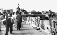
Using water ballast to operate it, it still works today, making the journey between town and beach a much easier one. The pier opened in 1869, and was originally 1500ft long.

One hundred years before this, there were no large shops in the town, and the age of the department store was still a few years away.

There are overgrown sandpits above the junction of Victoria Road (centre left), and Beach Road (centre) which has since been re-named Shore Road.

The photographer looks across the cricket field towards Steine Road (that name again) with the old town and the dominating church of St Leonard to the left.

The photographer looks across the cricket field towards Steine Road (that name again) with the old town and the dominating church of St Leonard to the left.

Once the port for Canterbury, Fordwich was a town when Domesday was compiled. Now it is now just an attractive riverside village.

Its appearance was much the same in a town guide of 1961, when it was advertised as having central heating with fires in all rooms.

Following the death of the owner, the site was acquired by the town and first opened to the public in 1960.

The success of Wisbech has always depended on its rivers and canals. The five mile-long Wisbech Canal once connected the villages of Outwell and Upwell with the River Nene at Wisbech.

Here we see an attractive group of sub-Arts and Crafts buildings with steeply-pitched roofs and tile-hung dormer windows over an open timber balcony.

Looking beyond the medieval parish church the building on the hill behind is the Georgian rectory built in the 1730s by the Rev Benjamin Robertshaw, overlooking the town and away from its bustle
 1907, Honiton")
Honiton's lace production was at its peak during and in the years after the reign of Elizabeth I. It seems to have declined after a series of devastating town fires in the 18th century.

Lewes, the medieval guardian of the gap through the South Downs cut by the River Ouse, occupies a fine hilltop site which produces a superb townscape.

The church stands on the site of an important regional Roman town known as Calleva Atrebatum.
Places (26)
Photos (23)
Memories (3720)
Books (3)
Maps (195)

