Merry Christmas & Happy New Year!
Christmas Deliveries: If you placed an order on or before midday on Friday 19th December for Christmas delivery it was despatched before the Royal Mail or Parcel Force deadline and therefore should be received in time for Christmas. Orders placed after midday on Friday 19th December will be delivered in the New Year.
Please Note: Our offices and factory are now closed until Monday 5th January when we will be pleased to deal with any queries that have arisen during the holiday period.
During the holiday our Gift Cards may still be ordered for any last minute orders and will be sent automatically by email direct to your recipient - see here: Gift Cards
Places
36 places found.
Those places high-lighted have photos. All locations may have maps, books and memories.
- Cardiff, South Glamorgan
- Barry, South Glamorgan
- Penarth, South Glamorgan
- Rhoose, South Glamorgan
- St Athan, South Glamorgan
- Cowbridge, South Glamorgan
- South Molton, Devon
- Llantwit Major, South Glamorgan
- Chipping Sodbury, Avon
- South Chingford, Greater London
- South Shields, Tyne and Wear
- Ayr, Strathclyde
- St Donat's, South Glamorgan
- Llanblethian, South Glamorgan
- Thornbury, Avon
- Llandough, South Glamorgan
- Fonmon, South Glamorgan
- St Nicholas, South Glamorgan
- Jarrow, Tyne and Wear
- Penmark, South Glamorgan
- Font-y-gary, South Glamorgan
- Maybole, Strathclyde
- Yate, Avon
- Oxford, Oxfordshire
- Torquay, Devon
- Newquay, Cornwall
- Salisbury, Wiltshire
- Bournemouth, Dorset
- St Ives, Cornwall
- Falmouth, Cornwall
- Guildford, Surrey
- Bath, Avon
- Looe, Cornwall
- Reigate, Surrey
- Minehead, Somerset
- Bude, Cornwall
Photos
5,054 photos found. Showing results 1,501 to 1,520.


Maps
2,499 maps found.


Books
1 books found. Showing results 1,801 to 1.
Memories
1,580 memories found. Showing results 751 to 760.
Lived On Gas Street
We lived on Gas Street. My family name was Gilder and my parents names were Leonard and Olga nee Carless. My cousins Pamela (nee Gilder) and Gerry Lees still own the Gilders Fishing Tackle Shop in Failsworth. I remember ...Read more
A memory of Failsworth in 1957 by
56 Victoria Terrace
My mum, Esther Scott, lived at the above address and remembers; Jean Gardner, Anne French, Jack, Audray, Ronald & Colin Ripley. Ronald & Colin are on one of her wedding photos! She moved to South Yorkshire ...Read more
A memory of Victoria Garesfield by
Barrage Balloon
Does anyone in the Sheriff Hill area remember, or know of, a barrage balloon breaking loose and doing some damage at St John's Church? My grand-parents are buried there, and as a choir boy I remember their gravestone, which ...Read more
A memory of Sheriff Hill in 1942 by
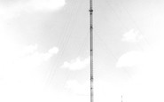
Afternoon Drive To Visit The Mast And Enjoy The View.
Not too sure of the year; visiting my grandad and granny Haywood who lived up South Lane. As a child it was an adventure to go out in grandad's Morris Minor, it had a nodding dog in the back ...Read more
A memory of Holmfirth in 1974 by
Arnherst House
In the 1911 census my great grandparents lived in this house - Arnherst House. John & Alice Upstone; John was a postman. Their son, John Alfred, married Lilian Blackstone Adams (from Foest Row). Then they moved to London ...Read more
A memory of East Grinstead in 1910 by
Orange The Tailors/Pawn Shop In Frederick St. South Shields
Can anybody remember my grandad's shop in Frederick Street? Does anyone have any information about him, his family or his shop? I am trying to research my father's side of the family tree and only have a limited knowledge.
A memory of South Shields in 1940 by
Childhood Days
My family moved from Portsmouth to my father's home town of Hebburn in the mid sixties, we lived at No.47 Byron Ave and I have many happy memories of my life in Hebburn. Sadly, my father died in 1968 and my mother and I moved back ...Read more
A memory of Hebburn in 1968 by
Mishaps In South Croydon
The pub in the middle distance on the right is The Red Deer. On the triangle, which is formed by the junction of Brighton Road & Sanderstead Road, where incidentally I later lived & two of my children were born, ...Read more
A memory of Croydon in 1959 by
At School In Tidworth Bulford And Tidworth Down.
We came back to Tidworth in 1944 from South Africa where we had been evacuated to from Egypt via Palestine in 1940. Father had been repatriated from Stalag VIIIB and was posted to BMH ...Read more
A memory of North Tidworth in 1944 by
Illingworth Remembered
I lived in Keighley Drive, opposite Crossleys sportsfield until I got married and moved to Bradford with my husband. I have so many lovely memories of Illingworth and Ovenden. My brother went to St. Thomas More school and I ...Read more
A memory of Halifax in 1965 by
Captions
2,444 captions found. Showing results 1,801 to 1,824.

In the picture we can see a bus stop sign on a concrete post, for Southdown route 106 only, Worthing to South Ferring.

The south face was undergoing repair work at this time. Pollution, mainly from the smoke from the railways, did a lot of damage to both glass and stone.

The apparent terracing between the river and the church is actually hedges on either side of the Marks Tey to Sudbury railway line and of the road from Bures to Sudbury running south to north across

bypasses Fleckney on its eastern side; the photograph looks north east across Second Lock, towards Kibworth bridge and Bridge House, as the waterway winds towards Newton Harcourt and South

The old Beach Hotel seen here gave visitors good views south across The Green to the Promenade and the coastal shipping coming in and out of the harbour to the west.

The library needed funds, so Sketchley approached the South Kensington Museum and persuaded them to lend various bits and pieces for an exhibition.

Situated to the south-east of the town on the left bank of the river Teith at its junction with the Ardoch, Doune Castle derives its name from the Gaelic word 'dun', meaning a fortified place.

In this view, looking north-east from the bridge on the south bank of the Ouse, the Swan Hotel is seen without ivy.

Three miles south of Sandy we reach Biggleswade, now by- passed by the A1.

Being on a headland, there are two shores here - north and south. Along the latter runs the wide Esplanade, with extensive views across the Bristol Channel.

This 15th-century gatehouse is in the village of Kingswood, one mile south of Wotton; it is part of the Cistercian abbey which existed here until the Dissolution.

The chimneystacks of Lord Burghley's Hospital are an eye-catching feature along the south bank of the Welland.

Situated 4.5 miles south of Birmingham, Bournville was chosen by George Cadbury in 1879 as the site for his new factory and for a model village for his workers.

To the south-west of the town stands the ruined Dilston Hall, home of the Earls of Derwentwater, the last of whom was executed for his role in the Jacobite rebellion of 1715.

Watling Street, three miles south-west of Gravesend. It gained its name from a river passage that once reached it from the Thames at Northfleet.

100 acres was considered enough for a park, and the rest was made available for what was to become Park Road with North and South Parades.

The Palace is situated upon the south shore of Linlithgow Loch. King David I built the first manor house at Linlithgow, and the church of St Michael next to it.

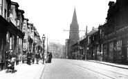
In this view, the market place is mostly a car park, with market stalls along the south side of the Square - one is visible at the left.

The fishing village of Robin Hood's Bay lies just a few miles to the south of Whitby. Also known as Bay Town, the village became a favourite haunt for artists and holidaymakers alike.

It was the country seat of the Duke of Leeds, who lived at Kiveton Park in south Yorkshire. Down by the beck is the 17th-century corn mill, once owned by the Neville family of Middleham Castle.

The parish church is on Horebeech Lane, a turning a little to the south of the shops in view H329029 (on pages 64-65), and dates from the decade after the railway arrived.

This view looks south-west down Loxwood Road towards the parish church, whose spire can just be seen amid the trees behind the last chimney-stack.

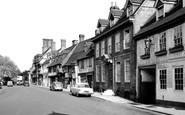
This view looks south. The High Street runs from the parish church, with its white-painted weatherboarded tower, to the Guildford road in the distance.

Nork is a suburb that merges south into Burgh Heath in the large triangle between Reigate Road, Brighton Road and Fir Tree Road, the north boundary of Nork.
Places (15471)
Photos (5054)
Memories (1580)
Books (1)
Maps (2499)

