Merry Christmas & Happy New Year!
Christmas Deliveries: If you placed an order on or before midday on Friday 19th December for Christmas delivery it was despatched before the Royal Mail or Parcel Force deadline and therefore should be received in time for Christmas. Orders placed after midday on Friday 19th December will be delivered in the New Year.
Please Note: Our offices and factory are now closed until Monday 5th January when we will be pleased to deal with any queries that have arisen during the holiday period.
During the holiday our Gift Cards may still be ordered for any last minute orders and will be sent automatically by email direct to your recipient - see here: Gift Cards
Places
36 places found.
Those places high-lighted have photos. All locations may have maps, books and memories.
- Cardiff, South Glamorgan
- Barry, South Glamorgan
- Penarth, South Glamorgan
- Rhoose, South Glamorgan
- St Athan, South Glamorgan
- Cowbridge, South Glamorgan
- South Molton, Devon
- Llantwit Major, South Glamorgan
- Chipping Sodbury, Avon
- South Chingford, Greater London
- South Shields, Tyne and Wear
- Ayr, Strathclyde
- St Donat's, South Glamorgan
- Llanblethian, South Glamorgan
- Thornbury, Avon
- Llandough, South Glamorgan
- Fonmon, South Glamorgan
- St Nicholas, South Glamorgan
- Jarrow, Tyne and Wear
- Penmark, South Glamorgan
- Font-y-gary, South Glamorgan
- Maybole, Strathclyde
- Yate, Avon
- Oxford, Oxfordshire
- Torquay, Devon
- Newquay, Cornwall
- Salisbury, Wiltshire
- Bournemouth, Dorset
- St Ives, Cornwall
- Falmouth, Cornwall
- Guildford, Surrey
- Bath, Avon
- Looe, Cornwall
- Reigate, Surrey
- Minehead, Somerset
- Bude, Cornwall
Photos
5,054 photos found. Showing results 1,681 to 1,700.


Maps
2,499 maps found.


Books
1 books found. Showing results 2,017 to 1.
Memories
1,580 memories found. Showing results 841 to 850.
South Pelaw School
I lived in south pelaw from 1964 until I was married in 1984. We lived in Glencoe Avenue across the road from South Pelaw school which I attended. My first teacher was Mrs Hall and my headmistress was Mrs Young and when she ...Read more
A memory of South Pelaw by
Whittlebury 57 To 61
I have nothing but fond memories of my time at Whittlebury,okay if you were expecting to advance to Oxbridge,forget it but it did teach you to fight your'e own battles and make your own bed.I had a head start I suppose ...Read more
A memory of Whittlebury in 1957 by
Croydon Memories
I was actually born in KCH in the 1960's , but my parents lived in Grange Road, Upper Norwood - and that is where I spent my childhood. Went to All Saints School, Westwood and Lady Edridge Schools. Lessons with the boys from ...Read more
A memory of Addiscombe
Grandmas House
I grew up at my grannys house until age 5. I went to Wingate primary school for a while before we moved south. Her name was Anne Berry and my grandpa James died of cancer. I was born in 1957, and I had 2 little sisters, Pania and ...Read more
A memory of Wingate in 1960 by
Faircross
I was born in Barking Hospital in 1967 but my family moved into Upney House at Faircross in 1953 I believe, this may have been when these were first built. I have lots of memories of Faircross Parade, mostly of the different shops that ...Read more
A memory of Barking in 1979 by
Kingsdown In The 1940's
The picture shown is North Street, where my grandmother & grandfather lived. I always knew the village to be up the hill where some of the shops were. At the end of the houses on the right was the ...Read more
A memory of Kingsdown in 1940 by
Childhood
My Mum, Dad and I moved to the new council houses in Boundaries Road (built on a bombsite) in 1957 when I was 1 year old, so obviously my first memories are of Balham. Dad went to work and Mum and I went shopping every day. These are some ...Read more
A memory of Balham by
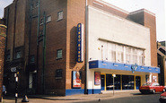
Gillingham Cinema
The Embassy in Green Street was formerly called the Odeon. Other cinemas in Gillingham at that time were the Plaza in Duncan Road (on the site of what is now Aldi's) and the Grand on the corner of Skinner Street and Jeffery ...Read more
A memory of Gillingham in 1950 by
Battersea In The 60's And 70's
Hello, My family originated from east London (mainly Dagenham), but our branch 'emigrated to Battersea in 1964. Our first address was 22 Morella Road, right opposite Wandsworth common. I went to Honeywell junior ...Read more
A memory of Battersea in 1970 by
Cherwell Grove/ Stifford Road
These houses are in Cherwell Grove, South Ockendon. The one on the right hand side of the semi with the white door and garage door was the doctor's surgery at some time during the 1960s.
A memory of Aveley in 1960
Captions
2,444 captions found. Showing results 2,017 to 2,040.

From Newstead Abbey the route heads four miles south to Hucknall, which also has Byronic associations: in this church Byron was buried in the family vault after his body had been brought home from Greece

South-east of the town, along the valley of the River Ise and west of Barton Seagrave village, is The Wicksteed Park with the river dammed to form a large lake as the centrepiece.

We are just below the South Downs on the road between Midhurst and Chichester; this view looks across a footbridge over the stream that feeds into the Rother near Midhurst.

This classic view of England's largest lake was taken from the south end of Loughrigg. Ambleside town is round the corner to the left.

Here the photographer looks north-west from near the hillfort that occupies the crest of the ridge, towards Poynings village and the scarp of the South Downs beyond at North Hill and Newtimber Hill.

On the south side of the street are several half-timbered houses of notable quality, with Shakespeare House and its prominent gable, and the Chequers Inn, both very evident.

By the end of the 18th century it had become the principal coal port in south Wales; all this from what half a century before had been little more than a few wharves.

The road sign points down South Street which is almost invisible between the public building and the shops. Colmer`s Hill (right of centre) forms the distant skyline.

limestone crag overlooking the Towy Valley, the present Carreg Cennen dates from the late 13th century, though the site has historical links with the ancient commote of Is-Cennen, and sections of the south

The church itself has a Norman south aisle and sits in a delightful churchyard with the backs of timber-framed cottages on one side and the Misbourne in its valley on the other.

To the south-east of mediaeval Finchley, the High Road drops down from the North Circular Road between an almost standard series of parade shops built around the turn of the century, and past the Rex Cinema

Further along the south side of the street (left of centre) is the Old Inn. West Court is behind the hand-cart.

This, the south gate to the castle keep, is today the main entrance, but it is thought that in the castle's heyday the north gate was the main access.

The parkland of 18th-century Welton Place sweeps south to the north bank of the Grand Union Canal, in its cutting leading to the east portal of the Braunston Tunnel.
building swept ever outwards, mainly to the north and east of the city centre, the 'scarlet fever' of private red-brick detached and semi-detached houses and bungalows filled the southern, south-western

The photograph looks south-east along the culverted stream bordering Station Road, with housing of the 1920s and 30s on the extreme right.

There are two prominent buildings of quality in the village, firstly the 13th-century parish church of St Peter and St Paul, and Langham Old Hall with its date stone of 1665 built into the south

Internally, the church has a good late 12th-century north arcade and a later south arcade. The great Gothic Revival architect George Edmund Street (1824-81) restored the building in 1852 and 1861.

This took development as far east as the old main road which had turned south to Walton, now marked by King Edward's Avenue.

This discreet little settlement in the parish of Stanton St Gabriel occupies a web of small lanes on the south-facing slopes of Hardown Hill and derives its name from three Old English words: 'mor' (

From the south-east, a look at the Institute, which has now sprouted a clock, put up in 1891 in memory of Thomas Cramp, the town's diarist and total abstainer.

Inside, the 14th-century north aisle has octagonal granite piers, while the 15th-century south aisle has piers of Polyphant stone with carved capitals.

The old Tudor timber-framed cottage formerly stood slightly further to the south, before being purchased by Epsom Rural Council in 1922 when it was dismantled and transferred to this present site.

Slyne, with Hest, also near Lancaster, saw Bonnie Prince Charlie's 1845 army of Scots passing on their way south.
Places (15471)
Photos (5054)
Memories (1580)
Books (1)
Maps (2499)

