Places
Sorry, no places were found that related to your search.
Photos
134 photos found. Showing results 661 to 134.
Maps
896 maps found.


Books
3 books found. Showing results 793 to 3.
Memories
540 memories found. Showing results 331 to 340.
Peel Street School
My grandmother and her brothers and sisters attended this school as did my mother and moi. I have many memories of the school. Endless games of football in the yard, rain or shine. Two frightening headmistress Lord and Riley. ...Read more
A memory of Cloughfold by
Peeping Around The Curtain
Every year we set off from York for a two week holiday at Thornwick Bay. We used to travel by bus, and I well remember the bus always used to breakdown at the top of Garrowby Hill. Everyone had to get off the bus ...Read more
A memory of Thornwick Bay in 1956 by
Personal Reflections
I was born in Sandleaze, Worton in 1957. I was brought up at 1 Mill Road near the Marston boundary. I remember many things about the village especially the Rose and Crown Pub and the Mill. I remember with pride the ...Read more
A memory of Worton by
Petrol Pump
In 1955, aged 12 years old, I clearly remember visiting North Devon with my father - we toured the district traveling on an old two stroke Francis Barnet - we stayed bed and breakfasting with 'Percy' who lived close to Woody Bay - My ...Read more
A memory of Kentisbury Ford by
Photo Location
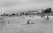
This picture shows the beach and the Eastern Esplanade at the Thorpe Hall Boulevard Junction. The elaborate shelter was built as the Thorpe Bay Terminus Waiting Room for the Southend Corporation Tramways before the Esplanade Line was linked ...Read more
A memory of Thorpe Bay by
Playhillocks Cottage
My sister and I were born in Playhillocks Cottage, Longhaven - me in 1937 and my sister in 1936. When I was about 3 or 4 we moved to a council house in Cruden Bay, Serald Street, where my brother was born. In 1950 we migrated ...Read more
A memory of Longhaven in 1930 by
Plympton In The Blitz
My name is Robert Best. I was born June 24th. 1939 in Plymouth and evacuated to Princetown in 1941. My Mother, her parents and I moved to Plympton when I was 3 years old. I have clear memories of Princetown, of riding the train ...Read more
A memory of Plympton by
Plympton In The Blitz
My name is Robert Best. I was born June 24th. 1939 in Plymouth and evacuated to Princetown in 1941. My Mother, her parents and I moved to Plympton when I was 3 years old. I have clear memories of Princetown, of riding the train ...Read more
A memory of Plympton by
Port Quin
As a young man with my first car and girlfriend we toured Cornwall and came across Port Quin, wow what a place. No one came here, most of the houses were derelict, the small car park to the left was the only place to park about six ...Read more
A memory of Port Quin in 1969
Port Regis
I remember Port Regis very well, I stayed there as a child. It was a convalescent home then for girls. The nuns used to take us down to the beach every Wednesday afternoon - Kingsgate beach that is. Though it is 40-some odd years ago ...Read more
A memory of Broadstairs in 1956 by
Captions
870 captions found. Showing results 793 to 816.

The bay marks the natural harbour of this spot.

Below, a shingle beach with patches of pea-grit provides a spot for rest and relaxation between Raffey's Ledge and the Mouth Rocks, where the River Char enters the sea.

Lancaster's beautiful canal, with its magnificent sea views of Morecambe Bay, was originally the vision of the factory owners of the locality, who were eager to connect their mills with the national canal

This view looks north along Woodcote Road towards the railway bridge. The station is on the left, but is concealed by the distant shops.

Much of this corner of the Market Place has changed since this photograph was taken.

Bridlington lies near the top of Bridlington Bay, its northern flank protected by the great headland of Flamborough some six miles distant.

Gregory Gregory, a bachelor, was probably responsible for as much of the design as his architects, Anthony Salvin and later William Burn, as it rose slowly throughout the 1830s and 1840s.

A solid little stone tower on a slant, nothing elaborate, dates from the 13th century and is on the north side of the church, not at the usual west end. The church has Norman origins.

The lifeline between Poole and Purbeck, crossing between Sandbanks (right) and Shell Bay (left), is the Floating Bridge.

Donkeys are awaiting the arrival of the day's holidaymakers on the beach. A fisherwoman in a tall hat stands behind the donkey boys and their mounts.

There is evidence that the earliest bricks in Fareham come from Portchester Castle.

South Luffenham on the river Thater is a 7th-century Saxon settlement with North Luffenham, now adjacent to the A6121 Uppingham to Stamford road to the north, an attractive village of narrow streets and

When they see it from the road or the nearby railway, travellers are puzzled by this church with towers at both ends.

Aberdour in the Kingdom of Fife, lies between Burntisland and Dalgety Bay, just across the Firth of Forth from Edinburgh.

We are looking eastwards along gated Ware Lane (centre) to Golden Cap (skyline, centre right) and Lyme Bay (right).

Tenby was described thus in a Victorian guidebook of 1895: 'Tenby stands on a tongue of limestone rock, ending in a green promontory, which is crowned by the ruins of the old castle, and is now pleasantly
Tenby was described thus in a Victorian guidebook of 1895: 'Tenby stands on a tongue of limestone rock, ending in a green promontory, which is crowned by the ruins of the old castle, and is now pleasantly

Catterick has three greens; this one looks along Sour Beck to the 15th-century parish church of St Anne, financed by the owners of nearby Brough Hall.

North of Fir Tree Road and just beyond Banstead railway station is Cuddington Park Golf Course; the name is a reminder of the parish and village of Cuddington, which was cleared for Henry VIII's Nonsuch

Lindale is close to the River Winster, the old Lancashire and Westmorland border. John Wilkinson, the ironmaster, is buried in the churchyard in an unmarked grave; it was his fifth burial.

This is another view of Lower Eype from further to the south-west, closer to the cliff above Lyme Bay, looking inland to Mount Lane and St Peter`s Church (centre).
This is another view of Lower Eype from further to the south-west, closer to the cliff above Lyme Bay, looking inland to Mount Lane and St Peter's Church (centre).

Seaside bustle on the promenade, built as the old Upper Walk between the town and the Cobb Harbour in 1817; it is now known as Marine Parade.

The Royal Arms of James I above a ground-floor fireplace may indicate its continuing official use into the 17th century.
Places (0)
Photos (134)
Memories (540)
Books (3)
Maps (896)

