

Merry Christmas & Happy New Year!
Christmas Deliveries: If you placed an order on or before midday on Friday 19th December for Christmas delivery it was despatched before the Royal Mail or Parcel Force deadline and therefore should be received in time for Christmas. Orders placed after midday on Friday 19th December will be delivered in the New Year.
Please Note: Our offices and factory are now closed until Monday 5th January when we will be pleased to deal with any queries that have arisen during the holiday period.
During the holiday our Gift Cards may still be ordered for any last minute orders and will be sent automatically by email direct to your recipient - see here: Gift Cards
Places
36 places found.
Those places high-lighted have photos. All locations may have maps, books and memories.
- North Walsham, Norfolk
- North Berwick, Lothian
- North Chingford, Greater London
- Harrogate, Yorkshire
- Whitby, Yorkshire
- Filey, Yorkshire
- Knaresborough, Yorkshire
- Scarborough, Yorkshire
- Clevedon, Avon
- Weston-super-Mare, Avon
- Richmond, Yorkshire
- Selby, Yorkshire
- Ripon, Yorkshire
- Scunthorpe, Humberside
- Pickering, Yorkshire
- Settle, Yorkshire
- Skipton, Yorkshire
- Saltburn-By-The-Sea, Cleveland
- Norton-on-Derwent, Yorkshire
- Rhyl, Clwyd
- Chester, Cheshire
- Llandudno, Clwyd
- Grimsby, Humberside
- Durham, Durham
- Nailsea, Avon
- Southport, Merseyside
- Brigg, Humberside
- Colwyn Bay, Clwyd
- Redcar, Cleveland
- Bath, Avon
- Grange-Over-Sands, Cumbria
- Cleethorpes, Humberside
- Sedbergh, Cumbria
- Barrow-In-Furness, Cumbria
- Barmouth, Gwynedd
- Dolgellau, Gwynedd
Photos
2,953 photos found. Showing results 741 to 760.


Maps
9,439 maps found.


Books
39 books found. Showing results 889 to 912.
Memories
1,550 memories found. Showing results 371 to 380.
Hatch End High School
In December 1995 the Harrow Arts Cuncil organised a festival of dancing at Hatch End High School and invited a dozen or more dance groups and schools to come along and provide a showcase of talent. It was fascinating to see ...Read more
A memory of Hatch End in 1995 by
North Bovey School
I went to the school and lived in a home in Manaton, we went by coach, it seemed miles away. One of the teacher lived in one of the bungalows on the left just before the school. I have now moved to Devon and been back to see the school and the hall next door it was used for indoor games/gym.
A memory of North Bovey in 1959 by
General Memories
My family were the Elstones who lived in High Street on the 1881 census, although they were all in the Burnham area for many years. My grandfather was Manager of Websters Coal Yard at Taplow station, but then returned to the village ...Read more
A memory of Burnham
Son Of Sgt Bruce Krrc
My father was stationed at Chisledon Camp from 1939 to 1942. Living in Littlehampton on the south coast, threatened with invasion, my mother rented the end thatched cottage of the row of cottages which face the railway line ...Read more
A memory of Chiseldon in 1940 by
Rcaf North Luffenham
My father was in the RCAF, stationed at the former RAF base. We lived in the village from 1952 to 1954. The picture on this site was where we lived at the time. The village shop was next door and was operated by Mr and ...Read more
A memory of North Luffenham in 1952 by
Wartime Memories Of Hay Part Two
Memories of Hay during the Second World War: Part Two. (Continued from Part One) Thoughts of 'Dad's Army' remind me that the local Home Guard occasionally used Forest Road for some kind of exercise. I've dim ...Read more
A memory of Hay-on-Wye in 1940 by
Paignton Was My Crucible 1947
My mother gave life to me in Paignton hospital (now a hospice I believe) in July of this year (1947) and I spent much of my early years in and around this lovely little town. Not so lovely or little now but still grand ...Read more
A memory of Paignton in 1947 by
Captions
2,676 captions found. Showing results 889 to 912.

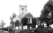
While the church was largely rebuilt in the 1840s, the arcade and north aisle roof are 16th-century.

The crossroads at Milnthorpe was well known to motorists travelling to Scotland or the Lake District on the A6 before the advent of the M6 motorway.

The clerestory was added in the 17th century and the north aisle remodelled in the 1870s.

Great Wakering is an attractive village, just a few miles to the north of Shoeburyness in the remote old marshlands of the south east of Essex.

This is the Steeping river flowing towards the Wash and the North Sea. Earlier in its life it had more publicity, as it is also known as Tennyson's brook.

North-east of Cambridge, the River Cam quickly becomes wooded on either side, setting an attractive scene here at Baits Bite Lock.

The London and South Western Railway built their Exeter to Plymouth line to the north of Dartmoor through Okehampton.

Castle Street runs north from the town centre. Two boys are using the drainage dyke to sail their toy yacht. The town was once a significant cloth-producing centre, renowned for its kersey.

Another of Oxford's much-loved landmarks is the Hertford College Bridge, or the Bridge of Sighs as it is otherwise known.
North-east of Cambridge, the River Cam quickly becomes wooded on either side, setting an attractive scene here at Baits Bite Lock.

At the junction with Paternoster Row, Cheapside swings from the north in an arc and heads east towards the Bank.

This 15th-century slate-hung house is on the North Quay and was once the Guild House of Padstow's merchants.

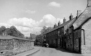
The King's Head still stands beside the road, which drops north from the village to the moors below. A cottage on the left was once home to the blacksmith; his forge stood beyond the pub.

Here we see the main road leading north from Preston and the Methodist Church.

Inland from Filey and Bridlington, this village contains a pond just behind the church of St Cuthbert, which is a chapel of ease for the mother church of All Saints at Hunmanby.

We are looking from North Street into Larmer Street. The large Methodist church dates from 1797, and was greatly expanded in 1831.

There are some interesting friezes over both the south and north porches. Outside the east window are the arms of William of Wykeham, founder of Oxford's New College.

The church is that of St Andrew, which lies on the western edge of a steep-sided valley, two miles north of Presteigne.

This is Mowbray Park, created in the 1850s out of Bildon Hill and the old quarries on its north face.

This view looks north down the lane to Lower Limpley Stoke, with the railway curving along to the station beyond the locomotive water tower (now closed).

Harcombe runs roughly parallel to Yawl; it is another long combe running north from the main valley of the River Lim.

The north breakwater which enclosed the outer harbour in the 1890s also serves as a promenade for visitors.

The ribbon development along the line of Godstone Road is well illustrated here, looking north towards Riddlesdown chalkpit.

North Stoneham Church was rebuilt at the end of the 16th century in the Gothic style.
Places (9301)
Photos (2953)
Memories (1550)
Books (39)
Maps (9439)

