Merry Christmas & Happy New Year!
Christmas Deliveries: If you placed an order on or before midday on Friday 19th December for Christmas delivery it was despatched before the Royal Mail or Parcel Force deadline and therefore should be received in time for Christmas. Orders placed after midday on Friday 19th December will be delivered in the New Year.
Please Note: Our offices and factory are now closed until Monday 5th January when we will be pleased to deal with any queries that have arisen during the holiday period.
During the holiday our Gift Cards may still be ordered for any last minute orders and will be sent automatically by email direct to your recipient - see here: Gift Cards
Places
26 places found.
Those places high-lighted have photos. All locations may have maps, books and memories.
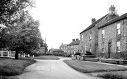
- Town End, Derbyshire
- Town End, Buckinghamshire
- Town's End, Somerset
- Towns End, Dorset
- Town End, Merseyside
- Town End, Cambridgeshire
- Town's End, Buckinghamshire
- West End Town, Northumberland
- Bolton Town End, Lancashire
- Kearby Town End, Yorkshire
- Town End, Cumbria (near Grange-Over-Sands)
- Town End, Cumbria (near Bowness-On-Windermere)
- Town End, Yorkshire (near Huddersfield)
- Town End, Yorkshire (near Wilberfoss)
- Town End, Cumbria (near Appleby-in-Westmorland)
- Town's End, Dorset (near Melbury Osmond)
- Town's End, Dorset (near Swanage)
- Town End, Cumbria (near Ambleside)
- Town End, Cumbria (near Lakeside)
- Town End, Cumbria (near Kirkby Lonsdale)
- Town End, Cumbria (near Ambleside)
- Town's End, Dorset (near Bere Regis)
- West-end Town, South Glamorgan
- Townend, Derbyshire
- Townend, Strathclyde (near Dumbarton)
- Townend, Staffordshire (near Stone)
Photos
26 photos found. Showing results 201 to 26.
Maps
195 maps found.
Books
160 books found. Showing results 241 to 264.
Memories
3,720 memories found. Showing results 101 to 110.
Theres No Place Like Home
I used to walk up Railway St years ago on my way home to Pilgrim St. Looking at these street pictures makes me want visit and see my old home town. I went to Walverden School but can't remember the name of the street it ...Read more
A memory of Nelson in 1946 by
Happy Days In Newquay
My parents were friends of the Lukes and as my father was in the war, and Birmingham was getting more bombing, it was decided to send me down to auntie Dorothy. I enjoyed down there, although I was only 4yrs old I still ...Read more
A memory of Newquay in 1943 by
Lowestoft, High Lighthouse 1921
I really love this lovely old photo. It shows a WW1 British tank which was used in the first world war in France, it was given to the town after the war had ended as a gift. It was stored there for many years until it was scrapped, it fell into poor condtion, as school children used to play on it.
A memory of Lowestoft by
Isaac Green 1800's
Alas, I have no memories of Camerton. I have never visited this town of my ancestors. I have been to Bath, but at the time never knew of the existence of my family having originated in Camerton. My ...Read more
A memory of Camerton by
Tottenham Lane Post Office
I worked as a telegram messenger at the post office in Tottenham Lane. We delivered telegrams on 250cc BSA motorcycles which covered Highgate Village. We used to go to the British Restuarant opposite Rokerly School ...Read more
A memory of Hornsey in 1945 by
Years Gone By From 1944 To Present Time
Hi, my name is Dot Dunn (nee Harmer). I've lived in Station Town and Wingate all my life and wouldn't want to live anywhere else and am still in contact with a lot of my school friends. I can still name ...Read more
A memory of Wingate in 1950 by
Memories Of The 60 70's
Lived here in the 60's, went to school at Pocklibgton, and eventually ended up working at Cooke Throughton & Simms in York. Can remember some of the names, and now have lived in Cape Town for the past 40 years.
A memory of Wilberfoss by
31 King Street
Worked at J P Jacksons Butchers as a messenger boy. Good old days, great town and still is.
A memory of Ulverston in 1961 by
51 Hempstead Street
I was born in Dover, but my mum was Welsh and we moved back to her home town when I was small. However, every year we would visit my dad's relatives in Kent (mainly Ashford). My Auntie Nell ran a flower shop here and I remember ...Read more
A memory of Ashford in 1955
The Halcyon 1950's
I lived with my family in Connaught Gardens from being born in 1949 to late 1960 when we moved to Shiremoor. At the end of our street was an overgrown, rubble strewn wasteland which we called 'The Croft'. A natural childrens ...Read more
A memory of Forest Hall in 1950 by
Captions
5,111 captions found. Showing results 241 to 264.

North of Wainfleet, on the Skegness to Lincoln road, Burgh le Marsh is a market town whose charter was granted in 1401. At its east end is another of Lincolnshire's preserved windmills.

This view looks east from Cornwall Road along Worcester Road towards the town centre. This was another desirable residential road, with prosperous Victorian villas at its eastern end.

The house with the two dormers is Lawrence House, now the town museum, and at the far end we can see the gable of Eagle House.
The house with the two dormers is Lawrence House, now the town museum, and at the far end we can see the gable of Eagle House.

Horses tread the tramway along Pwllheli's busy promenade at Marian-y-mor (then known as West End). The tramway had opened two years earlier, in 1896, and was closed in 1927.

Lumley Avenue, with its chestnut trees and wide verges and roadway, is typical of the streets comprising the original grid layout of the Earl of Scarbrough's 1870s town plan.

Its grandeur also reflects the flourishing wool trade in the town at this period.
Horses tread the tramway along Pwllheli's busy promenade at Marian-y-mor (then known as West End). The tramway had opened two years earlier, in 1896, and was closed in 1927.

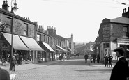
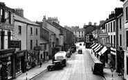
Dale Street is one of Liverpool's original seven streets, and is captured here full of hustle and bustle. The Municipal Building, with its tower and clock face, stands out further up the street.

Across the road James Barlow, 'family grocer and provision merchant,' had the biggest food shop in the town; from the open doorway an appetising smell of ground coffee drifted into the street.

One of the oldest surviving fragments in the town, this 12th-century arch now forms the entrance to St Mary's Passage, a narrow path running down towards the meadows.

For centuries, the repair of bridges and maintenance of roads was the responsibility of the parishes in which they were situated, though important crossing points were often maintained through a levy raised

The Canongate was where the canons of Holyrood Abbey entered the Old Town. The tolbooth, with its projecting clock, is one of the most famous landmarks on the Royal Mile and dates from 1591.

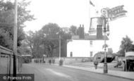
The 17th-century Angel Inn stands at the east end of Middle Street and the start of Main Street, and is one of a number of interesting buildings around the area.
The house with the two dormers is Lawrence House, now the town museum, and at the far end we can see the gable of Eagle House.

This £40,000 concert and dancing hall opened in 1903; the plans were by R J Beale and the noted theatre designer Frank Matcham.

The lower end of West Street, looking westwards, has all manner of public houses from the Sun Hotel (left) to the Lily Hotel. Between them are the showrooms of Bridport Motors.

A street cleaner works below the church wall, while a boy seems interested in William Box's grocery, wine and spirit shop; two ladies approach Russell and Co's drapery shop next door.

By 1905 a spurt of building would fill in the right-hand side all of the way into town.
The lower end of West Street, looking westwards, has all manner of public houses from the Sun Hotel (left) to the Lily Hotel. Between them are the showrooms of Bridport Motors.

We look north-eastwards, above the gable-end of the Bay Private Hotel (centre right), to the Spittles and Black Ven. Beyond are Charmouth and Stonebarrow Hill (top right).

Towards the end of the 19th century it was decided that the town needed a town hall commensurate with its new affluent status.

This is East Bridge, at the eastern end of East Street (far right), looking eastwards from the north bank of the River Asker.

This is all that remains of the magnificent west front of the Abbey, now reduced in height and stripped of its facing stone.
Places (26)
Photos (26)
Memories (3720)
Books (160)
Maps (195)

