Places
26 places found.
Those places high-lighted have photos. All locations may have maps, books and memories.
- Cemmaes Road, Powys
- Six Road Ends, County Down
- Road Weedon, Northamptonshire
- Severn Road Bridge, Gloucestershire
- Roade, Northamptonshire
- Berkeley Road, Gloucestershire
- Harling Road, Norfolk
- Road Green, Devon
- Builth Road, Powys
- Cross Roads, Yorkshire
- Steele Road, Borders
- Cross Roads, Devon
- Four Roads, Dyfed
- Road Green, Norfolk
- Biggar Road, Strathclyde
- Clarbeston Road, Dyfed
- Five Roads, Dyfed
- Eccles Road, Norfolk
- Grampound Road, Cornwall
- Morchard Road, Devon
- Wood Road, Greater Manchester
- Four Roads, Isle of Man
- St Columb Road, Cornwall
- Clipiau, Gwynedd (near Cemmaes Road)
- New Road Side, Yorkshire (near Silsden)
- New Road Side, Yorkshire (near Cleckheaton)
Photos
14,329 photos found. Showing results 1,701 to 1,720.


Maps
476 maps found.
Books
5 books found. Showing results 2,041 to 5.
Memories
11,058 memories found. Showing results 851 to 860.
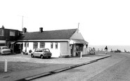
"The Cafe"
A familiar landmark for anybody who knows Overstrand. This picture could have been taken from my old front garden down Cliff Road. When I first became interested in cricket (1964-5 ish) around the age of 9 or 10, I would be watching ...Read more
A memory of Overstrand by
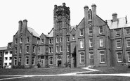
I Remeber Hutton Residential School
I was a 'student' at the institution from about 1948 to 1953. I remember some of the staff. Head master was Mr Higdon, Teacher of wood work and house master was Mr McFadon. there was Gov Reily, Mr & ...Read more
A memory of Shenfield in 1953 by
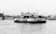
Woolwich Ferry
There has been a ferry at Woolwich for many centuries but the people of Woolwich complained in the 1880s that West London had free access across the River Thames by bridges so why couldn't they have free travel? The river was too ...Read more
A memory of Woolwich by
Living In Eccles
I remember when I lived in Pembroke Avenue, as a youngest but before that we lived in Crambrooke Road, Einton, then in 1967 on St Patrick's Day we left to emigrate to Australia, I have not returned there since then but still have ...Read more
A memory of Eccles in 1967 by
Portwrinkle Beach
My parents used to take me there after school sometimes on their half day off from Menheniot C0-Op in the 1950s and early 1960s when I was a child. It was a steep climb down to the beach from the road but worth the effort. ...Read more
A memory of Portwrinkle by
Where I Was Born
My Beginning, at Sole Street near Cobham Kent. (9th March 1946 - 2nd January 1951) I was born on Saturday March 9th 1946 at 3.29pm at Temperley, The Street, Sole Street, Kent. I was delivered at home by the ...Read more
A memory of Sole Street in 1946
Heswall Shore
My nanny and gampi lived on Banks Road in the 1960s. Nanny (Tilly Wilson) used to shell the shrimps in her kitchen. We would pay them a visit on our way down to Heswall shore and the shrimps would be piled high in the middle of the ...Read more
A memory of Heswall in 1967 by
Abc Minors,Trolley Buses, Lonesome School, Oakleigh Way
I have just found this page and what memories it rekindles. I was a minor at the ABC, I even got a road safety prize from Coco the Clown. Thorpes record shop accross the road, there I bought my ...Read more
A memory of Mitcham in 1955 by
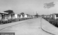
My Place Of Birth
I was born in one of those prefabs halfway down on the righthand side, number twenty three in fact. My mum and dad must have thought they`d gone to heaven, moving from a blitzed east end tenemant with a shared outside ...Read more
A memory of South Ockendon by
Raddlebarne Road
1978 was the date I left Sellyoak to live in Wales. I have a lot of fond memories. I was born at 132 Raddlebarne Road in 1965. My mother was called Sheila, she sadly passed away last year, My grandparent were Edith and Osbert ...Read more
A memory of Selly Oak in 1978 by
Your search returned a large number of results. Please try to refine your search further.
Captions
5,036 captions found. Showing results 2,041 to 2,064.

The road descends to Carter's Brook with Manor Farm on the left. It is interesting that in 1908 the telephone had already reached this remote spot.

The wooden road bridge had to be replaced in 1926: it was rotting, and traffic was becoming heavier.

This road, Lodge Lane, was then the main A13, linking Southend and London. In the foreground is Albert Winn's confectioner's, with its well-stacked window display.

In 1800, Aberaeron was little more than a farm and inn by the main coast road where a bridge crossed the Aeron.

We are looking west towards the cross-roads in the part of Upton known as The Village.

Changed, but still recognisable, The Star and Garter presides over a major road junction constantly busy with traffic.

The new dual carriageway was built all along this length of road, but fortunately all these buildings survive.

It too has since been replaced by a modern road bridge that opened in 1993.

Beside the main road through the village on the base of the ancient cross is an elaborate war memorial.

New in 1772, the road was built to bypass congested town centres from Star Hill, Rochester to the bottom of Chatham Hill.

Road works are in progress outside.

The Grammar School, on Normanby Road, South Bank was opened in 1955.

1960s the photographer must have risen very early to take this picture; although the cars were not yet controlled by lights, even then there was usually much heavier traffic on the main road

The road on the left curves past the houses of Nansladron, where the fields in the valley floor are now caravan and camping parks.

The area known as Park Road Gardens was purchased by Grange Urban District Council from the Rev James Park in 1926.

St Mary's Roman Catholic Church on Burnley Road, Clayton-le-Moors dated back to 1819, and predated all other Roman Catholic churches in the area.

Single-decker buses wait on opposite sides of the road. Note the straight-backed cars, many still with running boards. The church is dedicated to St Mary the Virgin.

The pub which gave this important road junction its name has existed since at least 1765, when it was used for court sittings.

This view of the Wokingham Road entrance is nowadays remarkably unchanged, apart from the loss of the lamps atop the gate piers and of the lodge cupola in the distance.

Leaving the villages along the river, we move inland south to Earley, now very much part of Reading. In 1910 Church Road was a country lane still.

Back to the river and downstream of Reading, Sonning Lock itself has been entirely renewed but the cottages remain.

The M25 now skirts the south of this former market town, and link roads have destroyed some of the town's ancient character and streets.

Located on Newport Road's old Infirmary site its £50,000 set-up cost was partially met by the Marquess of Bute.

Green-painted iron gates inscribed `In memory of the fallen` open into the Garden of Remembrance from Plymouth Road, just round the corner from the bus station.
Places (26)
Photos (14329)
Memories (11058)
Books (5)
Maps (476)

