Places
36 places found.
Those places high-lighted have photos. All locations may have maps, books and memories.
- Yosemite National Park, USA
- Yellowstone National Park, USA
- Gardens of Stone National Park, Australia
- Worcester Park, Greater London
- Langley Park, Durham
- Killerton Park, Devon
- Swinton Park, Yorkshire
- Goodwood Park, Sussex
- New Parks, Leicestershire
- Gidea Park, Essex
- Rokeby Park, Durham
- Hawkstone Park, Shropshire
- Clumber Park, Nottinghamshire
- Gunton Park, Norfolk
- Erddig Country Park, Clwyd
- South Park, Surrey
- Eastwell Park, Kent (near Ashford)
- Highams Park, Greater London
- Raynes Park, Greater London
- Grange Park, Merseyside
- Tong Park, Yorkshire
- Bush Hill Park, Greater London
- Park Street, Hertfordshire
- Grange Park, Greater London
- Wembley Park, Greater London
- Lambton Park, Durham
- Motspur Park, Greater London
- Roundhay Park, Yorkshire
- Grove Park, Greater London (near Eltham)
- Baddow Park, Essex
- Park Gate, Hampshire
- Shillinglee Park, Sussex
- Kiveton Park, Yorkshire (near Wales)
- Park, Somerset
- Park, Wiltshire
- Park, Cornwall
Photos
9,057 photos found. Showing results 1,401 to 1,420.


Maps
1,865 maps found.


Books
1 books found. Showing results 1,681 to 1.
Memories
4,384 memories found. Showing results 701 to 710.
My Years In Tring
I was born at Aylesbury Hospital in 1948 and lived briefly at Pitstone, then Tring in Park Road and later Western Road. My Parents, Grandparents and many other relatives lived in the town. I attended Gravelly infant school in Park ...Read more
A memory of Tring by
Another Sudbury Town Boy
I was born in the High Street( not the High Road) in 1950 moving to Rugby Avenue in 1953. I lived opposite Graham Rose. I recall the Sudbury Motors Garage. They had Morgan 3 wheelers and drove them up and down Rugby Avenue. Happy memories of Barham Park and Vale Farm swimming pool.
A memory of Wembley by
Watching Granddad Play Bowls
I was only a toddler at the time but my Granddad, who I lived with, used to take me to the park when he was going to play bowls with his friends. I used to sit in my pram and take it all in. This was during the war years.
A memory of Normanton
Brierley Hill Girls Memories
I was born in Chapel Street, in 1947. My uncle, Len Gray, had a newsagents in the town, near the bus stop by the Old Post Office, as was. My Grandad used to sell papers on the Five Ways and as a girl I would stand ...Read more
A memory of Brierley Hill
Good Old Battersea
I was born and bred in Battersea, Firstly we lived in Yelverton road with my Grandparents and I attended Falconbrook School. Then my parents got a Maisonette in Culvert road I then attended Chesterton School. in 1969 I attended ...Read more
A memory of Battersea by
War Time At Auldgirth .
I remember Auldgirth fondly,the school the people realy great times.Ilived at hillend farm it was quite a walk to school,The football park was in one of our fields great times.If any one remembers me Iwould likr to hear from them .Jim Johnstone .
A memory of Auldgirth by
Shops On The High Street
I was born in chapel street number 14wich was the back of a shop next to gittens it was owned by mrs price who also lived there at the back of the house my grandmother dolly perry had 2 shops along the high street and a ...Read more
A memory of Brierley Hill by
1955 To 1980
I remember going to the shops in Hounslow High street with my mum and dad. The ABC cafe which had rows of perspex boxes with different cakes and sandwiches in each one. MacFisheries, and a department store which I think was called ...Read more
A memory of Hounslow
Home Sweet Home
At the time this photograph of the High Street was taken I was 15 years old. Not knowing then, I would be walking down this road some years later with my first girlfriend and now my wife of 51 years. Where the ...Read more
A memory of Teddington by
Turnbull Road Off Reddish Lane
I lived in albert avenue off turnbull road from 1944 until 1957. It was a great place to live.We skated on Turnbull road,had a rope round a lamp post as a swing,played on bikes.Went to Debdale park played tennis if ...Read more
A memory of Gorton by
Captions
2,179 captions found. Showing results 1,681 to 1,704.

Traffic lights control the junction with the High Street, and the Hotel now boasts a car park.

The King's Head in The Street in Capel, a village now by-passed by the A24 London to Worthing road, is now a private house, and its once sterile car park is now an attractive front garden

It was in this house on the left of the photograph that Jane Austen wrote 'Mansfield Park', 'Emma' and 'Persuasion'.

It was in this house on the left of the photograph that Jane Austen wrote 'Mansfield Park', 'Emma' and 'Persuasion'.

Today this hill is a wonderful place to walk as it is largely taken over by the Queen's Wood Country Park with an extensive collection of trees from all over the world.

The old Roundhay estate was then opened on 20 September 1872 as the country's first municipal park.

Through the famous Cow and Calf Rocks high up on Ilkley Moor, we can see the estate of Denton Park, once the home of the Fairfax family.

was taken, the roof appears to have fallen into disrepair, and it was only a few more years before the building, along with the cramped terraced housing alongside, was demolished to make way for a car park

Positioned alongside the old course of the Great North Road, the unusual and impressive 'Bottle Lodges' at the entrance to Burghley Park must have been a familiar sight to travellers approaching Stamford

The water in front of the mill has now been covered over and has become a car park. The mill is no longer in use, but has moved into a modern building not far away.

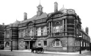
This part of Sunderland developed into the commercial and civic heart of the town following the opening of Fawcett Street Station by the North Eastern Railway.

On the right, the narrow strip of park beyond the trees is the Common Acre, where the archers of Andover practised before going into battle under Henry V at Agincourt in 1415.

Today a visitor centre in the stables tells of Snowdonia National Park's natural history and that of Gwydir Forest.

There is little apart from the Mini van parked in front of the terraced house on the bottom right of the picture to give away the date of this view, which looks north over Abergynolwyn.

The park had only been in public hands a short time when these photographs were taken.

Many motorists hurrying to work would find the bridge swung, and their way into Trafford Park held up, making them late for work.

In 1950 the old market place had become a car park.

Shortly after the outbreak of the First World War in 1914, the War Office commandeered part of the grounds of Woodcote Park for training purposes and erected a large encampment.

The clock turret of Moreton's most prominent building displays the date of its construction as 1887, and on the south wall is the coat of arms of the Redesdale family of Batsford Park who

Not far away are Chelwood Vachery, a re-created hall-house originally called Trimmer's Pond, and Kidbrooke Park, a much altered and decorated house with gardens laid out by Repton.

A 1930s Rover saloon is parked on the road. A trout stream flows through the water meadow here.

There is a car park to the right, and traffic lights with a pedestrian crossing where the buses are in this photograph. Next to the Dolphin Hotel (left) is the pedimented market hall.

Very much an 'estate village', much of the property forms part of the Grinkle Estate, owned by the 19th-century industrialists, the Palmers, of Grinkle Park.

Built in 1822 it was originally an entrance to Easton Neston, Hawksmoor's great country house, set in a vast landscaped park north of the River Tove.
Places (388)
Photos (9057)
Memories (4384)
Books (1)
Maps (1865)

