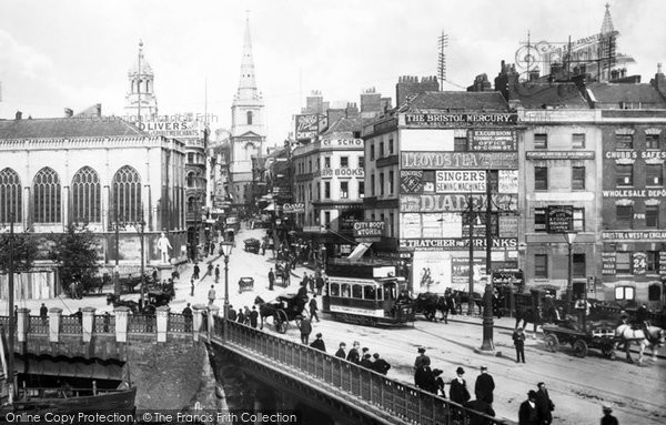
Bombing Raids In 1940
A Memory of Bristol.
Bristol's premier shopping centre was turned into a wasteland of burned out buildings after major bombing raids in 1940, during the Second World War.
Bridge Street Summary
Bridge Street ran from High Street, rising up a gentle slope and turning left to the junction of Mary-le-Port Street, Dolphin Street and Peter Street.
Back of Bridge Street was between Bridge Street and the Floating Harbour (the Floating Harbour took five years to build and was opened on 1 May 1809).
Where Bridge Street stood was known as Worship Street in the Middle Ages and later it was called The Shambles. In 1776 Bridge Street was constructed, taking its name from the adjacent Bristol Bridge.
The street numbers of the buildings ran consecutively along the southern side from Peter Street to High Street (Nos 1-26) and then back along the opposite side to Mary-le-Port Street (Nos 27-46).
The south side (Nos 4-26) was designed by Thomas Paty and, when new, formed what must have been one of the most impressive shopping streets in Bristol. The buildings were in pairs or threes and had identical frontages — four storeys high (including ground floor) and the upper storeys each had three bays with the height of each bay gradually decreasing on each level. All had an attic and basement, the latter having a rear entrance in Back of Bridge Street, which was at street level.
All of the buildings in Bridge Street, except Nos 19-26, were destroyed by (or demolished following) the blitz of 24 November 1940. Apart from Nos 20 and 21, the remaining buildings perished as a result of the air raid on 3 January 1941. Nos 20 and 21 survived the war and remained occupied until they were demolished in October 1964.
All that remains today is part of the cobbled carriageway of Back of Bridge Street and a small section of Bridge Street leading to the car park of an office, both running from High Street.
The High Street ran from Bristol Bridge up a gentle slope with street numbers running consecutively along the east side from the Wine Street corner (Nos 1-28) and then back up the west side (Nos 31 -49).
The junction with Wine Street, Broad Street and Corn Street was the very centre of medieval Bristol and it is here that the High Cross stood for well over 300 years. The Cross commemorated Edwards Ill's charter of 1373, granting county status to the town. It was brightly painted and decorated with four statues of medieval kings. In 1733, at the request of John Vaughan, a silversmith who occupied part of the Dutch House, an impressive building on the High Street and Wine Street corner, and who said that the Cross was in a bad state of repair and a public obstruction, it was moved to College Green. However, it only remained there for a few years, as again it was considered to be an obstruction, and was taken to gardens at Stourhead, Wiltshire, where it remains today. A replica of the upper section also.exists today in the garden at Berkeley Square, Clifton.
Bristol's first public supply of electricity was provided for twenty-six shops in the High Street and Wine Street in August 1893. High Street still exists today, but it is wider than in the pre-war years, as the pavement line on the east side has been moved back. The buildings on the west side (from the Flower Market entrance to Corn Street) are basically as they were pre-war, each with its own interesting features and different from its neighbour.
It is difficult to visualise most of the pre-war Castle Park area having buildings similar to these, with so many different designs - how different it must have been compared to the uniformity of its replacement (Broadmead) today.
Add your comment
You must be signed-in to your Frith account to post a comment.
Add to Album
You must be signed in to save to an album
Sign inSparked a Memory for you?
If this has sparked a memory, why not share it here?


Comments & Feedback