

Places
26 places found.
Those places high-lighted have photos. All locations may have maps, books and memories.
- Cemmaes Road, Powys
- Six Road Ends, County Down
- Road Weedon, Northamptonshire
- Severn Road Bridge, Gloucestershire
- Roade, Northamptonshire
- Berkeley Road, Gloucestershire
- Harling Road, Norfolk
- Road Green, Devon
- Builth Road, Powys
- Cross Roads, Yorkshire
- Steele Road, Borders
- Cross Roads, Devon
- Four Roads, Dyfed
- Road Green, Norfolk
- Biggar Road, Strathclyde
- Clarbeston Road, Dyfed
- Five Roads, Dyfed
- Eccles Road, Norfolk
- Grampound Road, Cornwall
- Morchard Road, Devon
- Wood Road, Greater Manchester
- Four Roads, Isle of Man
- St Columb Road, Cornwall
- Clipiau, Gwynedd (near Cemmaes Road)
- New Road Side, Yorkshire (near Silsden)
- New Road Side, Yorkshire (near Cleckheaton)
Photos
14,329 photos found. Showing results 621 to 640.


Maps
476 maps found.
Books
5 books found. Showing results 745 to 5.
Memories
11,058 memories found. Showing results 311 to 320.
Prefabs
From 1947 I lived in Bedford Road at the top of East Hill but my maternal grandparents lived in the prefabs at the other end of town. The name Blackmans Close sticks in my mind for some reason but I’m not sure if it’s my memory playing tricks - ...Read more
A memory of Dartford by
Doon The Brae In 1950
When my family moved here I was only 7 and there was only a cottage on the left at bottom of Brae and a row of four terraced houses on the left, they were holiday homes for my grandmother and her sisters. We lived there with no ...Read more
A memory of Mid Calder by
Happy Hours Of Reading But Also Destruction.
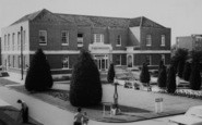
So many hours of reading here in this library. The children's section was in the main door and to the right served by the 2 windows shown on the ground floor. I recall taking out every Arthur Ransome title ...Read more
A memory of Wallington by
Andrew Duncan Home For Boys
At the age of 13 I suffered a nervous breakdown due to problems at home. It was decided by my doctor to send me away from home to give me a break. My mother took me to a mainline station in London where I was handed over ...Read more
A memory of Shiplake by
Featured Buildings.
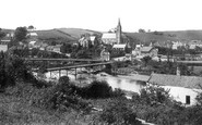
The large building on the left edge of the photograph is Ruswarp Mill. A mill has been here since Saxon times and the first written record of this mill appears in the Domesday book. The name Ruswarp may have originated from the mill. ...Read more
A memory of Ruswarp by
Family Connections.
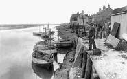
This is my grandfather standing in his whelk house looking at the boats as they unload. He died after a motor car accident on Beach Road in 1934.
A memory of Wells-Next-The-Sea by
Beacholme Camp
I remember vaguely seeing trolley buses and motor buses which were converted into living accomodation, even a tram car with the upstairs windows painted out,that would have been the sleeping quarters I would imagine, and at the ...Read more
A memory of Humberston in 1949 by
Taking A Tumble In 1960
Seeing this photo bought back painful memories! The year before this photo was taken I was in my usual rush to get from Slough Technical School to my home in Langley. This meant changing buses in Slough and if you were very ...Read more
A memory of Slough in 1960 by
Growing Up In Burnham
In this year I was 5 years old, and just starting school in the church hall in Gore Road, which is the road in which I also grew up. I remember Burnham as a small, close-knit community, we went to church every Sunday, it was ...Read more
A memory of Burnham in 1962 by
Orchard Road School
I went to Orchard Road School too and lived in Well Street. I was just looking for old photos when I came across this site and memories.
A memory of South Hackney
Your search returned a large number of results. Please try to refine your search further.
Captions
5,036 captions found. Showing results 745 to 768.

This is the view visitors would see from the main Leeds to Ripon road.

This view looks southwards along Shawfield Road with two complementary shops on each corner. The Brinkworth Stores, on the right, sold groceries and provisions.

parish church of St Peter, with its solid flintstone tower dominating the high street shops and mid-morning traffic in this picture, was originally built by the Normans alongside the spacious Roman road

The wide High Street gave Broadway its name; the road was built to cover two streams that flow either side of the old road. A

The builder and undertaker's shop on the extreme right was on the corner of Church Road, and the frontage of the adjacent cottage is little altered.

During the mid 19th century, new suburban houses were built along the road leading to Ware. As well as dwellings, one or two factories provided work for local people.

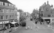
This view from the Mansfield Road junction looks uphill along Nottingham Road, the principal shopping street, lined by mostly 19th- century buildings.

Today the wooden gates are gone, and so is the fountain in the road, erected by the Hender family in memory of their son Leonard, who drowned near Land's End in 1894.

Further east along The Embankment, Newnham Bridge crosses the north branch of the River Ouse at the south end of Tennyson Road. We are looking east from the north bank.

This view is taken looking south towards Oving from Bowling Alley's junction with the North Marston to Whitchurch Road.

If we count four awnings down on the same side of the road, we will just be able to make out Boots.

Already licensed by the mid 18th century, the Angel Inn (left) stands at the junction of the High Street and London Road.

Swanage Station and Station Road (centre right) can be seen beyond the Rectory (bottom right), the home of Rev Thomas Alfred Gurney, which is now Swanwic House.
The wide High Street gave Broadway its name; the road was built to cover two streams that flow either side of the old road. A

Hermitage Road was opened in 1875 to give the people of Hitchin better access to the railway station. The land was given by Frederick Seebohm, who owned the Hermitage Estate.

The road sign (left) at the junction of the High Street and London Road gives the clue.

Witley, further west on the Milford to Petworth road, is in total contrast: its houses are timber-framed, often with the upper storeys tile-hung.

The elegant Georgian house on the right of the road has been converted to offices.To the right of it is the entrance to Botley Mills, an 18th-century mill complex, which is mentioned in the Domesday

The photograph is taken from Arden Road, which is the other side of Grange Road - all the street names have obviously been chosen to evoke a rural past which is now just a memory.

Some picturesque cottages were destroyed to widen these roads and create the roundabout, which now dominates the view.

This view of Station Road looks south-west past the junction to Havelock Street, with the imposing clock tower of the 1903 Co-op store.

From the Hind Hotel we walk down Market Street and turn right down Midland Road. All the buildings on the left have been replaced by the modern Swansgate shopping centre.

This was once an important stopping place on the main road from Taunton to the north Devon area; now, a new road further south has removed much of the traffic from this place.
The photograph is taken from Arden Road, which is the other side of Grange Road - all the street names have obviously been chosen to evoke a rural past which is now just a memory.
Places (26)
Photos (14329)
Memories (11058)
Books (5)
Maps (476)

