Places
Sorry, no places were found that related to your search.
Photos
27 photos found. Showing results 61 to 27.
Maps
Sorry, no maps were found that related to your search.
Books
Sorry, no books were found that related to your search.
Memories
203 memories found. Showing results 31 to 40.
Pavenham 1945 1970
This is the village where I grew up, my parents moving into their very old, somewhat dilapidated cottage at the end of the war. This was 'The Folly' at the eastern end of the village opposite one of Tandy's farms. Why it had that ...Read more
A memory of Pavenham by
Hatch End 50/60/70s Memories
As I’ve only just stumbled on this web page so offer excuses if it’s past its sell by date. I lived in Sylvia Ave Hatch End from 1951 (as a babe in arms) until I married and moved away in 1976. My recollections may now ...Read more
A memory of Hatch End by
Memories Of Aylesbury During The 60s And 70s
I was born in Buckingham Road in 1962 and lived in the same house (no.225) until I left for North Wales in 1985. I have many happy memories of living there, going to the Primary and Junior schools in ...Read more
A memory of Aylesbury by
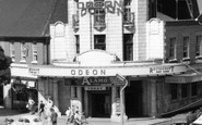
Top Rank
I can remember very vividly going to Top Rank on a Saturday morning with my friends. We all went to Francis Coombe Secondary School. We all had so much fun dancing on these Saturday mornings... loved it...The memories of this and all ...Read more
A memory of Watford in 1968 by
The Tin School And Thurlow Family
I was a pupil at the Tin School in Gilesgate Moor staring in 1954, leaving in 1961. It was at the crossroads of the road that now leads to Tesco, but opposite was the Durham District Services garage where my dad ...Read more
A memory of Durham in 1954 by
Remebering Maindy
I fondly remember Maindy. I was born in Mynachdy Road which is just down the road from Maindy. I worked in the big Wonderloaf bakery on Maindy Road, it was a great bakery I made some great friends there. My sister used to live in ...Read more
A memory of Maindy in 1968 by
Park Road North
We moved to 192 Park Road north in 1967, next door to the shop. We used to visit our nan and aunties at No.160 and always called in to the shop for sweets, the old couple who ran the shop were really nice, they sold great ice ...Read more
A memory of Birkenhead in 1967 by
Langstone Memories
I grew up in Langstone, living at 'Longleat' on Catsash Road from 1961-1973. I attended Langstone Primary School from 1964-1969 and then Caerleon Comprehensive from 1969-1973. 'Longleat' was one of the four ...Read more
A memory of Langstone in 1961 by
Childhood Visit
I have a lasting memory when I was a child probably about 1952 when my parents visited my great uncle Herbert Breed. I think the house that I visited has now gone but I remember it well and I would love to hear from anybody who ...Read more
A memory of Eaton Socon by
The Awakening
On the right of the photograph the second shop belonged to Arthur Sansom, the Newsagents and Confectioners. It has a sign board above the shop front: PICTURE POST. In the Easter holidays of 1959 at the age of 14½, I took my first ...Read more
A memory of Locksbottom
Captions
112 captions found. Showing results 73 to 96.

Up to 1959 the bridge carried all the traffic of the Great North Road; then a new and very welcome by-pass bridge just to the east was opened by Ernest Marples, the Transport Minister.

Newark grew up where the Roman road from Axminster to Lincoln met the medieval Great North Road's predecessor and crossed the River Trent.

The complete sign on the left, Tetley's Fine Ales, was fixed to the old Bowling Green Hotel; it marked the narrowest point on the London to Edinburgh Great North Road.

This town on the old Great North Road was specifically created to trade on its location by the local landowner Idonea de Viponts as early as the 12th century, when the existing Roman road was diverted

Half way between London and Edinburgh on the busy Great North Road, Ferrybridge was a hub, with smaller roads branching off into West Yorkshire.

Our first rural tour heads eastwards, skirting to the north of the Pevensey Levels, those great marshes largely drained during the Middle Ages, and following the road that heads for Ninfield

Little Sutton lies just north-west of Ellesmere Port, and in recent years, along with Great Sutton, it has more or less coalesced with it.

The village lies north of the Seaford road, which crosses the Cuckmere River at Exceat.

Travelling north along the straight road from Brockenhurst brings the traveller to Lyndhurst, an ideal centre for exploring the northern edges of the great forest.

This is the main road southwards, at the junction with Church Street (right). We are looking from North Street into Larmer Street.

This picture was taken eastwards from the north side of East Street, from Mrs Alice E Gale's musical instrument emporium and fancy repository on the corner with Barrack Street (left).

The horse and cart are approaching the old packhorse bridge, which was later to be by-passed by a new road bridge.

The north end of King Street has changed dramatically since 1904: the right hand side is mostly occupied by the backside of Tesco's, and on the left only The Rose pub, with the tall chimney, and the Methodist

The High Street turns north, and it and the town end abruptly at the River Great Ouse, which flows through meadows liable to flooding.

100 acres was considered enough for a park, and the rest was made available for what was to become Park Road with North and South Parades.

This view is looking down from the road bridge; things have changed greatly at Sandy.

This view on the Stainby Road, with the houses on the left fronting onto the High Street, which runs left from the signpost, hardly does justice to this large and attractive village in whose part-Norman

The graceful war memorial recalls the men of Rothwell who fought and died in the Great War.
This view on the Stainby Road, with the houses on the left fronting onto the High Street, which runs left from the signpost, hardly does justice to this large and attractive village in whose part-Norman

The village has been given a sweeping bypass, Broughton Way, on its north side, reducing the volume of traffic negotiating Main Street and the area around St Mary's Church and Old Mill

This is the River Torridge, viewed rfom the Bideford to Torrington road. Trees have grown, and it is not possible to see this view now. The
The village has been given a sweeping bypass, Broughton Way, on its north side, reducing the volume of traffic negotiating Main Street and the area around St Mary's Church and Old Mill

The Bookhams and Fetcham retain old cores amid the great suburban expansion which occurred after World War II; they are in effect western suburbs of Leatherhead across the River Mole.

The most scenic approach to the town is from the north. A
Places (0)
Photos (27)
Memories (203)
Books (0)
Maps (0)

