

Places
2 places found.
Those places high-lighted have photos. All locations may have maps, books and memories.
Photos
11 photos found. Showing results 1 to 11.


Maps
10 maps found.


Books
Sorry, no books were found that related to your search.
Memories
102 memories found. Showing results 1 to 10.
28 Boundary Road
We moved from Coulsdon to Wallington in 1966 where I attended Collingwood School from 1965-1967, I then spent 3 years away at Boarding School in Caterham, before returning in 1970-1972 to attend Wallington Independent School for ...Read more
A memory of Wallington in 1971 by
A Million Miles From A Game Of Football.
I wrote this piece for a writing group exercise in April/May 2019, near my home in NE Scotland. LIttle did I know then that some of the memories would form part of my Mum's Eulogy just three months later. The day ...Read more
A memory of Wembley by
A Grand Opening
We lived briefly in Ferndale Crescent (nr 35). This was defined as Uxbridge then but the boundaries were never quite clear and have become even more blurred with the march of time. It must have been around '57 when we moved in and the ...Read more
A memory of Cowley in 1957 by
An Enchanted Village Lower Boscaswell
I came to know a magic place. Where the sun rises above an enchanted village, follow the two turns in the trackthat time left here unhindered. Sunlight surrounds the three sided island, infusing it with ...Read more
A memory of Lower Boscaswell in 2006 by
Baptist Chapel, New London Road
To the left of the Chelmsford Infirmary and Dispensary (as it was known), stands the Ebenezer Strict Baptist Chapel which was built in 1848. This place of worship is still in regular use in the 21st century despite ...Read more
A memory of Chelmsford in 1970 by
Boundary Road/Frinton Road
Being born in Boundary Road, listening to the yells from West ham on a Saturday, the old Co op butchers and grocery shop, Brampton school/ park, the bakers, the milkman with a horse, playing in the street, calling car ...Read more
A memory of East Ham in 1945
Broughton Astley Pre 1950
This is my second entry about Broughton Astley and may contain some references to items in my first reminisces. As a person 'born and bred' in Broughton Astley, I have fond memories of the village as it was 'in the ...Read more
A memory of Broughton Astley by
Childhood
My Mum, Dad and I moved to the new council houses in Boundaries Road (built on a bombsite) in 1957 when I was 1 year old, so obviously my first memories are of Balham. Dad went to work and Mum and I went shopping every day. These are some of ...Read more
A memory of Balham by
Childhood Days
Wrottesley Park 92 Wrottesley Park, it was a nice address, a suggestion of elegance perhaps, a hint of grandeur even. However there was nothing grand about the place we lived in even though ...Read more
A memory of Wrottesley Park in 1952 by
Childhood In The Village
I lived in Great Wakering (Twyford Avenue) from 1960-65 although my mother had been born and raised there as had her mother and grandparents. I attended the junior school and then the secondary school. The secondary ...Read more
A memory of Great Wakering in 1960 by
Captions
233 captions found. Showing results 1 to 24.

Burford sits right on the county boundary with Herefordshire - the boundary is defined by the River Teme at this point.

Parish boundaries cross and re-cross with those of Myerscough and Barton - one boundary cuts through the bowling green of the Roebuck Inn, as it was known in earlier days.

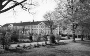
Along the Sywell Road, from the 1950s on, closes of expensive houses were built within the park boundary, retaining many of the specimen trees.

The parish boundary runs along the river, and was formerly the county boundary too, for Welford was in Gloucestershire until 1931.

It served the Sutton New Town development to the east of Manor Park up to the Carshalton parish boundary.

At one time the county boundary, now defined by the River Tamar two miles to the north, ran between the two villages, and the old boundary stone can still be seen beside the road.

Local government boundary changes brought Leighton Buzzard and Linslade together into the town of Leighton- Linslade and placed them both in Bedfordshire.

The parish boundaries meet here with those of Myerscough and Barton; indeed, one boundary cuts through the Roebuck's bowling green.

The line of the paling on the left marked the boundary of the old Borough of Petersfield.

Hocombe Road is the northern boundary of Hiltingbury, and indeed of the borough.

In 1951 the Borough of Swindon purchased Penhill Farm, which lay in the parish of Stratton St Margaret, just outside the borough boundary north of the town, for housing.

The medieval bridge, built about 1340, crosses the Wensum into Bishopgate, which continues around the Cathedral boundary until it becomes Palace Street.
The medieval bridge, built about 1340, crosses the Wensum into Bishopgate, which continues around the Cathedral boundary until it becomes Palace Street.

With rose beds, trees and the river Wye on its boundary, it is small wonder that this is such a popular place.

At one time straddling the county boundary with Huntingdonshire, Everton was listed as Euretone in the Domesday Book.

Close to the county boundary, Roydon retains a timeless air.

Over the Town Bridge, which forms the old county boundary, the power station has been replaced with a shopping centre.

Tetbury lies near the boundary of Gloucestershire and Wiltshire on the long stretch of high road between Stroud and Malmesbury.

Not far beyond the town the journey through Dorset ends as the boundary of Hampshire is reached.
As to the rest of the photograph, the cottages are now one dwelling but even the boundary walls have changed little in over a century.

When Holy Trinity became an ecclesiastical parish in its own right in 1841 it included the West Park area, though this was taken away when the boundaries were adjusted in 1908.

The county boundary between Cambridgeshire and Norfolk actually runs along the middle of the river at this point, so the church is in Norfolk, while the pub is in Cambridgeshire!

Only a fragment of the original boundary wall remains in Judges Walk.

The Waveney forms the boundary between Suffolk and Norfolk, where the boys are fishing.
Places (2)
Photos (11)
Memories (102)
Books (0)
Maps (10)

