

Places
36 places found.
Those places high-lighted have photos. All locations may have maps, books and memories.
- Bangor, County Down
- Newcastle, County Down
- Greyabbey, County Down
- Donaghadee, County Down
- Downpatrick, County Down
- Portaferry, County Down
- Dromore, County Down
- Hillsborough, County Down
- Downings, Republic of Ireland
- Killyleagh, County Down
- Ardglass, County Down
- Rostrevor, County Down
- Dundrum, County Down
- Newtownards, County Down
- Warrenpoint, County Down
- Ballygowan, County Down
- Ballywalter, County Down
- Ballyward, County Down
- Bishops Court, County Down
- Boardmills, County Down
- Culcavy, County Down
- Katesbridge, County Down
- Killough, County Down
- Millisle, County Down
- Portavogie, County Down
- Saul, County Down
- Seaforde, County Down
- The Diamond, County Down
- Audleystown, County Down
- Kearney, County Down
- Annaclone, County Down
- Ballyhalbert, County Down
- Ballymartin, County Down
- Clare, County Down
- Conlig, County Down
- Dollingstown, County Down
Photos
945 photos found. Showing results 221 to 240.


Maps
459 maps found.


Books
49 books found. Showing results 265 to 288.
Memories
8,169 memories found. Showing results 111 to 120.
Hilly Fields
Situated at the top of our road, as young children Hilly Fields was something quite magical. During winter time we would trek our home made sledges over to toboggan hill and hurtle down to the brook at the bottom of the hill at breakneck ...Read more
A memory of Enfield in 1950 by

My Mums Home
My mum moved here when she was about 7 years old in 1959. Her mum and dad Mr and Mrs Claus owned the fish shop third closest to the camera. Her neighbour Mrs Sansby lived in the middle house. The house nearest to the camera is where my ...Read more
A memory of Stilton by
Working In Dartmouth Road
I worked at the gas board showroom on Dartmouth Road. It was next door to the bank on the corner of London Road. As well as selling gas appliances and receiving payment on gas bills we used to sell bags of "shillingsis!" for ...Read more
A memory of Purley by
The Donkey Path
Re The Donkey path. I think Joanne is wrong - I know the embankment you speak of, there used to be a miniature railway which ran along the bottom of the embankment from the Prom entrance of Erias Park along to the Pier. The Donkey ...Read more
A memory of Old Colwyn in 1980 by
Early Days Of Blackhill
My name is Stephen Yallop. I lived in Blackhill from the early 1960s. I used to live in Gallagher Terrace. I went to the Tin Mill infant school, I remember the teachers as Mrs Dunne the headmistress. Mrs Ferguson and ...Read more
A memory of Blackhill in 1966 by
Number 2 Montague Terrace
Barbara Brian. I loved reading your memories of Montague Terrace and I thank you for them. Were you the young Miss Andrews that rode that posh bicycle and lived behind the shop and did your dad at times teach tap dancing ...Read more
A memory of Bishopstoke in 1930 by
Those Lazy Hazy Days Of Delamere
I have so many memories of Delamere but unlike the others who have written on this page my recall of the names are not so good. I tend to see things as pictures (and have a good memory for faces) and have vivid ...Read more
A memory of Delamere in 1966 by
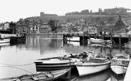
Power Boats
The wooden clinker built boat, painted white in the lower right of the picture, was one of a pair of fast boats that the late Arthur Shippey and Tom Louis ran from coffee house end steps. They would call loudly ""half hour trips round the ...Read more
A memory of Whitby in 1953 by
Evacuation Ww2
I recall being evacuated to Llansaint from London as a child of 7. I lived in a small sweet shop in the the village with a family named Phillips, or Philips. I am now 74 so my memories are not too sharp with regards to names and ...Read more
A memory of Llansaint in 1941 by
Clifton Park
I used to live in tree-lined Lister Street. All I had to do was climb over the back wall to the rear of my house to get into Clifton Park. I remember Sunday School held at the Bandstand: 'Sunshine Corner always jolly fine, is for ...Read more
A memory of Rotherham in 1940 by
Captions
2,258 captions found. Showing results 265 to 288.

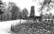
Here, children are playing on the steps leading down to the bandstand, which has now gone. Housing has now appeared beyond the fringes of the park.

The motor car is well provided for in this picture, which looks down the High Street to the Abbey gateway. On the right are the Ford Service Depot and Pratt's Petrol.

The Fosse Way runs down from the right of this picture to meet the Avon and follow it to Bath, three miles away.

Spacious houses and hotels are situated around a dramatic woodland chine leading down to the sea.

The Cat and Cracker got its name in 1954, when the brewers Style & Winch Ltd of Maidstone named it after the catalytic cracker, which breaks down crude oil, and was used by the nearby Anglo- Iranian

The lawn of a country house sweeps down to the water; a pile of mown grass can be seen on the right.

The winding road out of Newlyn rounds Penlee Point then dips down to this celebrated fishing village that nestles within stout stone breakwaters. At its back it is fringed by hills.

Proposals were drawn up for a new pavilion, indoor nets, and a banqueting suite at Queen's Park, but were turned down by Chesterfield Borough Council.

Simply push the three rails down, and step over! This one is the only example of a clapper stile in Cambridgeshire.

We are looking down Penrith's main shopping street.The scene has not changed much since Victorian days, except for the fact that the horses have by now disappeared and have been replaced by motor vehicles

The pinnacled Victorian Parish Church of St John, Cragg Vale, with its crowded graveyard, looks down the isolated, wooded valley where the coiners once operated, far from the eyes of the law and authority

These immaculately thatched cottages still exist, although they are rather run-down nowadays. Today the three villages of South, Middle and North Littleton all virtually run into each other.

The impressive facade of the Hotel Metropole, with the Ship Hotel next door, faced the end of the Jetty to greet the thousands of holidaymakers who travelled down on the paddle steamers.

Emery Down stands on the frontier of some of the wildest scenery in the New Forest. Badgers live deep in the woods, deer can be seen by the patient watcher, and buzzards circle overhead.

This is another postern gate surviving from the Town Wall, which was built to defend Richmond against Scottish raids shortly before the Battle of Bannockburn.

She was provided with milk by two deer; when a huntsman came after them with dogs, he was struck down by God and died instantly.

From a slightly different viewpoint, this picture looks across Town Hall Gardens and the Chatham rooftops towards the Downs beyond.

Here we are looking down Queen Street from the junction with Kettering Road, towards the centre of the village where the spire of the church can be seen in the distance.

By 1839, the parish church of Holy Trinity was becoming a little run down.

Leylandii trees line the nearside of the plot, but the view down the road remains very pastoral.

It burned down in 1928.

Part of the village is clustered around the top of a ravine; notice the steep flight of steps in the lower foreground dropping away down toward the sea.

A scene that was once familiar in many villages up and down the country. Notice the petrol pump on the right.

In 1930 a flash flood swept down Laxey Valley with sufficient force to destroy the central section of the T-rocker, though it was later restored.
Places (198)
Photos (945)
Memories (8169)
Books (49)
Maps (459)

