

Places
25 places found.
Those places high-lighted have photos. All locations may have maps, books and memories.
- East Wall, Republic of Ireland
- Pell Wall, Shropshire
- Wall, Northumberland
- Heddon-on-the-Wall, Northumberland
- Walls, Shetland Islands
- Wall, Cornwall
- Wall, Staffordshire
- East Wall, Shropshire
- Wall End, Kent
- Hobbs Wall, Avon
- Wall Bank, Shropshire
- Wall Nook, Durham
- Knowl Wall, Staffordshire
- Hazelton Walls, Fife
- Wall Mead, Avon
- Mid Walls, Shetland Islands
- Greetland Wall Nook, Yorkshire
- Aston le Walls, Northamptonshire
- Wall Heath, West Midlands
- Wall Hill, Greater Manchester
- Wall End, Cumbria (near Millom)
- Wall under Heywood, Shropshire
- Dale of Walls, Shetland Islands
- Bridge of Walls, Shetland Islands
- Hole-in-the Wall, Hereford & Worcester
Photos
516 photos found. Showing results 861 to 516.
Maps
172 maps found.
Books
Sorry, no books were found that related to your search.
Memories
1,989 memories found. Showing results 431 to 440.
Those Were The Days 1
Growing up in the 50s and 60s in London's East End (well the Essex side of it). I was born on April 14th 1952 at Upney Hospital. I attended Northbury infants and junior schools and then went to Eastbury Secondary Modern. I ...Read more
A memory of Barking in 1950 by
Good Times
I loved Hinchingbrooke School growing up and the house just intrigued me. I remember my first year of sixth form in the house and my friends and I decided to look around the grounds where we came across the graves of Oliver Cromwell's ...Read more
A memory of Huntingdon in 2007
Schoolboy Caddy
I spent many a happy moment as a schoolboy caddy at BBGC at the end of the 50s and early 60s. It was also a very useful source of pocket money. I regularly caddied for local businessmen, the likes of the MD of Weston's Biscuits, ...Read more
A memory of Burnham by

Holidays In Lightwater
As a very young child coming from Berkshire, I with a brother have spent many years of enjoyment staying with relatives in Grassmere Road in the house where my mother along with other members grew up, The house seemed large ...Read more
A memory of Lightwater by
Son Of Sgt Bruce Krrc
My father was stationed at Chisledon Camp from 1939 to 1942. Living in Littlehampton on the south coast, threatened with invasion, my mother rented the end thatched cottage of the row of cottages which face the railway line ...Read more
A memory of Chiseldon in 1940 by
A Walk From Shotgate Baptist Church To Wick Lane
My name is Kevin Mears, I lived in Wickford from my birth in 1958 until I got married in 1980. I shall describe my memories of Wickford as a couple of walks around the Wickford area. My first walk ...Read more
A memory of Wickford by
A Walk From Wickford High Street Down The Rettendon Raod
My name is Kevin Mears, I lived in Wickford from my birth in 1958 until I got married in 1980. I shall describe my memories of Wickford in the 1960s and 1970s as a couple of walks around the ...Read more
A memory of Wickford by
The Blackmore Family
A little more information on the Blackmore family, they moved from Ide to become the licences of the Sturt Arms, I would say around 1880, Albert was born 1886 and his sister Alice in 1874. Miss Lillian Wreford sold Albert ...Read more
A memory of Down St Mary in 1940 by
Re The Buffs
The Royal order of Buffalos..... Next door but one to the nurses home (as was), now a nursing home. I was born in Highfield hospital, Mill Lane, lived in Wallasey until I was 62 and now live in the north of Scotland. When I was a ...Read more
A memory of Wallasey in 1993 by
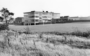
School Days In The Sixties.
I attended this school between 1968 and 1972. I was also a pupil at Hazel Leys Infants and Juniors. Both these schools were on the same site as the Secondary Modern but not shown in this 1955 photo. I presume the Juniors is ...Read more
A memory of Corby in 1962 by
Captions
1,668 captions found. Showing results 1,033 to 1,056.

The view looks north-westwards from a peninsula that is rounded off by the great stone walls of the Nothe Fort.

The main ruins comprise parts of the east walls of the transepts, part of the chancel and a vaulted gatehouse.

The shop on the right is a branch of W H Smith, with the old style of sign standing proud from the wall - some of these still survive on a few branches around the country.

Close by is Buscot Park, famous for its walled gardens, extensive grounds and lake, and the Faringdon art collection. It is open to the public under the National Trust.

This is the heart of Hardy Country - Hardy called this village Lew Everard. We are looking eastwards from Rectory Lane.

from the mid 15th century it was extensively restored in 1866 at a cost of £1,200, mostly paid thanks to the benefaction of Mr Robert Copeman, many of whose ancestors are buried within its walls

In view of the relatively young age of the church when the photograph was taken, it is surprising to see so much ivy climbing up the walls. This has now been removed.

The 50 steps alongside the wall (centre) lead to a churchyard with one of the finest views in Devon.

The 50 steps alongside the wall (centre) lead to a churchyard with one of the finest views in Devon.

The dovecote, where pigeons were bred as a ready source of meat throughout the year, is set amidst walled gardens.

We have now passed through Stonebow into the southern part of the High Street, which grew up along the old Roman road south of the walled city.

This is the Green Bridge, over which traffic had to pass before entering through the Green Gate in the medi- eval walls.

The Twyn and its surrounding wall were built in the 1890s with money from the Barry Railway Company when they purchased a small piece of the common from the parish.

The massive twin-towered Westgate is the only survivor of the six medieval gates which once interrupted the path of the Norman wall around the city. The rest were pulled down in 1781.
The main ruins comprise parts of the east walls of the transepts, part of the chancel and a vaulted gatehouse.

These Riverside Gardens have been reduced to a narrow stone walled strip to accommodate a widened Barry Avenue.

In this photograph we see it as a branch office of the Alliance Assurance Company - notice the Alliance sign on the right-hand edge of the wall.

It contains some 15th century woodcarvings from Danbury church - as well as some wall-stencilling identical to that in the church - and oak beams that came from a ship.

The town hall not only housed the council: there were law courts, facilities for lectures, public meetings and for music festivals.

Parsons Fee leads south-west from Market Square past Prebendal House, the home of John Wilkes, the radical MP for Aylesbury from 1757 to 1764, and behind high brick walls.

Lincoln's celebrated Stone Bow is the later 15th-century medieval gate into the walled town, above which is the basically Tudor city Guildhall.

One of the surviving features is the recently excavated Roman amphitheatre; it was built in the 1st century AD to accommodate over 4,000 spectators, who sat on wooden seats above the surrounding walls.

The clock turret of Moreton's most prominent building displays the date of its construction as 1887, and on the south wall is the coat of arms of the Redesdale family of Batsford Park who

The fortified manor of the Wynn family, built at various stages from around 1490, is seen with carefully tended beds and wisteria and ivy-clad walls.
Places (25)
Photos (516)
Memories (1989)
Books (0)
Maps (172)

