

Places
26 places found.
Those places high-lighted have photos. All locations may have maps, books and memories.
- Town End, Derbyshire
- Town End, Buckinghamshire
- Town's End, Somerset
- Towns End, Dorset
- Town End, Merseyside
- Town End, Cambridgeshire
- Town's End, Buckinghamshire
- West End Town, Northumberland
- Bolton Town End, Lancashire
- Kearby Town End, Yorkshire
- Town End, Cumbria (near Grange-Over-Sands)
- Town End, Cumbria (near Bowness-On-Windermere)
- Town End, Yorkshire (near Huddersfield)
- Town End, Yorkshire (near Wilberfoss)
- Town End, Cumbria (near Appleby-in-Westmorland)
- Town's End, Dorset (near Melbury Osmond)
- Town's End, Dorset (near Swanage)
- Town End, Cumbria (near Ambleside)
- Town's End, Dorset (near Bere Regis)
- Town End, Cumbria (near Ambleside)
- Town End, Cumbria (near Lakeside)
- Town End, Cumbria (near Kirkby Lonsdale)
- West-end Town, South Glamorgan
- Townend, Derbyshire
- Townend, Strathclyde (near Dumbarton)
- Townend, Staffordshire (near Stone)
Photos
26 photos found. Showing results 4,061 to 26.
Maps
195 maps found.
Books
160 books found. Showing results 4,873 to 4,896.
Memories
3,720 memories found. Showing results 2,031 to 2,040.
Lane End Born Bred From 1956
I grew up in Park Lane, this is the eastern side of Lane End, and then consisted of mostly 1940s- & 1950s-built council houses. I grew up in Coronation Crescent, a semi, 3 bed council house. These were ...Read more
A memory of Lane End by
Update On Castle Street
The houses in Castle Street have been knocked down some 20 years ago. I used to live in no 18 and used to play in the castle grounds since we had no garden.
A memory of Guildford by
Life On The Farm At Kettlethorpe
We moved to Park Farm Kettlethorpe when I was 7. The family at this time was reduced to Mum and Dad, Eileen, Brian, Maureen and Gillian. At first we lived in a semi detatched house at the top of the ...Read more
A memory of Kettlethorpe in 1955 by
Huntcliffe Cottages
On this photograph there is a little 'bump' on the horizon just below Warsett. That 'bump' is 3 railway cottages and my Dad lived in No. l with his parents and brother and sister around 1912 - 13ish when he was school ...Read more
A memory of Saltburn-By-The-Sea in 1947 by
420 Rimmington Row My Home
I lived at the above address with my mum Evelyn and dad Jim Hoyle who for a time was the caretaker at the Stocksbridge C Of E school just across the road. My sisters Valerie and Vivien and I lived with with our parents ...Read more
A memory of Stocksbridge in 1956 by
Forge Farm
Just found this site while looking for Chinley which I believe is close by. Forge Farm memories of the fun times we had as children hop picking with nan and gran-dad, dad and mum, aunts and uncles and of course my siblings. At that time ...Read more
A memory of Goudhurst in 1953 by
1940 To 1945
My name is Orin, Belgian born, and I lived at 68 Hazelmire Road, we lived right behind Petts Wood woods, there was a tree which we called the Crocodile, I still have a piece of this fallen tree...so many beautiful memories, although it ...Read more
A memory of Petts Wood by
Summer Holidays
I was born in Brewery Yard, Great Haywood. After the war my mum moved to Notting Hill, London, so in the summer holidays my sister and I would stay at Nan & Grandads in the village. Mum {Eileen Bailey} played the piano in the ...Read more
A memory of Great Haywood in 1954 by
Hatchford Church
My father, Capt. F.C. Dyer used to play the organ at Hatchford Church until his death in 1950. It was a pump organ and Bubbles was the name of the hunchback who pumped the organ. We lived in the Semaphore Tower up on Chatley Heath ...Read more
A memory of Cobham in 1940 by
Grandads Pig Farm
My memories of Mitcham are primarily those of days spent at my grandparents' house. My grandad was Sidney Clark, my nan for some reason unknown to me was "Nanny Mick". My grandfather had a pig farm at the bottom end of Aberdeen ...Read more
A memory of Mitcham by
Captions
5,111 captions found. Showing results 4,873 to 4,896.

This old woollen mill was vacant and decaying in 1815 when it was taken over by John Heathcote, a lace manufacturer, who moved here from Leicester after the Luddite riots.

This view looks down Steep Hill from nearer Castle Hill, with the jettied and timber-framed Spinning Wheel Restaurant on the far left, its later Georgian bow windows tucking under the jetty.

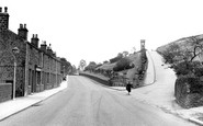
There is not much traffic—a car and a motorcycle with pillion passenger—in this view of the road running down from Dunmail Raise into Grasmere.

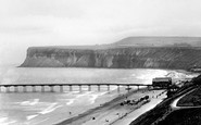
The rugged nature and scale of the cliffs at Beachy Head, seen here to the east of the lighthouse, is clearly shown in this view.

It is a listed building and is described as '2 storeys, rough cast on brick with thatch roof, the eaves swept down on west side to form veranda with flint and rubble columns'.

A country lane, a straggle of houses and open countryside is all we see as we look down Collier Row Road with the Church of the Ascension on the right.

The view down the High Street has changed very little, but the increased volume of traffic has brought traffic lights to the junction with the road to Over.

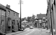
Aptly named, this wide street wends its way down to the river. In the foreground stands the Bear Hotel, formerly The Bear's Head, built around 1868, with its mock-Tudor façade.

A peaceful view of Howth harbour, looking along the sea wall towards the tower and the east pier. Rowing boats are moored in the harbour.

This classic view looks west down High Street to the Wey valley and beyond to Guildown (The Mount).

The men standing at the door on the left are customers of the Lion Inn, which burned down on 8 November 1908 and was never rebuilt. The Congregational Chapel in the background was built in 1831.

Here we are looking east towards the hill down to the Hamble River. On the right we have Robertson, a chemist, and the local post office adding to the many shopping facilities for the inhabitants.

Easily the most famous and most photographed building in Ambleside is Bridge House, a tiny one-up, one-down building constructed on a bridge over the Stock Beck.

This view looks from Market Square down Friargate.

ONE of the great joys of Exmouth is its beautiful setting, caught magnificently between the sea, the long Exe estuary and the wilder countryside of heath and cliff that so defines east Devon, offering

She joined the Women's Voluntary Service (WVS) and worked in the basement of Ormskirk Hospital, operating the switchboard for the hospital and also manning telephones for the WVS, checking the

The same road widening seen in the previous picture led to the demolition of the white-painted end house in this shot. One would not now dream of walking down the centre of this road.

In the 19th century the church was heavily 'restored and improved in a hearty manner' by Sir George Gilbert Scott, a nationally famous architect, but the building still retains its medieval appearance

This view was taken from Nettlecombe looking towards the thatched Knapp House and St Mary's Parish Church (centre).

The fountain dates from the 18th century, and water flows down a channel made in 1803 'for cleansing and fire fighting'.

Whitehall is the traditional home of the offices of goverment and here are the Treasury, the Home Office, the Privy Council and, of course, the entrance to Downing Street.

This view was taken in Albert Road looking down Widnes Road.

Set in the heart of Broadland, it has been called 'little Venice', with soft green lawns spreading down to the water's edge.

We are looking eastwards back down the street. The centre house with two-storeyed mullion windows is 16th-century. Note the excellent thatch.
Places (26)
Photos (26)
Memories (3720)
Books (160)
Maps (195)

