Merry Christmas & Happy New Year!
Christmas Deliveries: If you placed an order on or before midday on Friday 19th December for Christmas delivery it was despatched before the Royal Mail or Parcel Force deadline and therefore should be received in time for Christmas. Orders placed after midday on Friday 19th December will be delivered in the New Year.
Please Note: Our offices and factory are now closed until Monday 5th January when we will be pleased to deal with any queries that have arisen during the holiday period.
During the holiday our Gift Cards may still be ordered for any last minute orders and will be sent automatically by email direct to your recipient - see here: Gift Cards
Places
Sorry, no places were found that related to your search.
Photos
Sorry, no photos were found that related to your search.
Maps
7,034 maps found.


Books
163 books found. Showing results 8,209 to 8,232.
Memories
22,913 memories found. Showing results 3,421 to 3,430.
School Days
I lived at 11, wickham highams park until I got married in 1968. Went to Selwyn infants which was mixed then went next door to the junior girls school as the boys school was the otherside of the infants. At age 11 went to Sidney ...Read more
A memory of Highams Park in 1947 by
Northcliffe County Secondary School 1965
Does anyone remember or attended Northcliffe County Secondary School in Shipley during the early 60's. I can remember the Headmaster being Mr Bartholemew. Our RI teacher was Mr Scott, Geography teacher Mrs ...Read more
A memory of Shipley in 1965 by
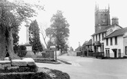
The Colerne Cross Tree, Old And New.
The Colerne 'cross-tree', as it was called, which can be seen at the left side of this photograph of the market square and church, was an elm, I think. It was already looking pretty ancient when I lived there in ...Read more
A memory of Colerne in 1940 by
Fond Memories
I attended Holker School between 1959 and 1963 and can recall the Rowes quite clearly. I made a habit of knocking at their door most morning play times when we were able to buy small packets of peanuts for two old pence from them. They ...Read more
A memory of Cark in 1959 by
Stoneleigh
I was born at home on Waverley Road in Stoneleigh in 1940 during the Bllitz. I lived there until I emigrated to Canada in 1962. This photo brings back many memories. I remember Atkinsons, the Newsagent on the left of the picture. ...Read more
A memory of Stoneleigh in 1960 by
Front Street Bells Close
I was born in Corbridge in Dilston Hall when it was a maternity home. My parents lived at No 1 Front Street Bells Close and I have some fantastic memories of my life there. I remember all of the neighbours and our ...Read more
A memory of Denton Burn in 1860 by
Swiming Outdoors And Wardown Park
I have fond memories of Luton, I came with my mates from Markyate village on the 364 London transport bus to Park Sq. we would then board a red corporation bus for the swimming pool off the New Bedford road at ...Read more
A memory of Luton in 1952 by
Fond Memories
My grandfather, Reginald Dean, of 130 Bridge Road, Oulton Broad, used to moor his boat- the Eel- in the Staithe. I used to walk there ever day with him to pump it out and make a brew in the summer holidays. his pipe kept the mossies at bay. Great times.
A memory of Broads, The in 1956 by
Spivack Jewellers
I was born in Welldon Crescent in 1946 and lived there for over 20 years. My uncle worked as a french polisher for J. Sainsbury and was often working at the Harrow shop. I'm now living in Cyprus and have become friends with a ...Read more
A memory of Harrow by
Your search returned a large number of results. Please try to refine your search further.
Captions
9,654 captions found. Showing results 8,209 to 8,232.

This view is taken from Milford Road, with Farnham Road at the right curving past the former blacksmith's forge, which is now a cottage, The Old Forge.

East from Claygate and across the Hogsmill river valley, the route reaches Ewell, now by-passed by the A24 London to Worthing road.

Middle Beach (foreground) at Studland, is overlooked by the 1943-built Fort Henry on Redend Point (right-hand clifftop), which Canadian Engineers named for their home base in Ontario.

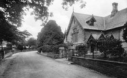
In 1899 the Board of Governors of the Grammar School commissioned the building of a library at the western end of the school buildings (left).

This view was taken in the same year as G66012 from the opposite end of the Applegarth at Whitby Lane, with the kissing gates in the foreground.

The small village of Trelleck on the Chepstow to Monmouth road is often remarked upon for having such a large church.

Dedicated to St George of England (note the full title), the parish church at Toddington is so similar to its counterpart in Houghton Regis, just a few miles away, that it should be suggested that only

At the east end of the Parade, by the last slipway, is the Island Sailing Club (left), which was founded in 1889, and is amongst the largest in the world.

County Hall was built in 1882 and was the administrative headquarters of Lancashire County Council.

The now-vanished Lytham Pier, built in 1864, was badly damaged by a storm on 6 October 1903. Two sand barges of 300 tons dragged their anchors, drifted and cut the pier in half.

The Round House, re-named Rose Cottage, stands at the centre of the village - it was a toll house. The expense of maintaining roads was met by payment of tolls.

Lord Nelson was a pupil for three years at the town's Paston Grammar School.

The Ordnance Survey maps of 1884 and 1905 show a massive loss of coastline along the cliff.

The pretty village of Shackleford, west of Godalming, has a mixture of houses in different styles, as evidenced here by the creeper-clad building on the right, the tall-chimneyed cottages with their neatly

A postman on his round chats to two local residents opposite the King's Head pub (right), where empty barrels and several crates of bottles await collection by the brewer's dray.

Just a mile inland from Hinderwell, the village of Ellerby is centred on this late 17th-century hostelry.

The ancient name for the village is Barelegh (meaning 'wasteland'), but lush meadows now support flocks of sheep.

Two miles south of Langold, Carlton in Lindrick is a village of two parts, the original village to the south and a large former colliery village with hard red brick semi-detached houses.

Helsby's name means the 'village on a ledge', but it would be more correct to say that it nestles just under the ledge or outcrop of rock seen here.

HMS' St Vincent' (120 guns) was completed in 1815, but too late to take an active part in the Napoleonic Wars.

This view is at the less interesting east end of Main Road, away from the parish church, the moat, the Georgian rectory and Shakespeare Farmhouse, where the bard is reputed to have stayed.

The River Windrush threads through Bourton, carpeted on either bank by broad greens.

Presiding over the town is the 120ft high pinnacle-topped tower of St James', which dates from the 15th century.

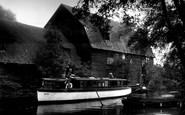
There has been a watermill at Houghton since 974. Mills were frequently rebuilt, and this mill replaces one that was burnt down in the 17th century.
Places (0)
Photos (0)
Memories (22913)
Books (163)
Maps (7034)

