

Places
36 places found.
Those places high-lighted have photos. All locations may have maps, books and memories.
- Pentre-cwrt, Dyfed
- Pentre Halkyn, Clwyd
- Pentre, Mid Glamorgan
- Ton Pentre, Mid Glamorgan
- Pentre, Powys (near Llangynog)
- Pentre, Powys (near Guilsfield)
- Pentre, Powys (near Bishop's Castle)
- Pentre, Dyfed (near Pontyates)
- Pentre, Powys (near Newtown)
- Pentre, Clwyd (near Mold)
- Pentre, Clwyd (near Ruabon)
- Pentre, Shropshire (near Chirk)
- Pentre, Clwyd (near Hawarden)
- Pentre, Clwyd (near Chirk)
- Pentre, Clwyd (near Ruthin)
- Pentre, Clwyd (near Mold)
- Pentre, Shropshire (near Oswestry)
- Pentre, Powys (near Welshpool)
- Pentre, Clwyd (near Mold)
- Pentre, Shropshire (near Forton)
- Pentre Broughton, Clwyd
- Pentre Gwynfryn, Gwynedd
- Pentre Maelor, Clwyd
- Pentre-clawdd, Shropshire
- Pentre Galar, Dyfed
- Pentre Llifior, Powys
- Pentre-cefn, Shropshire
- Pentre-Gwenlais, Dyfed
- Pentre-Poeth, Dyfed
- Burntwood Pentre, Clwyd
- Pentre Berw, Gwynedd
- Pentre Hodre, Shropshire
- Pentre Llanrhaeadr, Clwyd
- Pentre-celyn, Clwyd
- Pentre Cilgwyn, Clwyd
- Pentre Morgan, Dyfed
Photos
98 photos found. Showing results 521 to 98.
Maps
316 maps found.
Books
2 books found. Showing results 625 to 2.
Memories
1,253 memories found. Showing results 261 to 270.
Mandrake Road
My siblings and I were all born at Weir maternity hospital in Balham, we lived on Mandrake road and we all went to Fircroft primary school opposite our house. I was at Fircroft from 1976-1982. Mr. Chaimings was the headmaster then, Mr ...Read more
A memory of Tooting by
Bordon Infant School Station Road Now The Phoenix Centre
Teachers. - Mrs Boyle, Mrs Clover, Mrs Parrott. Head teacher - Mrs Bingham - she had the library books, stamp and cards in her office upstairs. Playground surrounded the building and constructed ...Read more
A memory of Bordon by
Lost Opportunity?
I was born in Drayton in 1943 and was at Solent Road School and the Northern Grammar School for Boys. I then went to London University and subsequently worked abroad while returning to Portsmouth regularly where I have my UK Home for ...Read more
A memory of Portsmouth by
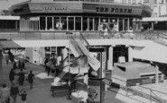
A Great Pub, Fit For An Emperor!
Ah the Forum! What a fine and individual pub! I often wondered why the brewers, Ind Coope, called their pub this! Anyone any ideas????? I was at Croydon college around the time this photo was taken and rather than going to ...Read more
A memory of Croydon by
Eastern Electricity Board Training Centre Harold Hill
I started at Harold hill in September 1966 as An apprentice electrical fitter. My lodgings were in Clock house Lane and I went to college at Hornchurch where I spent many a happy hour in the ...Read more
A memory of Harold Hill by
My Fenny Stratford Childhood
Having recently by chance spoken with someone who knew Fenny Stratford I was prompted to start looking on the internet and came across this site and for what it’s worth decided to record my memories. I was born in ...Read more
A memory of Fenny Stratford by
Best Childhood Ever
We moved to the prefabs in South Road, South Ockendon in 1949 From London, my sister and I started school in the village school the headmaster was Mr Impy after that we went to the new school which was called Mardyke School I ...Read more
A memory of South Ockendon by
First Visit Away From Home
I believe it was 1967 when I first visited .the trip was arranged between Appleby Magna juniors and local Packington juniors under the Leicester education board . My first sight was magical and although a few were ...Read more
A memory of Aberglaslyn Hall by
Harrow Driving School Rayners Lane 1985 1986 Approx
Memories of getting the tube from Arnos Grove to Rayners Lane and then the long walk up Imperial Drive - until reaching the driving centre. The set up included traffic lights, zebra crossings, ...Read more
A memory of Harrow by
Wood House
Early C20 formal gardens and parkland designed and landscaped by Thomas Mawson and implemented by Robert Mawson of the Lakeland Nurseries, Windermere, surrounding a house designed by Dan Gibson with a ground plan by Thomas ...Read more
A memory of Taw Green by
Captions
3,593 captions found. Showing results 625 to 648.
St Giles Cripplegate Church survived severe Second World War bombing to stand in the centre of development which was completed in the early 1980s.

After the war, the remains of the city centre were demolished to make way for a new, more regular street plan. In this picture the new Post Office is still under construction on the right.

Being within a few miles of the village, they helped Wroxham become the major centre for cruising that it is today.

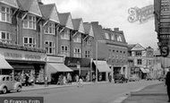
These shops face the small bus shelter in the centre of S258082. Above G W Ager's 'Complete Outfitters' is an advertisement for Dunlop boots.

Fordingbridge is now a busy market town, though in former days it was an important industrial centre, renowned for the manufacture of sailcloth and canvas.

The 'Miners' Welfare' was the community and cultural centre for many South Yorkshire and other coal mining villages.

During the latter half of the 20th century the mill was restored and opened to visitors as a craft centre and art gallery.

Here we are looking down Queen Street from the junction with Kettering Road, towards the centre of the village where the spire of the church can be seen in the distance.

The quarry cottages are long gone, but the Dartmoor Inn (centre) is a popular watering-hole still.

The Winged Spur (in the background, on the right) in the village centre is still a traditional country pub with a warm welcome for local residents and visitors.

Two little girls walk arm-in-arm across the tree-shaded ancient packhorse bridge which crosses Clapham Beck in the centre of the village.

The commercial centre of the town for over a hundred years, this area had long-established tradesmen's shops.

Many locals still work in and around Ealing, and the town has retained its excellent shopping centre.

In the centre of the picture two men are working on an another unusual boat, a motorised wherry - notice the shortened mast.

A building can just be seen through the trees in the centre of the photograph.

Note the large number of beach vendors, and the dark-rooms of two rival photographers in the centre of the picture.

Children with hoops pose for the photographer in the centre of the picture.The octagonal building on the left is a newspaper

The large trees have gone, and the Arena Leisure Centre now stands in their place.

The building in the centre background is the entrance to Lytham Pier.

The sign of the popular White Lion Hotel is just visible in the centre of this photograph and Barclays Bank (now Ladbrokes) is on the far left.

Sandgate Castle, built in 1573, was so altered in 1806 to make a defence against the feared invasion by Napoleon that it resembled the Martello towers built along the coast (see centre

Just before the turn of the century, Datchet suffered serious flooding when the swollen Thames caused a pond in the centre of the village to overflow.

Made redundant, and disused for some years, this fine church is now a craft centre.

This view from the centre of Rowsley has the Peacock Hotel, its famous landmark, on the right.
Places (57)
Photos (98)
Memories (1253)
Books (2)
Maps (316)

