

Places
36 places found.
Those places high-lighted have photos. All locations may have maps, books and memories.
- Pentre-cwrt, Dyfed
- Pentre Halkyn, Clwyd
- Pentre, Mid Glamorgan
- Ton Pentre, Mid Glamorgan
- Pentre, Powys (near Llangynog)
- Pentre, Powys (near Guilsfield)
- Pentre, Powys (near Bishop's Castle)
- Pentre, Dyfed (near Pontyates)
- Pentre, Powys (near Newtown)
- Pentre, Clwyd (near Mold)
- Pentre, Clwyd (near Ruabon)
- Pentre, Shropshire (near Chirk)
- Pentre, Clwyd (near Hawarden)
- Pentre, Clwyd (near Chirk)
- Pentre, Clwyd (near Ruthin)
- Pentre, Clwyd (near Mold)
- Pentre, Shropshire (near Oswestry)
- Pentre, Powys (near Welshpool)
- Pentre, Clwyd (near Mold)
- Pentre, Shropshire (near Forton)
- Pentre Broughton, Clwyd
- Pentre Gwynfryn, Gwynedd
- Pentre Maelor, Clwyd
- Pentre-clawdd, Shropshire
- Pentre Galar, Dyfed
- Pentre Llifior, Powys
- Pentre-cefn, Shropshire
- Pentre-Gwenlais, Dyfed
- Pentre-Poeth, Dyfed
- Burntwood Pentre, Clwyd
- Pentre Berw, Gwynedd
- Pentre Hodre, Shropshire
- Pentre Llanrhaeadr, Clwyd
- Pentre-celyn, Clwyd
- Pentre Cilgwyn, Clwyd
- Pentre Morgan, Dyfed
Photos
98 photos found. Showing results 1,881 to 98.
Maps
316 maps found.
Books
2 books found. Showing results 2,257 to 2.
Memories
1,253 memories found. Showing results 941 to 950.
Gosforth 1960s / 1970s
A friend and I were reminiscing recently. Our conversation came round to an old shop at the bottom of Salters Road, next to the double bus stops opposite The Globe. We could recall it only sold sweets and tobacco but couldn't ...Read more
A memory of Gosforth by
H Ounslow In The 30's
i LIVED IN HOUNSLOW from 1932 TILL 1967 Went to Spring Grove Central school was marred at the Congregational Church my wife had my son there I did some part time teaching at Isleworth Polytechnic and subsequently Spring Grove ...Read more
A memory of Hounslow by
The Market
Being born and raised in Halifax I remember how grim it was to live there. However, one of the places I enjoyed and still enjoy when I re-visit, is the covered market. The bustle, the wonderful smells, the variety...I have not seen ...Read more
A memory of Halifax by
Living In Balham
I lived in Balham during the Blitz and Mum and my brother Ralph lived in Westlands Tce, which was bombed around 1944, maybe earlier. My dad was serving in the Navy. My brother was in a boarding school in the country as he was ...Read more
A memory of Balham by
When I Was A Wolf Cub In Grays
In the early 1950's we lived in "Little Thurrock" as my Mum called it! Actually in Blackshotts Lane at a time before the road was adopted by the council and full of pot holes! What I want to find is exactly where the Third ...Read more
A memory of Grays by
Memories Of Petts Wood In The 40s And 50s
I was born in Farnborough Hospital during February of 1940. My home for the next 7 years was at 9 Kennelworth Road, and then we moved to 263 Crescent Drive, where I spent the next thirteen years. My ...Read more
A memory of Petts Wood by
Diane Kurn And Rosiland Dry
We were always good friends the closest... Rosoland died quite young and I had moved from Croydon and settled where she had moved to years before. Hastings. I was born in 2 Stretton Road East Croydon. stones throw from ...Read more
A memory of Croydon by
Westbury On Trym In The 50s
I moved with my family to WoT in 1953 when I was 13 and effectively left in 1958 when I became a student at Exeter University. At that time there were three grocers; we were registered with the one near the bottom of ...Read more
A memory of Westbury on Trym by
Candlelight Cabaret
From Chris Ward. Around about the mid to late 60s, I was a member of the St Peters and St Andrews youth club. The greatest memories I have of it are putting on a Christmas show called 'The Candlelight Cabaret'. We did this 2 years on ...Read more
A memory of Corby by
St Josephs Catholic Primary School Opposite The Empire Pool By Paul Farrell
I was born in 16 Dagmar Avenue. Then moved to 95 Oakington Manor Drive when I was 4. Our house at OMD backed onto the stadium and I remember I was in the garden when England ...Read more
A memory of Wembley by
Captions
3,593 captions found. Showing results 2,257 to 2,280.

The 35ft statue of Queen Victoria, designed by the architect J S Gibson and the sculptor H C Fehr, dominated the centre of the new city square following its unveiling by the Prince of Wales on 12 May

Then it declined, and found an unsavoury niche as a smuggling and sheep-rustling centre.

the decorative work - finials, dormers, chimneys and belfry - was removed, leaving a much plainer facade, but the school survived until 1990, afterwards being adapted as Chequer Mead Arts Centre

Now called St Aldhelm's Methodist Reformed Church, this lovely little building stands alongside and open to a busy street near Corsham town centre.

The Old Neptune pub (centre left) has not changed much since the photographer snapped this picture.

Centre white lines, street lighting and traffic lights control the road junction, and there is an official bus stop outside the church.

The foreground in this view is now occupied by a roundabout and Village Way, which leads off to the right and the Cranleigh Leisure Centre.

The setting south-eastwards from the Mill Pond includes tenements in former Church Farm (left) and cottages on Church Hill (centre), though those below Wyvern Cottage have since been replaced by the

Peveril Point and its strata of Purbeck marble jut out seawards (centre right) with the chalk cliffs of Ballard Point (top right) rising northwards across Swanage Bay.

Seen in the centre of the photograph, but also marginalized, are the houses alongside the old Hereford Road and the steam of the Hereford to Abergavenny train.

The Cross in Geddington's village centre was built in 1294 to commemorate Queen Eleanor of Castile, the beloved wife of Edward I.

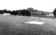
The central swing boat was popular with younger children, and the little girl in the centre seems to be anxiously waiting her turn.

By the 1950s, Bournemouth was at the height of its popularity and one of the most prosperous towns in England, as this view of the town centre shows.

The delightful timber- framed house in the centre of the picture is said to date from 1510.

The minster's twin towers dominate most pictures of East Street, but Hawker's new drapery shop (centre right) comes a close second in this shot.

The attractively crowded buildings in the centre of Hawkshead village are well displayed by this early photograph, with the former Market Hall on the left.

The former Cistercian monastery still dominates the grounds of Studley Royal, and is now served by an award-winning National Trust visitor centre on the hillside above.

Although the B1004 is called the High Street, it is South Street that provides the main shopping centre for the town.

Lexden Terrace (centre) was built in the Georgian style in 1843 by the builder and developer Captain John Rees.

The drinking fountain in the centre of this photograph was given to the town by R Grant JP in memory of his wife.

On the corner of Quay Road is Corner House of c1800 with black advertising panels (centre), now gone, alas.

Two of the older properties here - Lloyds Bank and the building beyond it (centre right) - still stand. St George's United Reformed Church stands behind the photographer.

It received a market charter from Charles II, and at its centre is a big triangular Market Place. The garage has now been replaced by public toilets.
Centre left is the Bethany Baptist Church, which opened in 1827 when 30 members left the Frogmore Street Church.
Places (57)
Photos (98)
Memories (1253)
Books (2)
Maps (316)

