

Places
8 places found.
Those places high-lighted have photos. All locations may have maps, books and memories.
Photos
282 photos found. Showing results 21 to 40.


Maps
284 maps found.


Books
1 books found. Showing results 25 to 1.
Memories
283 memories found. Showing results 11 to 20.
Growing Up In Brentwood
My name is Viv Bayliss, I was born in my nan’s house opposite the Alexandra public house in 1948. Mum and dad moved to a prefab in Costed Manor then to Pilgrims Hatch. Who remembers Preslands fair and listening to them playing all ...Read more
A memory of Warley by
Saturday Mornings
I lived in Albert Road Caversham Heights from 1948 aged 5. Went to school at Hemdean Road infants then on to Caversham Secondary Modern and left there in 1959. I really enjoyed school, especially maths, history and geography, the ...Read more
A memory of Caversham by
The Salford Girl
I was born in 1947 and lived at 52 West St, Lower Broughton, Salford 7. I attended St. John's School for girls, just off Chapel St. My parents were Annie and David Johnson. I had an older sister, Jean, and a younger brother, David. My ...Read more
A memory of Salford by
I Lived At Ferry Inn In 1952
I Lived At Rosneath, Ferry Inn. My father was in the Navy and we lived at Ferry Inn during 1952. There were three other families living there, the Thorntons and the Burtons. The Burtons were related to Shackleton, the ...Read more
A memory of Rosneath
My Memories Of Selly Oak And Bournbrook
I was born Anne Shirley Crofts back of 622 Bristol Road (opposite where Aldi is now) in July 1944, brother Ronnie was born 1940, sister Vivienne was born 1942, and Alan was born 1947, between Riverton Road ...Read more
A memory of Selly Oak in 1954 by
More Of Enfield
Swimming at the open air pool was so compulsory at George Spicer and then Kingsmead schools but then we grew a little and in the holidays worked at Pearsons and danced at the Court above Burtons in the market square. Those days it was ...Read more
A memory of Enfield in 1970 by
Ward End Adult School
The Ward End Adult School was held on Sunday mornings in 'The Barn', St.Margaret's Road, Ward End before the 2nd World War. It was run on a sort of religious basis, like a church (non-denominational, I think, but similar to ...Read more
A memory of Ward End in 1930 by
Bernard Knowles Brook
My grandmother was Lydia Brooks, her father was Bernard Knowles Brook. She lived with my mum and me at Burton Agnes Hall gatehouse until her death in 1949. My mother was Eedna Brook Wilson, born in 1904. Lydia Brook married John ...Read more
A memory of Keadby in 1900 by
Tweedsana Epsom High Street
Above "The Woolwich" (c1987-91) on the corner of Waterloo Road rhs also Mike Burton's "Radfords" Electrical Installation Design Consultants moved from 2a East Street(1984- 87) then to Church Street c1991-94. Mike now works from home near Plaistow, Sussex.
A memory of Epsom in 1987 by
My Parents And I Lived In Ashby Close Burton On The Wolds 1940 To1942
My father, Emilio de Althaus, and my mother Blanca spent weekends in Ashby Close, property of the Lembke family. My father was a Peruvian diplomat in London and came ...Read more
A memory of Burton on the Wolds in 1940 by
Captions
198 captions found. Showing results 25 to 48.

Although there are shops in higher Buxton, on High Street and the Market Place, the major commercial centre is Spring Gardens in the lower town.

St Leonard's was laid out by James Burton (father of the more famous Decimus Burton) after 1828.

F W Woolworth's, with its large window display and traditional sign, occupies a building which dates back to the 15th century, while the foundation stones of Burton's menswear shop, with its flamboyant

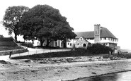
Built in 1806 and known as Burton Hall, this gracious old building was considerably altered in the 1900s by the new owners of the Burton Estate, the Gladstone family, who also changed its name to Burton

F W Woolworth's, with its large window display and traditional sign, occupies a building which dates back to the 15th century, while the foundation stones of Burton's menswear shop, with its flamboyant

Burton Bradstock lies just inland from the sea, close to the mouth of the River Bride, a charming little Dorset stream.

The River Trent at Burton is now crossed by three bridges: Burton Bridge, built in 1864, the iron Angelsey Bridge and the Stapenhill Viaduct, which is in fact a footbridge.
The River Trent at Burton is now crossed by three bridges: Burton Bridge, built in 1864, the iron Angelsey Bridge and the Stapenhill Viaduct, which is in fact a footbridge.

Branston is just two miles south of Burton, and at one time belonged to Burton Abbey. It was made a parish in its own right in 1870.
Branston is just two miles south of Burton, and at one time belonged to Burton Abbey. It was made a parish in its own right in 1870.

The tour starts with this excellent cameo shot which shows the heart and essence of Daventry, the Moot Hall, centre of local government during the 20th century, and the Burton Memorial, erected

Burton Street refers to the former leper hospital of St Mary and St Lazarus established about 1150 by Robert de Mowbray, to the south of the town; it can only be seen now as a series of earthworks to the

By 1895 Worthingtons pale and Burton ales were brewed at Burton-upon-Trent; William Worthington had opened his brewery there in 1760 some seventeen years before William Bass.

The parish church is dedicated to St Modwen, the founder of a 7th century Christian settlement at Burton.

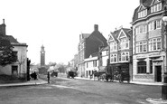
Burton`s the tailor's (right) had added an ornate exterior to the former modest buildings to the right of the Walk.

The railway came to Burton in 1839 with the opening of the Birmingham & Derby Junction.

A century ago, West Burton was a lively farming village with a market and many shops. The villagers bought the green from the lord of the manor in 1969.

Burton's the tailors displays its fine facade with Portland stone columns, which was created by rebuilding the corner of Horsemarket Street and Buttermarket Street in 1937.

It is houses like this that make Burton so attractive.

The village is viewed from the inland side of Burton Cliff, looking north-eastwards from above Dove Inn and Southover, to St Mary's Church (right).
With the building of the Southampton and Dorchester Railway, which opened in June 1847, East Burton was on the wrong side of the tracks from Wool and its village facilities.

We are looking inland north-eastwards from what is now National Trust land above Burton Cliff, over the Dove Inn and Southover (foreground) to the meadows of the River Bride (centre).

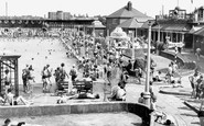
Chalets, a villa and the Bay View Hotel overlook the Hive and Burton Beach from the end of Beach Road. The sandy rocks of Burton Cliffs project towards Lyme Bay (left).

It is believed that the tall Wellingtonia trees on the right-hand side of the road were planted to commemorate the birth of the children of the Burton family.
Places (8)
Photos (282)
Memories (283)
Books (1)
Maps (284)

