Merry Christmas & Happy New Year!
Christmas Deliveries: If you placed an order on or before midday on Friday 19th December for Christmas delivery it was despatched before the Royal Mail or Parcel Force deadline and therefore should be received in time for Christmas. Orders placed after midday on Friday 19th December will be delivered in the New Year.
Please Note: Our offices and factory are now closed until Monday 5th January when we will be pleased to deal with any queries that have arisen during the holiday period.
During the holiday our Gift Cards may still be ordered for any last minute orders and will be sent automatically by email direct to your recipient - see here: Gift Cards
Places
36 places found.
Those places high-lighted have photos. All locations may have maps, books and memories.
- West End, Gwynedd
- West End, Hampshire (near Southampton)
- West End, Surrey (near Camberley)
- West End, Hampshire (near Medstead)
- West End, Leicestershire
- Ward End, West Midlands
- Shard End, West Midlands
- West End, Gloucestershire
- West End, Dorset
- West End, Strathclyde
- West End, Mid Glamorgan
- West End, Gwent
- West End, Hertfordshire
- West End, Suffolk
- West End, Sussex
- West End, Lancashire (near Morecambe)
- West End, Yorkshire (near Tadcaster)
- West End, Avon (near Nailsea)
- West End, Somerset (near Wells)
- West End, Oxfordshire (near Wallingford)
- West End, Berkshire (near Wokingham)
- West End, Norfolk (near Great Yarmouth)
- West End, Bedfordshire (near Great Staughton)
- West End, Kent (near Sittingbourne)
- West End, Yorkshire (near South Cave)
- West End, Avon (near Yate)
- West End, Wiltshire (near Shaftesbury)
- West End, Wiltshire (near Bowerchalke)
- West End, Berkshire (near Bracknell)
- West End, Yorkshire (near Driffield)
- West End, Yorkshire (near Hedon)
- West End, Lincolnshire (near Boston)
- West End, Cumbria (near Carlisle)
- West End, Yorkshire (near Cleckheaton)
- West End, Yorkshire (near Horsforth)
- West End, Oxfordshire (near Hardwick)
Photos
279 photos found. Showing results 1,361 to 279.
Maps
1,651 maps found.


Books
19 books found. Showing results 1,633 to 19.
Memories
2,057 memories found. Showing results 681 to 690.
Leaving School
So! Back to 11 Woburn Place, back to school on Hope Chapel Hill back to Hotwells golden mile with its 15 pubs. The War was still going on but there was only limited bombing and some daylight raids, the city was in a dreadful state ...Read more
A memory of Bristol in 1945 by
Animal Farm
It was either 1967 or '66, I can't quite recall. I was attending St Georges S M school Dersingham, when a producer came up from London and put our year through its paces to put on a performance from Animal Farm for the school. I ...Read more
A memory of Shernborne in 1967 by
Part 15
I remember Peter went in one day for a cup of tea, and stayed chatting. The horse got fed up waiting and came home five miles away. Peter was fuming; he had to walk home, and lost half a day’s earnings. He was ribbed rotten about ...Read more
A memory of Middle Rainton in 1945 by
A Young Boy In Cranford 1949 1955
My name is Michael Mancey. In 1949, when I was four years old, my parents, youngster sister and I, moved to a brand new council house in Windsor Road. Although the postal address was Hounslow West, it was in reality ...Read more
A memory of Cranford in 1950 by
North Acton, Victoria Road, Phillips Mapmakers
Does anyone else remember Phillips the Mapmakers in Victoria Road, North Action? I started there straight from school as a trainee (cartographer). I was only there 6 months before the bright lights and ...Read more
A memory of Acton in 1964 by
Working Days Then Retirement
After attending Newton village school from the age of 5 to 14, I found employment at a place called Tholthorpe where a new airfield was being built. Being 12 miles from my home I had to use a bicycle to get there ...Read more
A memory of Newton-on-Ouse in 1989 by
Kilburn High Road
My mother was brought up in Lowfield Road, so although we lived in West Hampstead, we frequently passed through it on our way to shop in Kilburn High Road. Passed through it far too slowly for my liking because my mother invariably ...Read more
A memory of Kilburn in 1940 by
I, Too, Was A Choirboy At St John's
I first attended St John's in around 1958 as a Cub Scout and attended the children's Sunday service at, ISTR, 9.40. The 'grown-ups' service at 11.00 seemed very serious to me as an 8 year old! I can't remember how I got ...Read more
A memory of Hove in 1959 by
Hesleden In The 1950s 1960s
I've visited the old place several times and where I was born and lived has gone! I was born at no.1 West Terrace in 1950, then moved across the road to Gladstone house on Station Road. My dad, Reg Wright, had a printing ...Read more
A memory of Hesleden in 1950 by
Old Document
I don't really have a memory- rather some antiquities associated with Whaplode. What I have are two medieval documents that refer to someone dying - probably of the black death that arrived in England & the area at the time the ...Read more
A memory of Whaplode by
Captions
1,993 captions found. Showing results 1,633 to 1,656.

Here we see two horse-drawn narrow boats, the 'Linnet' and the 'Evelyn', belonging to George Garside, at the attractively sited lock in Cassiobury Park, Watford.

Boucher married a local woman in 1787, and moved with his library to Woodcote House, which the Northeys were putting out to rent.

This is the west side of the market place; we have a better view of the church with its massive tower and noble parapets.

Consisting of little more than one long street running east to west, Glanton enjoyed a reputation for the healing properties of the water from the Keppin or Keppie Well situated behind the old school

Just to the west of Tregaron lies a vast bog, known as Cors Caron. This was once a lake that gradually filled with plants on which sphagnum moss grew.

The smaller standing stones in the middle of the circle are the famous Blue Stones and come from the Preseli Mountains in west Wales.

The name 'Finkle' comes from a Viking word meaning 'angle' or 'corner', and this less than straight street has not changed its line since those times.

Bevere Island is the second largest of all the natural islets in the River Severn and used to be a refuge for the citizens.

It is overshadowed by its wide tower which has a flatly projecting staircase; it is of early construction, despite the Perpendicular doorway, window, and arch to the nave and battlements.

This village stands on the south-west edge of the Isle of Ely. In the 17th century the fens around Sutton were drained by farmers with the help of wind pumps.

Bristol became a major centre for the importation of timber for use throughout the west of England. In 1870 it handled 105,000 tons, and by 1900 it was dealing with over 170,000 tons a year.
Bristol became a major centre for the importation of timber for use throughout the west of England. In 1870 it handled 105,000 tons, and by 1900 it was dealing with over 170,000 tons a year.

Lying in the tranquil Rye valley two miles west of Helmsley, Rievaulx was the first Cistercian monastery in the North of England. It was built in 1131 by French monks.

The Grand Union Canal emerges from the Braunston Tunnel east of Braunston village and descends past the village on a flight of six locks. This view looks west along the High Street.

The Phoenix and the attached shopping precinct to the west of the modern town centre are typical examples of the late 1950s to early 1960s New Town expansion.

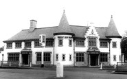
They are probably regulars from the hotel, and are going on a specially-organised day out.

We see a view of the main street here; this was probably as busy as it got in those days! The name Borden means 'woodland pasture by the hill'.

This well-known holiday resort, which has an excellent sandy beach, stands on the west coast of Wales at the mouth of the Mawddach estuary. Both Darwin and Ruskin enjoyed stays here.

All Saints' Church, built on a mound, was consecrated in 1190, and contains three bells, one of which weighs a ton.

Moving north-west from Albert Park to the Faringdon Road, the town tour finishes at the School of St Helen and St Katherine, as it is now named.

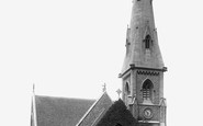
The vicar of St Mary's, F Leith Lloyd, wanted a larger church for his congregation, and engaged William Niven to design this enormous church at a cost of £30,000.

The lord of the manor, William Gossip, purchased land here with the view to owning a substantial but convenient house in this rural part of the West and North Yorkshire border.

St Mary Magdalene's church runs west from the Market Place and was heavily Victorianised and extended – the new chancel's foundation stone was laid by the Duke of Portland in 1887.

In this town we will find a fascinating mixture of alleyways, courtyards and shambles. Many of the houses date from the 17th century.
Places (99)
Photos (279)
Memories (2057)
Books (19)
Maps (1651)

