

Places
26 places found.
Those places high-lighted have photos. All locations may have maps, books and memories.
- Cemmaes Road, Powys
- Six Road Ends, County Down
- Road Weedon, Northamptonshire
- Severn Road Bridge, Gloucestershire
- Roade, Northamptonshire
- Berkeley Road, Gloucestershire
- Harling Road, Norfolk
- Road Green, Devon
- Builth Road, Powys
- Cross Roads, Yorkshire
- Steele Road, Borders
- Cross Roads, Devon
- Four Roads, Dyfed
- Road Green, Norfolk
- Biggar Road, Strathclyde
- Clarbeston Road, Dyfed
- Five Roads, Dyfed
- Eccles Road, Norfolk
- Grampound Road, Cornwall
- Morchard Road, Devon
- Wood Road, Greater Manchester
- Four Roads, Isle of Man
- St Columb Road, Cornwall
- Clipiau, Gwynedd (near Cemmaes Road)
- New Road Side, Yorkshire (near Silsden)
- New Road Side, Yorkshire (near Cleckheaton)
Photos
14,329 photos found. Showing results 1,421 to 1,440.


Maps
476 maps found.
Books
5 books found. Showing results 1,705 to 5.
Memories
11,058 memories found. Showing results 711 to 720.
Brian Taylor
I lived at 144 Cheam Common road from 1950 till 1960 ,and went to Cheam Common School then Stoneliegh east secondary we moved to Lavender Avenue North Cheam in 1960 , I was a member of the 10th Sutton Boys Brigade.
A memory of Worcester Park by
Hounslow Hospital, Staines Road 1985
This was the Hounslow cottage hospital on the Staines Road, Hounslow at the top of Hibernia Road. It was demolished in about 1985-1990 after being left empty for a number of years. On the site today stands a ...Read more
A memory of Hounslow in 1985 by
The Bushey Arches Traffic!
I first saw Oxhey in 1956 when I would take the train from Hatch End to Bushey & Oxhey station (as it was called then) on Saturday afternoons to see Watford play football at Vicarage Road in the old Third Division South. The ...Read more
A memory of Oxhey in 1956 by
Where I Grew Up With My Sister Christine & Dog Judy
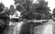
This picture is the view from the main road of Harlow lock, Old Mill Resturant and weir and the towpath where the rowing boats and canoes were moored when I lived there. They were moored both sides of ...Read more
A memory of Harlow in 1950 by
The Bakery
When I lived in the village there was a bakery at the building on the corner of this road where it went down to the canal. The flour was ground at the Mill over the drawbridge for making the most delicious bread you could buy in those ...Read more
A memory of Lower Heyford in 1940 by
The Brampton Hawk Moth Club.
Searching for wildlife to keep as pets was a major diversion for a small group of boys in my class at Brampton Road Primary School during the 1950's. Anything that moved on the ground or swam around in ponds and streams ...Read more
A memory of Bexleyheath by
Better Than A Knickerbocker Glory
Following a week at school the weekend was always eagerly anticipated, especially Saturdays. On this day I would take the long walk from home at the north end of Gipsy Road and make my way via Pickford Road to the west ...Read more
A memory of Bexleyheath by
Bilton Road In The "69d
I born in 1955. Went to Perivale Infants and Junior schools before going to Greenford County Grammar School. I was in 6 Perivale Scouts. I still have fond memories of Justice's fish and chips, working in Empire Greengrocers, ...Read more
A memory of Perivale by
Grandma's Shop
I was born Nov 5, 1939 at 81 Star Lane, the home of my maternal grandparents, James and Anne Maria Bullock. My mother, Annie Grace Bullock, was the youngest of six children. She married my father, Henry George Hooper, in 1935 at ...Read more
A memory of Canning Town by
"The Stores" Station Road
My late Great Grandfather had a bakery at "The Stores" F.W.Dobson bakers in about 1948. I wonder if anyone remembers him or if there are any photos of the shop. His nam was Frank. Many thanks Diane
A memory of Halstead by
Your search returned a large number of results. Please try to refine your search further.
Captions
5,036 captions found. Showing results 1,705 to 1,728.
 c.1965, Warrington")
Known locally as 'The Cantilever', this high level fixed bridge provides a welcome escape route when the Knutsford and London Road swing bridges are closed.

This steep curving road is celebrated for its row of 17th-, 18th- and 19th-century cottages in tile-hung brick and stucco, which stagger uphill raised above the roadway in traditional Surrey fashion.

The Victorian development of Torquay was definitely the province of the well-heeled, with sumptuous villas built along carefully contoured roads.

The beautiful surrounding coastline is lonely and unspoiled once the roads and traffic are left behind.

Thatch, unsurfaced road and total absence of traffic was the norm. Today, most of these views have gone.

The cobbled streets are much in evidence, and the road belongs to pedestrians.

Indeed, little has changed, save the re-routing of the main road that ran through the centre.

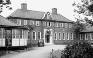
Sherborne School for Girls dating from 1899 and founded by Mrs Kenelm Wingfield Digby, is here seen on Bradford Road - its home from 1903.

This elegant single span over the river Severn takes the A4133 Droitwich to Tenbury Wells road. It was built in 1828 by that noted engineer Thomas Telford.
The beautiful surrounding coastline is lonely and unspoiled once the roads and traffic are left behind.

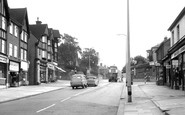
New Road Side is here still a street of small, traditional shops.

Sixty years on, Beccles has declined as a port, with goods being carried more by road. The church is unusual in that the 92 feet high tower is actually separate from the nave.

From high up on Yeld Road, the parish church makes an interesting study. Compare this view with photographs 73886 and B6020, taken in later years, and note the changes - or lack of them.

Once there had been a bowling green near the town centre, commemorated by Bowling Green Road. When Charles Wicksteed opened the park, bowls and putting became popular with the people who lived nearby.
Once there had been a bowling green near the town centre, commemorated by Bowling Green Road. When Charles Wicksteed opened the park, bowls and putting became popular with the people who lived nearby.

Roads around Bristol were turnpiked from the 1720s, though many were short stretches and often only seven feet wide.

Children walk along the road with their mother. Behind the brick wall is a late Victorian farmhouse, and opposite this some newly-built bungalows with new gardens. The Lanes lead to Over Mill.

At this point the main Leominster to Hereford road starts to climb the steep hill. Stagecoaches would have been forced to stop here to pay their toll at the toll house overlooking the junction.

Park Lane, once the desolate by-road known as Tiburn Lane, was a refined street of palatial mansions enjoying expansive vistas of the Park.

There are cart tracks in the loose, unsealed road surface. Children wait at the roadside, perhaps for transport to school. There are no vehicles in sight; it was a quiet village.

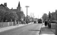
We can see a tram climbing North Road. When the trams first ran in 1901, only one had brakes strong enough to use the hill, so passengers had to change at the top.

The shops on the left were built with bricks from the Nevendon Road brickworks. The shrubs conceal Ladybrow, a former doctor's house and surgery.

A range of 15th- and 16th-century timber- framed houses, some jettied, the Rose and Crown follows the curve of a lane linking Ipswich Road and East Street.

The road is now narrower with wider pavements.
Places (26)
Photos (14329)
Memories (11058)
Books (5)
Maps (476)

