

Places
26 places found.
Those places high-lighted have photos. All locations may have maps, books and memories.
- Town End, Derbyshire
- Town End, Buckinghamshire
- Town's End, Somerset
- Towns End, Dorset
- Town End, Merseyside
- Town End, Cambridgeshire
- Town's End, Buckinghamshire
- West End Town, Northumberland
- Bolton Town End, Lancashire
- Kearby Town End, Yorkshire
- Town End, Cumbria (near Grange-Over-Sands)
- Town End, Cumbria (near Bowness-On-Windermere)
- Town End, Yorkshire (near Huddersfield)
- Town End, Yorkshire (near Wilberfoss)
- Town End, Cumbria (near Appleby-in-Westmorland)
- Town's End, Dorset (near Melbury Osmond)
- Town's End, Dorset (near Swanage)
- Town End, Cumbria (near Ambleside)
- Town End, Cumbria (near Lakeside)
- Town End, Cumbria (near Kirkby Lonsdale)
- Town End, Cumbria (near Ambleside)
- Town's End, Dorset (near Bere Regis)
- West-end Town, South Glamorgan
- Townend, Derbyshire
- Townend, Strathclyde (near Dumbarton)
- Townend, Staffordshire (near Stone)
Photos
23 photos found. Showing results 4,121 to 23.
Maps
195 maps found.
Books
3 books found. Showing results 4,945 to 3.
Memories
3,719 memories found. Showing results 2,061 to 2,070.
Park Farm
I lived in Colliers Green at Park Farm, at that time a dairy and fruit farm. I went to school at the primary school. Just down the road was a charcoal burners. Latterly I went to Bethany School at Curtisen Green. Good memories.
A memory of Colliers Green in 1961 by
One Of The Boys
On a Sunday a crowd of boys and girls would meet at the Sky High milk bar at the Bell end of the High Street. After a few milk shakes we would then go to the pictures, either the Regal or the Alcaza and sometimes go to the other end ...Read more
A memory of Hounslow in 1948 by
Sister Enid Butlers Orphanage
I was a child that lived at the 'Sister Butler's orphanage' in the early I960s. This message is to anyone that was also at the orphanage at that time, particularly Alison Burbidge, as I have read her account ...Read more
A memory of Hinton Martell in 1960 by
I Remember
I was born in Ilford in 1961, in Stanley Road, opposite the cemetery of St Mary the Virgin! I remember well shopping trips 'Up Ilford' with Mum or Dad as a child. I remember too, going into C&A for clothes, and visiting the Clarkes shoe ...Read more
A memory of Ilford by
Castle School Stanhope
Well, I have been reading some articles posted on this website, about Castle School in Stanhope from the late 1970s to the early 1980s. Well, I was in Castle School from 1958 - 1962. I was in because I was a badden, lol, just ...Read more
A memory of Stanhope by
3 Skulls
To reply to Sandra, the 3 skulls have now been replaced behind a safer glass case. I live in Goldthorpe but my husband's family share some links with Hickleton from the family branch of his mother's side. His grandmother had some relations ...Read more
A memory of Hickleton in 2009 by
Why Do I Remember Salford
I have lived all over the world, call myself an Australian and I currently live in Prague. But I was born in Salford and lived there probably till I was about 7 years old. Then we moved to Middleton which was considered quite ...Read more
A memory of Salford in 1952 by
Cottage Opposite Hart Road Caravan Site
I remember a beautiful old, I think thatched, cottage situated opposite the entrance to the caravan site in Hart Road, Thundersley, opposite the phone box. It had brightly painted plaster figurines wearing ...Read more
A memory of Thundersley in 1964 by
Feather Bed Lane
Yes that's right. On a big corner turning from the London/Croydon Road. Feather Bed Lane seems to have ben so called as there were a number of poultry people along there. Mainly.. dreaded Geese! An Uncle, Aunt and cousin with ...Read more
A memory of New Addington by
Cauldon Low Cricket Club
Whilst going through a number of items handed down to me by my late grandfather Ronald Arthur Rayson of Suffolk who passed away in 1982, I found a medal from the Leek and District Cricket League with an inscription ...Read more
A memory of Cauldon Lowe in 1900 by
Captions
5,054 captions found. Showing results 4,945 to 4,968.

This photograph, probably taken from the top of St Mary Woolnoth Church, shows the view west down Poultry which leads directly into Cheapside.

The Belfast and County Down Railway used their Slieve Bearnagh trips to Portrush or Portaferry with cruises up Strangford Lough.

It would be difficult to say now, without consulting early maps, exactly where 18th-century Whetstone began and finished on the Great North Road.

This photograph gives us the opportunity to look down the street and into Hargreaves Street, where the GPO stands (54191, page 46).

The design of this huge, ancient giant, on the South Downs near Eastbourne, is cleverly elongated vertically to counteract the effect of foreshortening when viewed from below the hillside.

This building was erected in 1911 when the original inn burnt down. There has been an inn on this site since the 12th century; it was originally a cider house, part of an orchard.

Down by the river bank, the paviours follow the line of the medieval wharf. Behind the moat are the medieval outer defences, the inner one overlooking the outer - the battlements are 19th-century.

The pier, the second longest in the country after Southend's, reached out from the mile and a half long esplanade and was built in 1832 to shorten the time taken to travel to the continent.

As we have already seen, Breconshire is renowned for its many waterfalls and caves in the far south west.

The bridge was the first structure of its kind in the world, and is pictured here when it was 64 years old. The bridge is best viewed from Belgian Promenade which overlooks the water.

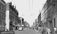
Now we look westwards down the south side of West Street, from Knight and Son, tailors (far left). The next building housed stationer and printer W Frost who published the 'Bridport News'.

It says a lot for this land- scape that artists of all kinds have responded to it and interpreted it in diverse ways.

Immediately south-east of Lingfield lies the race course, founded in 1890, and beyond that is the next station on the railway line, Dormans.

The local Board of Health had put their foot down over the amount of debris that the market was depositing in the High Street every Friday. It was February 1880 when the new site opened.

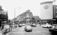
New Brighton is situated on the extreme tip of the Wirral Peninsula, and is separated from the busy city and port of Liverpool by the River Mersey.

The Buttertubs Pass leads dramatically down to this village, which is 9 miles west of Muker. It was hit by a natural disaster in 1898, the result of a cloud burst.

Among the market traders who used to draw the crowds were Mrs Gee, who literally sold crockery at knock down prices by shouting out the price and banging on an old tea chest.

The lifeboat was slung on a wheeled cradle which would be hauled out of the station, down the ramp immediately in front of it, and into the sea; the boat floated off once there was sufficient water under
The lifeboat was slung on a wheeled cradle which would be hauled out of the station, down the ramp immediately in front of it, and into the sea; the boat floated off once there was sufficient water under

Between the two world wars Jack Perrin, who lived in the nearby Hagg Cottages, used to sit by the entrance and sell half candles to people who wanted to go down the mine.

This view from Skerton Bridge looks back down the River Lune to Lancaster.

Moving south to the Cuckmere River valley, our tour reaches Upper Dicker, about two and a half miles west of Hailsham.

This was the second palace on the site: the first, built originally for the 1862 International Exhibition, burnt down just two years after being opened in 1873 as north London's rival to the south's Crystal

Davenham gets its name from the River Dane (a 'trickling stream'), although it sits just about halfway between it and the River Weaver.
Places (26)
Photos (23)
Memories (3719)
Books (3)
Maps (195)

