

Places
36 places found.
Did you mean: street or streetly ?
Those places high-lighted have photos. All locations may have maps, books and memories.
- Heathfield, Sussex (near Cade Street)
- Street, Somerset
- Chester-Le-Street, Durham
- Adwick Le Street, Yorkshire
- Scotch Street, County Armagh
- Friday Street, Surrey
- Potter Street, Essex
- Boughton Street, Kent
- Newgate Street, Hertfordshire
- Streetly, West Midlands
- Shalmsford Street, Kent
- Green Street Green, Greater London
- Boreham Street, Sussex
- Park Street, Hertfordshire
- Cade Street, Sussex
- Appleton-le-Street, Yorkshire
- Hare Street, Hertfordshire (near Buntingford)
- Romney Street, Kent
- Trimley Lower Street, Suffolk
- Streetly End, Cambridgeshire
- Hare Street, Hertfordshire (near Stevenage)
- Brandish Street, Somerset
- Colney Street, Hertfordshire
- Langley Street, Norfolk
- Silver Street, Somerset (near Street)
- Street, Yorkshire (near Glaisdale)
- Street, Lancashire
- Street, Devon
- Street, Cumbria (near Orton)
- Street, Somerset (near Chard)
- Bird Street, Suffolk
- Black Street, Suffolk
- Ash Street, Suffolk
- Broad Street, Wiltshire
- Brome Street, Suffolk
- Penn Street, Buckinghamshire
Photos
21,808 photos found. Showing results 4,161 to 4,180.


Maps
1,622 maps found.
Books
1 books found. Showing results 4,993 to 1.
Memories
6,666 memories found. Showing results 2,081 to 2,090.
1952
I was born in the July of 1952,to my parents Frank and Bette Coxon. We lived above a butchers shop, on the corner of the Wednesfield Road and Heath street - the shop belonged to Mr Sammy Hall. My father worked as a butcher at Downs of ...Read more
A memory of Heath Town in 1952 by
The Brambles Abel Family
My grandmother used to live in a house called The Brambles in Church Street, as a young girl during the 1920`s when she was about 8 or 9. The family name was Abel- relating to Bobby Abel the famous cricketer. My great ...Read more
A memory of Crondall in 1920 by
Buckhaven In The Late Thirties And The 50's
In the late thirties, my mother worked as a dispatcher in Stuarts Bakery in Church Street just down from the junction with Randolph Street. This building has been closed down now for many years. In the ...Read more
A memory of Buckhaven in 1950 by
Old Blackburn Lass
I was born in 1933 and brought up in Proctor Street, Grimshaw Park. I attended Christ Church School and then Audley Modern Secondary school from 1944 - 48. I left school and worked at Ewood Mill until going nursing in 1950 to The ...Read more
A memory of Blackburn in 1930 by
Times Past
I was born in 1951 and lived for the first 2 years of my life at 241 the Blocks with my parents and Grandparents. This was a 2 up 2 down + attic house in a block of 3 situated on the bottom row of the blocks, now demolished. ...Read more
A memory of Barrow Hill in 1951 by
Gaslight 1954
In the early 50's many streets in Uxbridge were still lit by gas. So "lighting up time" had a whole different meaning. The iron lampposts were much lower than the lighting masts of today and were more widely placed along the streets. ...Read more
A memory of Uxbridge in 1954 by
Fond Memories.
I lived in Coval Lane from my 1st birthday to my 24th birthday - 1948/1971. Then I got married and moved out. At that time the shop on the corner was a wool shop because my mum, an ardent knitter, bought most of her wool there. I ...Read more
A memory of Chelmsford by
40s/50s
Early memories of Buckhurst Hill. Re. Mark Brazier's message. Yes I remember the Three Colts and the French family. The son David was a close friend so I spent a lot of time there. I remember your mother and father Audrey and Ged ...Read more
A memory of Buckhurst Hill by
Great Memories Of Durham City
My Uncle Gordon was the police man who used to sit in the police box at the top of the street in the market square directing traffic. This was around 1950s. I used to live in Meadowfield and came to Durham many, many ...Read more
A memory of Durham by
The Mining Industry Abercynon Colliery
I worked under ground at Abercynon Colliery from 1951 until 1953. I worked on the coal face in the "S" district, a five foot coal seam which was about 100 yards in length and which had a slight gradient. I ...Read more
A memory of Abercynon in 1950 by
Captions
5,381 captions found. Showing results 4,993 to 5,016.

As an example, consider the size of the Post Office on the left of Bedford Street. It is doubtful if it could cope with the demands of modern visitor throughput.

Their name lives on in medieval Kirkham House (see the drawing above) and Kirkham Street.

to Cathedral status in 1927, the building, although exhibiting 13th-century fabric, exudes an air of Victorian England, for it was 'restored' and added to by such hallowed names as George Edmund Street

Not visible in this photograph, but well worth walking to see at the west end of the street, is St Stephen's church, a large and handsome building which was founded before the Norman Conquest.

Looking down High Street we see, right, North End Cottage, now the post office. On the left is the Old Hall and the Catholic church, Our Lady of Mount Grace.

Downhill to the south and across the River Maun, the High Street continues uphill to pass The Dukeries Hotel, now for some reason called Ma Hubbard's Eating House and Hotel.

There used to be a horse fair here - the streets were blocked by straw bales to keep the animals in. The ancient market was restored in 1834; it was held every Friday.

Across the road, on the corner of Mersey Street, the Packet House Inn hints at the days when packet boats carried passengers along the Mersey to Liverpool.
(Nick Thomas) Church Lane, viewed from Water Street. This is one of the pleasantest parts of the town.

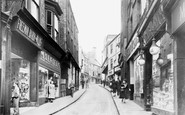
The steep, winding and narrow High Street (down which flaming tar barrels were rolled to the terror of the populace until the practice was banned in 1824) gives an excellent impression of

Liverpool Road was a long road running from Church Street, Eccles to the airport out at Barton.

The Sessions House on William Brown Street is pictured here just three years after it opened. Designed by F & G Holme, its original purpose has now been forgotten.

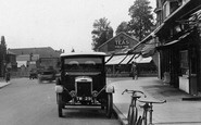
The bicycles parked outside the bank on the left might well have been bought at the Cycle & Sports Depot farther down the street.

This is the main shopping street of Sleaford, and the Handley Memorial was the ideal place for a set of destination signs.

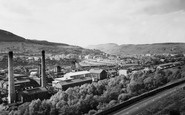
After 1870 Currey produced his second master plan for the areas around the hamlet of Meads, this time for tree-lined streets of villas and houses in grounds that led to this western development being

Some of the flavour of the old village remains in this view today, which looks eastwards along Broadwater Street East.
The bicycles parked outside the bank on the left might well have been bought at the Cycle & Sports Depot farther down the street. Thoughts of war seem far away in this peaceful, unhurried scene.

Our last view in this chapter before turning north back to Hailsham shows the Horse and Groom pub at the junction of the High Street and the Eastbourne Road, the A22.

Station Road, behind the photographer, is the main shopping street, and now has two major supermarkets.

Ockley is a very fine village along the course of the Roman road from London to Chichester, which has been known from Anglo-Saxon times as Stane Street.

In the last forty or so years, very little has changed in the High Street, although the recently built premises of the Midland Bank (right) has now become a private house.

It is now an unprepossessing village, with some pleasing weatherboarded houses in the High Street. On the right are two public houses - the Victoria and the Black Bull.

Here we see another view of the main street. The jaunting car tells of the recent changes, and the lamps tell of a gasworks only waiting to be expanded.

These buildings give a cottagy feel to what is essentially a commercial street, as we can see from the buildings opposite - they house a shop, a pub and the outbuildings of a brewery.
Places (385)
Photos (21808)
Memories (6666)
Books (1)
Maps (1622)

